Home > Europe > Republic of Ireland > Maps
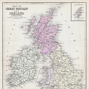
Map of Great Britain and Ireland 1896

![]()
Wall Art and Photo Gifts from Fine Art Storehouse
Map of Great Britain and Ireland 1896
Andres Allgemeiner Handatlas - Bielefeld und Leipzig 1896
Unleash your creativity and transform your space into a visual masterpiece!
THEPALMER
Media ID 18357075
FEATURES IN THESE COLLECTIONS
> Europe
> Republic of Ireland
> Maps
> Fine Art Storehouse
> Map
> Historical Maps
> Maps and Charts
> Early Maps
EDITORS COMMENTS
This print showcases a remarkable piece of history, the "Map of Great Britain and Ireland 1896" from Andres Allgemeiner Handatlas - Bielefeld und Leipzig 1896. With exquisite detail and precision, this vintage map takes us back to an era where cartography was both an art form and a scientific endeavor. The Map of Great Britain and Ireland in 1896 offers a fascinating glimpse into the geopolitical landscape of that time. It beautifully illustrates the intricate network of cities, towns, rivers, mountains, and coastlines that define these two nations. Each line meticulously drawn represents not only geographical boundaries but also cultural connections that have shaped their shared histories. As we delve into this historical artifact captured by THEPALMER for Fine Art Storehouse, we are transported to an age when exploration was at its peak. The delicate hues used on this print add a touch of nostalgia while enhancing our appreciation for the craftsmanship involved in creating such detailed maps before modern technology took over. Whether you are an avid historian or simply captivated by the beauty found in old-world cartography, this print is sure to spark curiosity and ignite conversations about how our world has evolved over time. Display it proudly as a testament to human ingenuity and as a reminder that even in today's digital age, there is still something magical about holding tangible pieces of our past within our hands.
MADE IN AUSTRALIA
Safe Shipping with 30 Day Money Back Guarantee
FREE PERSONALISATION*
We are proud to offer a range of customisation features including Personalised Captions, Color Filters and Picture Zoom Tools
SECURE PAYMENTS
We happily accept a wide range of payment options so you can pay for the things you need in the way that is most convenient for you
* Options may vary by product and licensing agreement. Zoomed Pictures can be adjusted in the Cart.