Fraud Blocker Skip to main content

Home > Africa > Togo > Maps

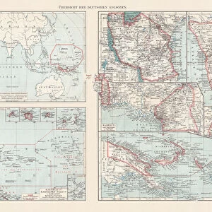
Map of Togo 1900

 : Map of Togo 1900
In Stock
We accept all major payment options so you can pay for the things you need in the way that is most convenient for you

Choose Your Product

Framed Photos
Buy from AU$119.99
Photo Prints
Buy from AU$12.99
Jigsaw Puzzles
Buy from AU$89.99
Poster Prints
Buy from AU$24.99
Canvas Prints
Buy from AU$124.99
Fine Art Prints
Buy from AU$92.53
Metal Prints
Buy from AU$43.99
Cards
Buy from AU$12.99
Home Decor
Buy from AU$24.99

Fine Art Storehouse Photo Prints and Wall Art

Map of Togo 1900

Meyers hand-Atlas Leipzig und Wien Verlag des Bibliographischen Instituts 1900. Unleash your creativity and transform your space into a visual masterpiece. © 2014 Roberto Adrian Photography

THEPALMER

Media ID 18106915

FEATURES IN THESE COLLECTIONS

> Africa > Togo > Maps

> Africa > Togo > Related Images

> Fine Art Storehouse > Map > Historical Maps

> Fine Art Storehouse > Map

SECURE PAYMENTS
We accept all major payment options so you can pay for the things you need in the way that is most convenient for you

Made in Australia
Safe Shipping, Easy Returns

FREE PERSONALISATION
We are proud to offer a range of customisation including Cropping, Captions, and Filters. Zoom Cropping can be adjusted in the basket


EDITORS COMMENTS

This print showcases a rare gem from the past - the "Map of Togo 1900". With its origins dating back over a century, this historical artifact offers us a glimpse into the world as it was in that era. The map, originally published in Leipzig und Wien by Verlag des Bibliographischen Instituts in 1900, is an exquisite example of cartographic artistry. The intricate details and meticulous craftsmanship evident on this map are truly remarkable. Every contour and boundary line has been delicately etched onto the paper, revealing Togo's geographical features with utmost precision. As we gaze upon this vintage masterpiece, we can't help but marvel at how far cartography has come since then. Beyond its aesthetic appeal, this print serves as a time capsule connecting us to an era long gone. It sparks curiosity about what life was like in Togo during those times - the bustling cities, remote villages nestled amidst lush landscapes, and untrodden paths waiting to be explored. "The Map of Togo 1900" transports us back to an age when maps were cherished possessions that guided adventurers and explorers through uncharted territories. It reminds us of our innate human desire for discovery and understanding of our surroundings. Thanks to THEPALMER's skillful preservation work and Fine Art Storehouse's dedication to sharing these treasures with art enthusiasts worldwide, we have the privilege of owning or admiring this extraordinary piece today. Let it inspire you to embark on your own journey of exploration -.


Framed Prints of Map of Togo 1900

Step back in time with our exquisite Framed Print of "Map of Togo 1900" by THEPALMER from the Media Storehouse Fine Art Storehouse collection. This captivating vintage map, originally published in the Meyers Hand-Atlas Leipzig und Wien Verlag des Bibliographischen Instituts 1900, showcases intricate detail and historical accuracy. Bring a touch of history into your home or office with this beautiful, framed piece, perfect for avid collectors, cartography enthusiasts, or anyone who appreciates the allure of the past. Add this unique conversation starter to your decor and transport yourself on a journey through time.


Photo Prints of Map of Togo 1900

Discover history through the lens with our exquisite "Map of Togo 1900" photographic print from THEPALMER's Fine Art Storehouse collection. This captivating piece is taken from the Meyers Hand-Atlas published by the Bibliographischen Instituts Leipzig und Wien Verlag in 1900. Each detail in this vintage map print is meticulously captured, allowing you to explore the intricacies of Togo's geography during this historic period. Bring a piece of the past into your home or office and elevate your decor with this unique and thought-provoking photographic art.


Poster Prints of Map of Togo 1900

Step back in time with our stunning Map of Togo 1900 print from THEPALMER's Fine Art Storehouse collection. This captivating poster, originally published in the Meyers Hand-Atlas Leipzig und Wien Verlag des Bibliographischen Instituts in 1900, offers a fascinating glimpse into the historical geography of Togo during a pivotal period. Add an air of nostalgia and intrigue to any room with this beautifully preserved piece of cartographic history. Order now and transport yourself back in time.


Jigsaw Puzzles of Map of Togo 1900

Discover the rich history of Togo with our intricately detailed Jigsaw Puzzle from Media Storehouse. Featuring the vintage "Map of Togo 1900" by THEPALMER from the Fine Art Storehouse, this puzzle brings the past to life. Meticulously reproduced from the original Meyers Hand-Atlas Leipzig und Wien Verlag des Bibliographischen Instituts 1900, this puzzle offers a challenging yet rewarding puzzle experience. Immerse yourself in the historical cartography and geographical exploration of Togo with this beautiful and educational puzzle. Perfect for history enthusiasts, puzzle collectors, or anyone seeking a captivating and engaging activity.

diamond
Made With High Grade Materials
thumb_up
Professional Quality Finish
package_2
Carefully Packed To Aid Safe Arrival

You May Also Like


Hillman 1950s UK jubilee edition hillman minx carsHillman 1950s UK jubilee edition hillman minx cars
Add to Basket
Irrestibile 1930s USA make-up makeup make up womens pin-up pinups pin-ups iwsIrrestibile 1930s USA make-up makeup make up womens pin-up pinups pin-ups iws
Add to Basket
Iceland scallop (Chlamys islandica), shellsIceland scallop (Chlamys islandica), shells
Add to Basket
Mauritius RacetrackMauritius Racetrack
Add to Basket
Albania Vector MapAlbania Vector Map
Add to Basket
Spain. Barcelona. Exhibition of Fine Arts. Engraving. ColoreSpain. Barcelona. Exhibition of Fine Arts. Engraving. Colore
Add to Basket
Bosnia and Montenegro map 1893Bosnia and Montenegro map 1893
Add to Basket
Flat map of Central African Republic with flagFlat map of Central African Republic with flag
Add to Basket
Map of Poland and Western Russia (Belarus), lithograph, published 1897Map of Poland and Western Russia (Belarus), lithograph, published 1897
Add to Basket
Laos locator mapLaos locator map
Add to Basket
Series of pictures from Abyssinia, Ethiopia, war dance, digitally restored reproduction of a collector's picture from ca 1900Series of pictures from Abyssinia, Ethiopia, war dance, digitally restored reproduction of a collector's picture from ca 1900
Add to Basket

Gallery Wall Inspiration

Map Of New Holland
Antique map of Britain under the Anglo Saxons
Map of India 1900
Map of Dorset 1883
Antique map of the Roman Empire
Map of Middle East - illustration
Map of Cyprus, published in 1880
Antquie Map of London, 1880
Map of Anglo-Saxon Kingdoms and the Danelaw, 9th Century
Antique map of Britain under the Ancient Romans
Apostle Pauls Missionary Journeys, lithograph, published in 1886
Earth map according to Herodotus
Sicily map 1895
Battle Of Waterloo
Map of Cyprus
Antique map, Scotland, Jura, Mull, Argyll, Islay 19th Century
Map of Devon 1883
Map of Ireland 1897
Antique map of Tasmania
Ethnological map of the Austro-Hungarian Empire, lithograph, published in 1897
Cornwall map 1884
Antique map of Ireland
Old map of Australia 1899
Antique map of New Zealand in the 19th Century, 1873
Antique map of Hadrians wall
Greece at the beginning of the Peloponnesian War (431-404 BC)
Map of Portugal

Discover Our Collections


MapMap
View Collection
Togo Related ImagesTogo Related Images
View Collection
MapsMaps
View Collection
Historical MapsHistorical Maps
View Collection


© Copyright Media Storehouse, All Rights Reserved 2003 - 2025
Facebook     Pinterest     100% Payment Secure     Reviews IO