Home > Maps and Charts > World
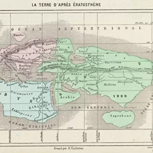
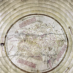
World map according to Eratosthenes

![]()
Wall Art and Photo Gifts from Fine Art Storehouse
World map according to Eratosthenes
World map according to Eratosthenes - Scanned 1899 Engraving
Unleash your creativity and transform your space into a visual masterpiece!
benoitb
Media ID 18106837
FEATURES IN THESE COLLECTIONS
> Fine Art Storehouse
> Map
> Historical Maps
> Maps and Charts
> Early Maps
> Maps and Charts
> World
EDITORS COMMENTS
This print showcases the incredible "World map according to Eratosthenes" a scanned 1899 engraving that takes us back in time to explore the ancient world. Created by Benoitb, this artwork beautifully captures the essence of Eratosthenes' vision and his profound contribution to cartography. Eratosthenes, a renowned Greek mathematician and geographer, meticulously charted the known world during his era. This remarkable map transports us to an era where Scythia, Ariana, Sogdiana, and Brettania were prominent regions on Earth's canvas. It offers a glimpse into how our ancestors perceived their surroundings and navigated through vast lands. The intricate details of this engraving are truly awe-inspiring. Every line etched with precision tells a story of exploration and discovery. The delicate strokes bring life to mountains, rivers, coastlines, and borders that once defined civilizations long gone but not forgotten. As we gaze upon this historical masterpiece from Fine Art Storehouse's collection, we can't help but marvel at how far humanity has come in mapping our planet since Eratosthenes' time. It serves as a reminder of our innate curiosity about the world around us—a curiosity that continues to drive scientific advancements today. Benoitb's photograph preserves this invaluable piece of history for generations to come. Through it, we are transported across continents and centuries—immersing ourselves in an ancient perspective while appreciating the artistry behind one man
MADE IN AUSTRALIA
Safe Shipping with 30 Day Money Back Guarantee
FREE PERSONALISATION*
We are proud to offer a range of customisation features including Personalised Captions, Color Filters and Picture Zoom Tools
SECURE PAYMENTS
We happily accept a wide range of payment options so you can pay for the things you need in the way that is most convenient for you
* Options may vary by product and licensing agreement. Zoomed Pictures can be adjusted in the Cart.