Home > Maps and Charts > World
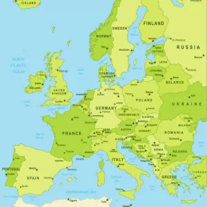
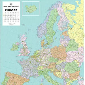
Political map of Europe

Wall Art and Photo Gifts from Fine Art Storehouse
Political map of Europe
Vector illustration of the policital map of Europe
Reference map was created by the US Central Intelligence Agency and is available as a public domain map at the University of Texas Libraries website.
https:/cia.gov/library/publications/resources/the-world-factbook/graphics/ref_maps/political/pdf/europe.pdf
Unleash your creativity and transform your space into a visual masterpiece!
Media ID 15192882
FEATURES IN THESE COLLECTIONS
> Europe
> Related Images
> Fine Art Storehouse
> Map
> Reference Maps
> Maps and Charts
> World
EDITORS COMMENTS
This print showcases a meticulously detailed political map of Europe, brought to life through a stunning vector illustration. Every country, border, and major city is intricately depicted, offering an immersive visual experience that invites exploration and discovery. What makes this particular artwork even more fascinating is its reference source. Created by the US Central Intelligence Agency (CIA), this map holds immense credibility and accuracy. The fact that it is available as a public domain map at the University of Texas Libraries website further emphasizes its reliability and accessibility for all knowledge seekers. The beauty of this print lies not only in its aesthetic appeal but also in its educational value. It serves as an invaluable resource for students, researchers, or anyone with an interest in European geography or politics. Whether you're planning your next adventure across the continent or simply expanding your understanding of global affairs, this artwork provides a comprehensive overview of Europe's political landscape. With Fine Art Storehouse bringing this masterpiece to life through their exceptional printing techniques, every intricate detail pops off the page with vibrant colors and sharp lines. This print is perfect for adorning any wall space - be it at home or in an office setting - adding sophistication while simultaneously fostering intellectual curiosity
MADE IN AUSTRALIA
Safe Shipping with 30 Day Money Back Guarantee
FREE PERSONALISATION*
We are proud to offer a range of customisation features including Personalised Captions, Color Filters and Picture Zoom Tools
SECURE PAYMENTS
We happily accept a wide range of payment options so you can pay for the things you need in the way that is most convenient for you
* Options may vary by product and licensing agreement. Zoomed Pictures can be adjusted in the Cart.