Home > Arts > Landscape paintings > Waterfall and river artworks > River artworks
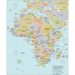
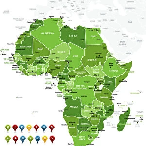
Africa Political Map

![]()
Wall Art and Photo Gifts from Map Marketing
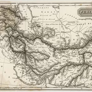
Africa Political Map
The Map Marketing Africa Political Map is an exceptionally clear map of the whole of Africa Including the Saudi Arabian Peninsula, Turkey, Iran and the southern Mediterranean countries. Countries are colour coded with a comprehensive coverage of towns and cities. Also shown are roads, major international airports (with ATA codes), international boundaries, rivers, lakes, deserts and swamps. In addition, the flags of all the African countries are included in an inset box
Media ID 19949233
© Map Marketing Ltd
FEATURES IN THESE COLLECTIONS
> Africa
> Related Images
> Arts
> Landscape paintings
> Waterfall and river artworks
> River artworks
> Asia
> Iran
> Lakes
> Related Images
> Asia
> Iran
> Related Images
> Asia
> Saudi Arabia
> Maps
> Asia
> Saudi Arabia
> Related Images
> Asia
> Turkey
> Lakes
> Related Images
> Asia
> Turkey
> Related Images
> Maps and Charts
> Popular Maps
MADE IN AUSTRALIA
Safe Shipping with 30 Day Money Back Guarantee
FREE PERSONALISATION*
We are proud to offer a range of customisation features including Personalised Captions, Color Filters and Picture Zoom Tools
SECURE PAYMENTS
We happily accept a wide range of payment options so you can pay for the things you need in the way that is most convenient for you
* Options may vary by product and licensing agreement. Zoomed Pictures can be adjusted in the Cart.