Home > North America > United States of America > New York > New York > Maps
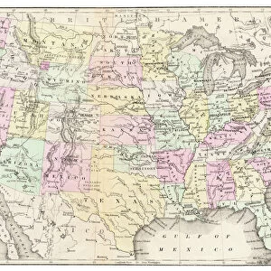
Pacific States USA map 1881

![]()
Wall Art and Photo Gifts from Fine Art Storehouse
Pacific States USA map 1881
Harpers School Geography, New York, Harpers and Brothers, 1881
Unleash your creativity and transform your space into a visual masterpiece!
THEPALMER
Media ID 14756086
© This content is subject to copyright
Arizona California Colorado Montana New Mexico Oregon Pacific Washington Wyoming
FEATURES IN THESE COLLECTIONS
> Fine Art Storehouse
> Map
> Historical Maps
> Fine Art Storehouse
> Map
> USA Maps
> Maps and Charts
> Early Maps
> North America
> Mexico
> Related Images
> North America
> United States of America
> Arizona
> Related Images
> North America
> United States of America
> California
> Related Images
> North America
> United States of America
> Colorado
> Related Images
> North America
> United States of America
> Maps
> North America
> United States of America
> Montana
> Related Images
> North America
> United States of America
> New Mexico
> Related Images
> North America
> United States of America
> New York
> New York
> Maps
> North America
> United States of America
> Oregon
> Related Images
EDITORS COMMENTS
This print showcases a historical gem, the "Pacific States USA map 1881". Extracted from Harpers School Geography, New York, published by Harpers and Brothers in 1881, this piece offers a fascinating glimpse into the past. The meticulously detailed map encompasses states such as Arizona, Colorado, Oregon, Washington, California, Montana, New Mexico, Pacific (Ocean), Wyoming - each intricately outlined with precision. The vintage charm of this artwork transports viewers to an era when these western territories were still emerging frontiers. It serves as a visual time capsule that allows us to reflect on the growth and development of these regions over the years. The delicate lines and intricate labeling provide insight into how geography was perceived during that period. "The Palmer" an artist renowned for their ability to capture historical significance through artistry and attention to detail brings this remarkable piece back to life. Through their skilled hands and keen eye for composition, they have transformed this antique map into a stunning photographic print that is sure to captivate any admirer of history or cartography. Whether displayed in homes or offices alike, this print invites exploration and sparks curiosity about America's westward expansion. Its timeless appeal makes it not only an exquisite decorative addition but also a valuable educational tool for those interested in understanding our nation's geographical evolution.
MADE IN AUSTRALIA
Safe Shipping with 30 Day Money Back Guarantee
FREE PERSONALISATION*
We are proud to offer a range of customisation features including Personalised Captions, Color Filters and Picture Zoom Tools
SECURE PAYMENTS
We happily accept a wide range of payment options so you can pay for the things you need in the way that is most convenient for you
* Options may vary by product and licensing agreement. Zoomed Pictures can be adjusted in the Cart.