Home > Europe > United Kingdom > England > Maps
Ancient Europe under Emporer Augstus (63 BC-14 AD), published 1861
, published 1861")
![]()
Wall Art and Photo Gifts from Fine Art Storehouse
Ancient Europe under Emporer Augstus (63 BC-14 AD), published 1861
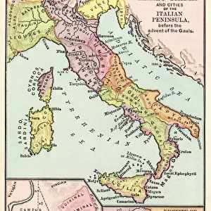
Ancient map of Gaul, Germania and Britannia during the time of the first Roman Emporer Augstus (63 BC - 14 AD). Legend in Latin language. Steel engraving with colored borderlines, published in 1861
Unleash your creativity and transform your space into a visual masterpiece!
Media ID 13666873
© ZU_09
Ancient Rome Augustus Caesar Britannia Empire European Alps German North Sea Region North Atlantic Ocean North Sea Past Roman Steel Engraving Gaul
FEATURES IN THESE COLLECTIONS
> Europe
> Italy
> Lazio
> Rome
> Europe
> United Kingdom
> England
> Maps
> Fine Art Storehouse
> Map
> Historical Maps
> Fine Art Storehouse
> Map
> Italian Maps
> Maps and Charts
> Early Maps
> Maps and Charts
> Italy
EDITORS COMMENTS
This print takes us back in time to Ancient Europe under the reign of Emperor Augustus. Published in 1861, this ancient map showcases Gaul, Germania, and Britannia during the era of the first Roman Emperor. The intricate details are brought to life through a steel engraving technique with colored borderlines. As we delve into this historical masterpiece, we encounter a legend written in Latin language that guides us through the vast territories depicted. From Italy to Germany, France to England, and even beyond towards the European Alps and North Sea region; every corner of this empire is meticulously etched onto the surface. The image transports us into an era where empires were built and civilizations flourished. It serves as a reminder of how far our world has come since those ancient times. With no people present within its borders, it allows us to reflect on our past and appreciate the rich tapestry of history that has shaped our present. This antique photograph captures not only geographical boundaries but also highlights cultural exchanges between different regions during that period. It stands as a testament to human curiosity and exploration throughout time. Whether you are an enthusiast for cartography or simply fascinated by Ancient Rome's legacy, this horizontal print will undoubtedly ignite your imagination as you embark on a journey through centuries gone by.
MADE IN AUSTRALIA
Safe Shipping with 30 Day Money Back Guarantee
FREE PERSONALISATION*
We are proud to offer a range of customisation features including Personalised Captions, Color Filters and Picture Zoom Tools
SECURE PAYMENTS
We happily accept a wide range of payment options so you can pay for the things you need in the way that is most convenient for you
* Options may vary by product and licensing agreement. Zoomed Pictures can be adjusted in the Cart.