Home > Oceania > Solomon Islands > Maps
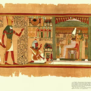
Antique map of British Solomon Islands Protectorate

![]()
Wall Art and Photo Gifts from Fine Art Storehouse
Antique map of British Solomon Islands Protectorate
Unleash your creativity and transform your space into a visual masterpiece!
Hemera Technologies
Media ID 13609537
© Getty Images
Archipelago Coordinates Direction Document Geography Land Legend Location Place Positioning Territory Title Insets Quadrants
FEATURES IN THESE COLLECTIONS
> Fine Art Storehouse
> Map
> Historical Maps
> Maps and Charts
> Early Maps
> Oceania
> Solomon Islands
> Maps
EDITORS COMMENTS
This antique map of the British Solomon Islands Protectorate takes us on a journey through time, offering a glimpse into the rich history and geography of this archipelago. Crafted with precision and care, this archival print showcases the intricate details engraved by Hemera Technologies. The map is adorned with elegant quadrants, each revealing different aspects of the territory's physical geography. Insets provide further insights into specific locations within the protectorate, while a key and legend guide our understanding of symbols and coordinates used throughout. As we immerse ourselves in this vintage masterpiece, we can't help but appreciate its historical significance. It serves as both a document and an art form that captures not only land boundaries but also cultural heritage. The horizontal composition allows us to explore every corner effortlessly, while vibrant colors bring life to previously uncharted territories. This color image transports us back in time without any distractions from modern civilization or human presence. Whether you are an avid cartography enthusiast or simply fascinated by history, this antique map offers a unique opportunity to connect with the past. Let it ignite your curiosity about British Solomon Islands Protectorate's intriguing past as you embark on your own exploration through its beautifully depicted landscapes.
MADE IN AUSTRALIA
Safe Shipping with 30 Day Money Back Guarantee
FREE PERSONALISATION*
We are proud to offer a range of customisation features including Personalised Captions, Color Filters and Picture Zoom Tools
SECURE PAYMENTS
We happily accept a wide range of payment options so you can pay for the things you need in the way that is most convenient for you
* Options may vary by product and licensing agreement. Zoomed Pictures can be adjusted in the Cart.