Home > North America > United States of America > New York > New York > Maps
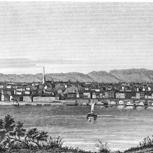
Cincinnati map 1893

![]()
Wall Art and Photo Gifts from Fine Art Storehouse
Cincinnati map 1893
Johnsonas Universal Cyclopedia - Charles Kendall - New York 1893 vol 2
Unleash your creativity and transform your space into a visual masterpiece!
THEPALMER
Media ID 14756542
© This content is subject to copyright
FEATURES IN THESE COLLECTIONS
> Fine Art Storehouse
> Map
> Historical Maps
> Fine Art Storehouse
> Map
> USA Maps
> Maps and Charts
> Early Maps
> North America
> United States of America
> Maps
> North America
> United States of America
> New York
> New York
> Maps
EDITORS COMMENTS
This print takes us back in time to the bustling city of Cincinnati in 1893. The image showcases a meticulously detailed map, sourced from Johnson's Universal Cyclopedia by Charles Kendall, published in New York during that era. As we gaze upon this vintage piece, we are transported to an era when cartography was both an art form and a practical necessity. The map itself is a testament to the craftsmanship and dedication of its creator. Every street, building, and landmark is intricately illustrated with precision and accuracy. It serves as a historical record of Cincinnati's urban landscape at the turn of the 19th century. Through this photograph, THEPALMER skillfully captures not only the beauty of this antique map but also evokes nostalgia for a bygone era. The sepia tones lend an air of authenticity while enhancing our connection to history. As we examine each intricate detail on display - from the winding riverfront to the neatly laid-out streets - we can't help but marvel at how much has changed over time. This snapshot allows us to appreciate how cities evolve and grow throughout generations. Whether you're a history enthusiast or simply captivated by beautiful artwork, this print offers a unique glimpse into Cincinnati's past. It serves as both an educational tool and a stunning decorative piece that will surely spark conversations about urban development and change over time.
MADE IN AUSTRALIA
Safe Shipping with 30 Day Money Back Guarantee
FREE PERSONALISATION*
We are proud to offer a range of customisation features including Personalised Captions, Color Filters and Picture Zoom Tools
SECURE PAYMENTS
We happily accept a wide range of payment options so you can pay for the things you need in the way that is most convenient for you
* Options may vary by product and licensing agreement. Zoomed Pictures can be adjusted in the Cart.