Home > Maps and Charts > Early Maps
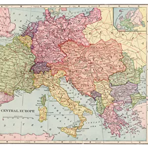
Map of Central Europe 1881

![]()
Wall Art and Photo Gifts from Fine Art Storehouse
Map of Central Europe 1881
A System of Modern Geography designed for the use of schools and academies by Augustus Mitchell - Published by T. H. Butler / Philadelphia 1881
Unleash your creativity and transform your space into a visual masterpiece!
THEPALMER
Media ID 18357231
FEATURES IN THESE COLLECTIONS
> Europe
> Related Images
> Fine Art Storehouse
> Map
> Historical Maps
> Maps and Charts
> Early Maps
EDITORS COMMENTS
In this photo print, we are transported back in time to the year 1881, as we explore a meticulously detailed "Map of Central Europe". This historical artifact was originally featured in Augustus Mitchell's renowned publication, "A System of Modern Geography designed for the use of schools and academies" which aimed to educate and enlighten young minds. The map showcases the intricate borders and boundaries that defined Central Europe during this era. With its rich hues and delicate engravings, it offers a glimpse into the political landscape of a bygone era. From Germany's sprawling territories to Austria-Hungary's vast empire, each country is distinctly outlined with precision. Published by T. H. Butler in Philadelphia, this particular print holds immense value not only for cartography enthusiasts but also for those passionate about history. It serves as a testament to the artistry involved in creating maps before modern technology took over. "ThePALMER" from Fine Art Storehouse has masterfully captured every minute detail of this vintage treasure through their expert photography skills. The composition allows us to appreciate both the grandeur of Central Europe's geography and the intricacies embedded within its borders. This print invites us on an enchanting journey through time while reminding us of how far our understanding of geography has evolved since 1881. It stands as a timeless piece that sparks curiosity and appreciation for both artistry and historical knowledge alike.
MADE IN AUSTRALIA
Safe Shipping with 30 Day Money Back Guarantee
FREE PERSONALISATION*
We are proud to offer a range of customisation features including Personalised Captions, Color Filters and Picture Zoom Tools
SECURE PAYMENTS
We happily accept a wide range of payment options so you can pay for the things you need in the way that is most convenient for you
* Options may vary by product and licensing agreement. Zoomed Pictures can be adjusted in the Cart.