Jigsaw Puzzle > Arts > Artists > B > Augustus Butler
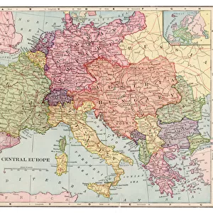
Jigsaw Puzzle : Map of Central Europe 1881


![]()
Jigsaw Puzzles from Fine Art Storehouse
Map of Central Europe 1881
A System of Modern Geography designed for the use of schools and academies by Augustus Mitchell - Published by T. H. Butler / Philadelphia 1881
Unleash your creativity and transform your space into a visual masterpiece!
THEPALMER
Media ID 18357231
Jigsaw Puzzle (500 Pieces)
Discover the historical charm of the past with our exquisite jigsaw puzzle from the Media Storehouse collection. This intriguing puzzle features a detailed map of Central Europe in 1881, taken from the "A System of Modern Geography" published by T.H. Butler in Philadelphia. The map, titled "Map of Central Europe" and created by THEPALMER from the Fine Art Storehouse, offers a captivating glimpse into the geography of the region during that era. Engage in a stimulating and educational puzzle experience while immersing yourself in the rich history of Central Europe. Piece together the intricate details and bring the past to life in your own home.
500 piece puzzles are custom made in Australia and hand-finished on 100% recycled 1.6mm thick laminated puzzle boards. There is a level of repetition in jigsaw shapes with each matching piece away from its pair. The completed puzzle measures 40x51cm and is delivered packaged in an attractive presentation box specially designed to fit most mail slots with a unique magnetic lid
Jigsaw Puzzles are an ideal gift for any occasion
Estimated Product Size is 50.7cm x 40.3cm (20" x 15.9")
These are individually made so all sizes are approximate
Artwork printed orientated as per the preview above, with landscape (horizontal) or portrait (vertical) orientation to match the source image.
FEATURES IN THESE COLLECTIONS
> Fine Art Storehouse
> Map
> Historical Maps
> Arts
> Artists
> B
> Augustus Butler
> Europe
> Related Images
> Maps and Charts
> Related Images
EDITORS COMMENTS
In this photo print, we are transported back in time to the year 1881, as we explore a meticulously detailed "Map of Central Europe". This historical artifact was originally featured in Augustus Mitchell's renowned publication, "A System of Modern Geography designed for the use of schools and academies" which aimed to educate and enlighten young minds. The map showcases the intricate borders and boundaries that defined Central Europe during this era. With its rich hues and delicate engravings, it offers a glimpse into the political landscape of a bygone era. From Germany's sprawling territories to Austria-Hungary's vast empire, each country is distinctly outlined with precision. Published by T. H. Butler in Philadelphia, this particular print holds immense value not only for cartography enthusiasts but also for those passionate about history. It serves as a testament to the artistry involved in creating maps before modern technology took over. "ThePALMER" from Fine Art Storehouse has masterfully captured every minute detail of this vintage treasure through their expert photography skills. The composition allows us to appreciate both the grandeur of Central Europe's geography and the intricacies embedded within its borders. This print invites us on an enchanting journey through time while reminding us of how far our understanding of geography has evolved since 1881. It stands as a timeless piece that sparks curiosity and appreciation for both artistry and historical knowledge alike.
MADE IN AUSTRALIA
Safe Shipping with 30 Day Money Back Guarantee
FREE PERSONALISATION*
We are proud to offer a range of customisation features including Personalised Captions, Color Filters and Picture Zoom Tools
SECURE PAYMENTS
We happily accept a wide range of payment options so you can pay for the things you need in the way that is most convenient for you
* Options may vary by product and licensing agreement. Zoomed Pictures can be adjusted in the Cart.