Framed Print > Europe > Italy > Lakes > Lake Garda
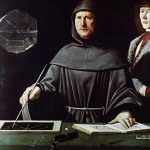
Framed Print : Map of Old and New Virginia, 1646-47


![]()
Framed Photos From Fine Art Finder
Map of Old and New Virginia, 1646-47
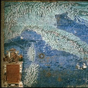
3786721 Map of Old and New Virginia, 1646-47; (add.info.: Map of Old and New Virginia - published in Dudleys Dell Arcano del Mare, 1646- 47. Sir Robert Dudley (1574-1649) was an English explorer and cartographer who lived in Italy in the 17th century and styled himself as Duke of Northumberland; son of Robert Dudley, Earl of Leicester American colonies.
Old Decorative Maps and Charts by Arthur L. Humphreys, 1926. Plate 56); Lebrecht History
Media ID 23007942
© Lebrecht History / Bridgeman Images
Acconciatura Battistero Bin Ass1 Cartographer Ceiling Countries Dull Gret Earth Earth Globe Globe Lake Garda Seventeenth Terrestrial Zebra Four Elements
13.5"x11.5" (34x29cm) Premium Frame
Discover the rich history of Virginia with our stunning Framed Print of the Map of Old and New Virginia from Bridgeman Images. Dating back to 1646-47, this exquisite map was originally published in Dudley's Dell Arcano del Mare. Add an air of sophistication and historical charm to your home or office with this beautiful piece of fine art. The intricate details of the map are brought to life with our high-quality framing, making it a perfect conversation starter and a unique addition to any collection. Travel back in time and explore the early cartography of Virginia with our Framed Print of the Map of Old and New Virginia.
Framed and mounted 9x7 print. Professionally handmade full timber moulded frames are finished off with framers tape and come with a hanging solution on the back. Outer dimensions are 13.5x11.5 inches (34x29cm). Quality timber frame frame moulding (20mm wide and 30mm deep) with frame colours in your choice of black, white, or raw oak and a choice of black or white card mounts. Frames have a perspex front providing a virtually unbreakable glass-like finish which is easily cleaned with a damp cloth.
Contemporary Framed and Mounted Prints - Professionally Made and Ready to Hang
Estimated Image Size (if not cropped) is 21.4cm x 21.4cm (8.4" x 8.4")
Estimated Product Size is 29.2cm x 34cm (11.5" x 13.4")
These are individually made so all sizes are approximate
Artwork printed orientated as per the preview above, with landscape (horizontal) or portrait (vertical) orientation to match the source image.
FEATURES IN THESE COLLECTIONS
> Fine Art Finder
> Artists
> Arthur Rackham
> Fine Art Finder
> Maps (celestial & Terrestrial)
> Arts
> Art Movements
> Renaissance Art
> Europe
> Italy
> Lakes
> Lake Garda
> Europe
> Italy
> Lakes
> Related Images
> Europe
> United Kingdom
> England
> Northumberland
> Related Images
> Historic
> Renaissance art
> Italian Renaissance art
EDITORS COMMENTS
This print showcases the "Map of Old and New Virginia, 1646-47" a remarkable piece published in Dudleys Dell Arcano del Mare. Created by Sir Robert Dudley, an English explorer and cartographer who resided in Italy during the 17th century, this map offers a glimpse into the early American colonies. The intricate details and decorative elements make this map truly enchanting. It transports us back to a time when cartography was both scientific and artistic. The delicate illustrations of countries, globes, and even the four elements add depth to this historical masterpiece. As we explore this map further, we are reminded of the significant role it played in shaping our understanding of America's past. From its depiction of Old Virginia to New Virginia, it provides valuable insights into how these regions evolved over time. The inclusion of Sir Robert Dudley's personal title as Duke of Northumberland adds an intriguing layer to his identity as a cartographer. His connection with England's aristocracy intertwines with his passion for exploration and mapping. Through this print from Fine Art Finder, we can appreciate not only the craftsmanship behind this 17th-century work but also its significance in documenting America's history. It serves as a testament to human curiosity and our desire to understand our world better through artistry and science alike.
MADE IN AUSTRALIA
Safe Shipping with 30 Day Money Back Guarantee
FREE PERSONALISATION*
We are proud to offer a range of customisation features including Personalised Captions, Color Filters and Picture Zoom Tools
SECURE PAYMENTS
We happily accept a wide range of payment options so you can pay for the things you need in the way that is most convenient for you
* Options may vary by product and licensing agreement. Zoomed Pictures can be adjusted in the Basket.