Framed Print > North America > Canada > Maps
Framed Print : 1883 Dominion Of Canada Map


![]()
Framed Photos from Fine Art Storehouse
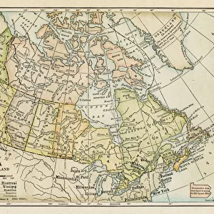
1883 Dominion Of Canada Map
1883 Dominion Of Canada Map/ British America
Unleash your creativity and transform your space into a visual masterpiece!
benoitb
Media ID 19332769
© benoitb
13.5"x11.5" (34x29cm) Premium Frame
Discover the rich history of Canada with our exquisite Framed Print of the 1883 Dominion of Canada Map from Benoitb's collection at Media Storehouse. This vintage map, originally titled "British America," beautifully depicts the political divisions of Canada during its formative years. The intricate details and antique charm of this map are sure to add an elegant touch to any room. Each Framed Print is meticulously crafted with premium materials to ensure long-lasting beauty and protection against fading. Elevate your home or office decor with this unique and captivating piece of Canadian history.
Framed and mounted 9x7 print. Professionally handmade full timber moulded frames are finished off with framers tape and come with a hanging solution on the back. Outer dimensions are 13.5x11.5 inches (34x29cm). Quality timber frame frame moulding (20mm wide and 30mm deep) with frame colours in your choice of black, white, or raw oak and a choice of black or white card mounts. Frames have a perspex front providing a virtually unbreakable glass-like finish which is easily cleaned with a damp cloth.
Contemporary Framed and Mounted Prints - Professionally Made and Ready to Hang
Estimated Image Size (if not cropped) is 21.4cm x 21.4cm (8.4" x 8.4")
Estimated Product Size is 34cm x 29.2cm (13.4" x 11.5")
These are individually made so all sizes are approximate
Artwork printed orientated as per the preview above, with landscape (horizontal) or portrait (vertical) orientation to match the source image.
FEATURES IN THESE COLLECTIONS
> Fine Art Storehouse
> Map
> Historical Maps
> Maps and Charts
> Related Images
> North America
> Canada
> Maps
> North America
> Canada
> Related Images
EDITORS COMMENTS
This print showcases the intricate details of the 1883 Dominion of Canada Map, a true masterpiece in cartography. With its retro revival aesthetic, this piece takes us back to an era when map-making was both an art form and a scientific endeavor. The artist, Benoitb, has skillfully captured every contour and boundary line with precision and finesse. The map itself is a fascinating glimpse into the past, depicting British America during that time period. From the majestic Mt Athabasca to the vast expanses of Labrador and the Gulf of St Lawrence, this map offers a comprehensive view of Canada's geographical landscape over a century ago. As we gaze upon this print, we are transported to an age where exploration and discovery were at their peak. It serves as a reminder of our rich history and how far we have come as a nation. The attention to detail in this artwork is truly remarkable; each stroke tells a story about our country's heritage. Whether you're an avid collector or simply appreciate fine art, this print is sure to captivate your imagination. Hang it proudly on your wall or gift it to someone who shares your passion for history and geography. Let this stunning piece be a conversation starter that sparks curiosity about our past while adding timeless beauty to any space it graces.
MADE IN AUSTRALIA
Safe Shipping with 30 Day Money Back Guarantee
FREE PERSONALISATION*
We are proud to offer a range of customisation features including Personalised Captions, Color Filters and Picture Zoom Tools
SECURE PAYMENTS
We happily accept a wide range of payment options so you can pay for the things you need in the way that is most convenient for you
* Options may vary by product and licensing agreement. Zoomed Pictures can be adjusted in the Cart.