Framed Print > Fine Art Storehouse > Map
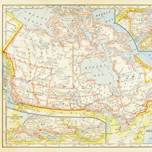
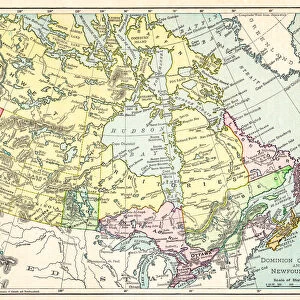
Framed Print : Dominion of Canada map 1886


![]()
Framed Photos from Fine Art Storehouse
Dominion of Canada map 1886
Dominion of Canada map Maps Monteith Physical Geography 1886
Unleash your creativity and transform your space into a visual masterpiece!
THEPALMER
Media ID 14756960
© This content is subject to copyright
13.5"x11.5" (34x29cm) Premium Frame
Step back in time with the Dominion of Canada Map 1886 from Media Storehouse's Framed Prints collection. This stunning piece of historical cartography is brought to you by THEPALMER, a renowned name in Fine Art Storehouse. The map, originally published by Monteith's Physical Geography in 1886, showcases the Dominion of Canada during an era of significant growth and expansion. Each detail, from the meticulously drawn borders to the intricate labeling, is brought to life in high-quality print and beautifully framed. Add a touch of history and sophistication to your space with this exquisite and authentic representation of a bygone era. Order your Dominion of Canada Map 1886 Framed Print today and let the story of Canada's past unfold in your home.
Framed and mounted 9x7 print. Professionally handmade full timber moulded frames are finished off with framers tape and come with a hanging solution on the back. Outer dimensions are 13.5x11.5 inches (34x29cm). Quality timber frame frame moulding (20mm wide and 30mm deep) with frame colours in your choice of black, white, or raw oak and a choice of black or white card mounts. Frames have a perspex front providing a virtually unbreakable glass-like finish which is easily cleaned with a damp cloth.
Contemporary Framed and Mounted Prints - Professionally Made and Ready to Hang
Estimated Image Size (if not cropped) is 21.4cm x 21.4cm (8.4" x 8.4")
Estimated Product Size is 34cm x 29.2cm (13.4" x 11.5")
These are individually made so all sizes are approximate
Artwork printed orientated as per the preview above, with landscape (horizontal) or portrait (vertical) orientation to match the source image.
FEATURES IN THESE COLLECTIONS
> Fine Art Storehouse
> Map
> Historical Maps
EDITORS COMMENTS
In this print titled "Dominion of Canada map 1886" we are transported back in time to the late 19th century. The image showcases a meticulously detailed map, created by Monteith Physical Geography in the year 1886. This historical artifact offers us a glimpse into the vast Dominion of Canada during its early years. The intricate lines and delicate shading on the map highlight the immense geographical expanse that constituted Canada at that time. From coast to coast, we witness an array of provinces and territories coming together under one unified nation. It is fascinating to observe how boundaries have evolved since then, as well as marvel at the sheer size and diversity of this great land. "ThePALMER" has skillfully captured this antique piece with utmost precision, allowing us to appreciate every fine detail preserved within it. The monochrome palette adds a timeless quality to the photograph, enhancing our connection with history. This print from Fine Art Storehouse serves as more than just an aesthetic piece; it acts as a portal through which we can explore our past. Whether you are a history enthusiast or simply intrigued by cartography, this artwork will undoubtedly spark curiosity about Canada's rich heritage and its journey towards becoming the nation we know today.
MADE IN AUSTRALIA
Safe Shipping with 30 Day Money Back Guarantee
FREE PERSONALISATION*
We are proud to offer a range of customisation features including Personalised Captions, Color Filters and Picture Zoom Tools
SECURE PAYMENTS
We happily accept a wide range of payment options so you can pay for the things you need in the way that is most convenient for you
* Options may vary by product and licensing agreement. Zoomed Pictures can be adjusted in the Cart.