Framed Print > Fine Art Storehouse > Map
Framed Print : Historical map of the United States in 1854


![]()
Framed Photos from Fine Art Storehouse
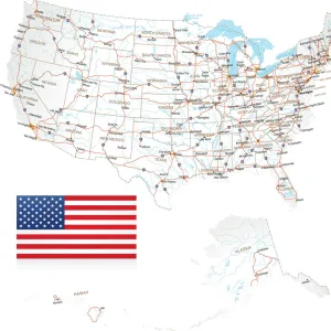
Historical map of the United States in 1854
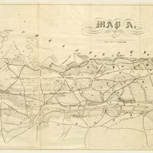
Historical map of the United States in 1854 - Scanned 1887 Engraving
Unleash your creativity and transform your space into a visual masterpiece!
benoitb
Media ID 14756146
© This content is subject to copyright
A2 Premium Frame with A3 Poster
Step back in time with our Historical Map of the United States in 1854 from Media Storehouse's Framed Prints collection. This stunning, vintage map, sourced from the Fine Art Storehouse, showcases intricate detail and accurate representation of the United States as it existed prior to the Civil War. The 1887 engraving adds an authentic, antique charm to any room, making it a perfect addition to your home or office decor. Bring history to life with this unique piece of art.
Premium Paradise Wooden Range A2 Premium Poster Frame (62x45cm) with A3 Poster (42x30cm) and mounted behind a white matt board to make your photo really stand out. FSC Certified and Rainforest Alliance Certified for environmental, social, and economic sustainably. High transparency tempered glass window with a smooth finished frame. Great for filling empty walls, decorating blank spaces, or creating eye-catching gallery walls. Frames arrive ready to hang. Sent with secure, protective packaging. Smooth wooden veneer mimics the real wood look and feel with ultra-durable scratch resistance tempered glass.
Contemporary Framed and Mounted Prints - Professionally Made and Ready to Hang
Estimated Image Size (if not cropped) is 40.4cm x 40.4cm (15.9" x 15.9")
Estimated Product Size is 62cm x 44.6cm (24.4" x 17.6")
These are individually made so all sizes are approximate
Artwork printed orientated as per the preview above, with landscape (horizontal) or portrait (vertical) orientation to match the source image.
FEATURES IN THESE COLLECTIONS
> Fine Art Storehouse
> Map
> Historical Maps
EDITORS COMMENTS
This print showcases a historical map of the United States in 1854, beautifully scanned from an engraving dating back to 1887. Created by the talented artist Benoitb, this piece takes us on a journey through time, offering a glimpse into America's past. The intricate details and artistry of this map transport us to an era when the nation was still taking shape and expanding its territories. It provides a fascinating snapshot of how the United States appeared over 150 years ago, with each state clearly outlined and labeled. As we examine this remarkable artwork, we are reminded of the rich history that shaped our country. From British America to independent states united under one flag, it is evident that every inch of land represented here carries stories untold. The muted color palette adds a touch of vintage charm to this print, further enhancing its nostalgic appeal. Whether displayed in homes or educational institutions, this piece serves as both decor and educational tool - inviting viewers to explore and reflect upon the nation's roots. Benoitb's meticulous attention to detail brings life to every stroke on this historical map print. It serves as a reminder that even within modern times, there is much wisdom and beauty to be found by delving into our collective pasts.
MADE IN AUSTRALIA
Safe Shipping with 30 Day Money Back Guarantee
FREE PERSONALISATION*
We are proud to offer a range of customisation features including Personalised Captions, Color Filters and Picture Zoom Tools
SECURE PAYMENTS
We happily accept a wide range of payment options so you can pay for the things you need in the way that is most convenient for you
* Options may vary by product and licensing agreement. Zoomed Pictures can be adjusted in the Cart.