Framed Print > Maps and Charts > Americas
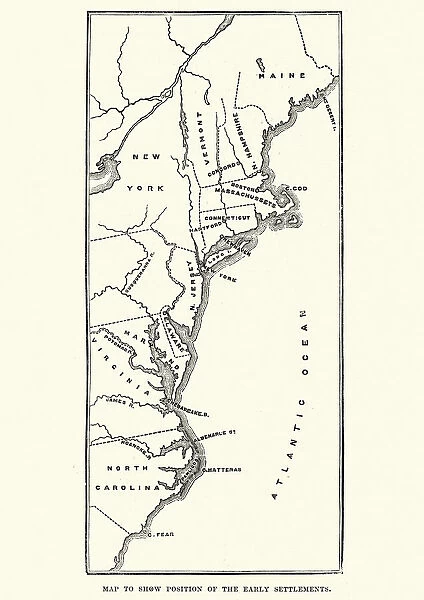
Framed Print : Map of the early settlements in North America
![]()

Framed Photos from Fine Art Storehouse
Map of the early settlements in North America
Vintage engraving of Map of the early settlements in North America
Unleash your creativity and transform your space into a visual masterpiece!
duncan1890
Media ID 18106643
© of Duncan P Walker
A2 Premium Frame with A3 Poster
Step back in time with our vintage engraving, "Map of the Early Settlements in North America" by duncan1890 from our Media Storehouse Framed Prints collection. This exquisite piece showcases the rich history of North American exploration and colonization. The intricate detail of the engraving brings the early settlements to life, making it a stunning addition to any home or office. Our high-quality Framed Prints are made to last, ensuring that this piece of history remains a beautiful conversation starter for generations to come. Order yours today and let the stories of the past inspire your present.
Premium Paradise Wooden Range A2 Premium Poster Frame (62x45cm) with A3 Poster (42x30cm) and mounted behind a white matt board to make your photo really stand out. FSC Certified and Rainforest Alliance Certified for environmental, social, and economic sustainably. High transparency tempered glass window with a smooth finished frame. Great for filling empty walls, decorating blank spaces, or creating eye-catching gallery walls. Frames arrive ready to hang. Sent with secure, protective packaging. Smooth wooden veneer mimics the real wood look and feel with ultra-durable scratch resistance tempered glass.
Contemporary Framed and Mounted Prints - Professionally Made and Ready to Hang
Estimated Image Size (if not cropped) is 40.4cm x 40.4cm (15.9" x 15.9")
Estimated Product Size is 44.6cm x 62cm (17.6" x 24.4")
These are individually made so all sizes are approximate
Artwork printed orientated as per the preview above, with landscape (horizontal) or portrait (vertical) orientation to match the source image.
FEATURES IN THESE COLLECTIONS
> Fine Art Storehouse
> Map
> Historical Maps
> Maps and Charts
> Early Maps
> Maps and Charts
> Related Images
> North America
> Related Images
EDITORS COMMENTS
This vintage engraving of a "Map of the early settlements in North America" takes us on a journey back in time, offering a glimpse into the rich history and exploration that shaped this vast continent. Created by the talented artist duncan1890, this print from Fine Art Storehouse is an exquisite piece that captures the essence of discovery and colonization. As we gaze upon this intricately detailed map, our eyes are immediately drawn to the intricate lines depicting coastlines, rivers, and mountain ranges. Each settlement is marked with precision, showcasing how pioneers ventured across uncharted territories to establish new communities. The delicate engravings reveal their determination and resilience as they pushed boundaries and overcame countless obstacles. The warm sepia tones evoke a sense of nostalgia, transporting us to an era when cartography was both scientific endeavor and artistic expression. This print invites us to ponder upon the courage it took for these early settlers to embark on perilous journeys into unknown lands. Beyond its historical significance lies an aesthetic appeal that captivates art enthusiasts. The fine details invite closer inspection; one can almost imagine tracing their fingers along each contour line or exploring every nook and cranny depicted on this antique map. Whether you are a history enthusiast or simply appreciate beautiful artwork, this vintage engraving offers both intellectual curiosity and visual delight. It serves as a reminder of our collective past while also celebrating human ingenuity in navigating uncharted waters - quite literally!
MADE IN AUSTRALIA
Safe Shipping with 30 Day Money Back Guarantee
FREE PERSONALISATION*
We are proud to offer a range of customisation features including Personalised Captions, Color Filters and Picture Zoom Tools
SECURE PAYMENTS
We happily accept a wide range of payment options so you can pay for the things you need in the way that is most convenient for you
* Options may vary by product and licensing agreement. Zoomed Pictures can be adjusted in the Cart.


