Framed Print > Fine Art Storehouse > Map
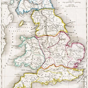
Framed Print : Map of England and Wales in 1878


![]()
Framed Photos from Fine Art Storehouse
Map of England and Wales in 1878
Encyclopedia Britannica 9th Edition Vol XII Philadelphia j.M. Stoddart & Co 1881
Unleash your creativity and transform your space into a visual masterpiece!
THEPALMER
Media ID 14756282
© This content is subject to copyright
Great Britain Ireland Scotland Wales
21.5"x17.5" (55x44cm) Premium Frame
Step back in time with our exquisite framed print of "Map of England and Wales in 1878" by THEPALMER from the Fine Art Storehouse at Media Storehouse. This captivating map, taken from the Encyclopedia Britannica 9th Edition Vol XII published by J.M. Stoddart & Co in 1881, offers a fascinating glimpse into the historical geography of England and Wales over a century ago. The intricate details and vintage charm of this antique map are beautifully preserved in our high-quality framed print, making it an exceptional addition to any home or office space. Impress your guests with this unique and educational piece of history.
Framed and mounted 17x12 print. Professionally handmade full timber moulded frames are finished off with framers tape and come with a hanging solution on the back. Outer dimensions are 21.5x17.5 inches (546x444mm). Quality timber frame frame moulding (20mm wide and 30mm deep) with frame colours in your choice of black, white, or raw oak and a choice of black or white card mounts. Frames have a perspex front providing a virtually unbreakable glass-like finish which is easily cleaned with a damp cloth.
Contemporary Framed and Mounted Prints - Professionally Made and Ready to Hang
Estimated Image Size (if not cropped) is 41.8cm x 41.8cm (16.5" x 16.5")
Estimated Product Size is 44.4cm x 54.6cm (17.5" x 21.5")
These are individually made so all sizes are approximate
Artwork printed orientated as per the preview above, with landscape (horizontal) or portrait (vertical) orientation to match the source image.
FEATURES IN THESE COLLECTIONS
> Fine Art Storehouse
> Map
> Historical Maps
EDITORS COMMENTS
This print showcases a remarkable piece of history - the Map of England and Wales in 1878. Originally featured in the Encyclopedia Britannica's 9th Edition, Volume XII, published by J. M. Stoddart & Co in Philadelphia back in 1881, this map offers a fascinating glimpse into the past. With intricate details and precise cartography, this vintage map takes us on a journey through time to explore the geographical landscape of Great Britain. From the rolling hills of Scotland to the picturesque countryside of Wales and Ireland, every region is meticulously depicted with accuracy and artistry. The craftsmanship displayed in this print is truly exceptional. The fine lines and delicate shading bring life to each city, town, river, and mountain range represented on the map. It serves as a testament to both historical accuracy and artistic skill. As we gaze upon this magnificent artwork by THEPALMER from Fine Art Storehouse, we can't help but be transported back to an era long gone. It evokes feelings of nostalgia for simpler times when maps were cherished possessions that guided explorers through uncharted territories. Whether you're an avid historian or simply appreciate beautiful works of art, this Map of England and Wales print will undoubtedly captivate your imagination while serving as a stunning addition to any collection or decor style.
MADE IN AUSTRALIA
Safe Shipping with 30 Day Money Back Guarantee
FREE PERSONALISATION*
We are proud to offer a range of customisation features including Personalised Captions, Color Filters and Picture Zoom Tools
SECURE PAYMENTS
We happily accept a wide range of payment options so you can pay for the things you need in the way that is most convenient for you
* Options may vary by product and licensing agreement. Zoomed Pictures can be adjusted in the Cart.