Framed Print > Historic > Ancient civilizations > Ancient Greece > Greek history
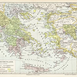
Framed Print : Map of Greece 1896


![]()
Framed Photos from Fine Art Storehouse
Map of Greece 1896
Andres Allgemeiner Handatlas - Bielefeld und Leipzig 1896
Unleash your creativity and transform your space into a visual masterpiece!
THEPALMER
Media ID 18356861
A2 Premium Frame with A3 Poster
Discover the rich history of Greece with our exquisite framed print of the "Map of Greece 1896" by THEPALMER from our Media Storehouse Fine Art collection. This intricately detailed map, published in Andres Allgemeiner Handatlas from Bielefeld and Leipzig, showcases the political boundaries and geographical features of Greece during that era. Each print comes elegantly framed, adding a touch of historical charm to your space. Transport yourself back in time and enhance your decor with this captivating piece of cartographical art.
Premium Paradise Wooden Range A2 Premium Poster Frame (62x45cm) with A3 Poster (42x30cm) and mounted behind a white matt board to make your photo really stand out. FSC Certified and Rainforest Alliance Certified for environmental, social, and economic sustainably. High transparency tempered glass window with a smooth finished frame. Great for filling empty walls, decorating blank spaces, or creating eye-catching gallery walls. Frames arrive ready to hang. Sent with secure, protective packaging. Smooth wooden veneer mimics the real wood look and feel with ultra-durable scratch resistance tempered glass.
Contemporary Framed and Mounted Prints - Professionally Made and Ready to Hang
Estimated Image Size (if not cropped) is 40.4cm x 40.4cm (15.9" x 15.9")
Estimated Product Size is 62cm x 44.6cm (24.4" x 17.6")
These are individually made so all sizes are approximate
Artwork printed orientated as per the preview above, with landscape (horizontal) or portrait (vertical) orientation to match the source image.
FEATURES IN THESE COLLECTIONS
> Fine Art Storehouse
> Map
> Historical Maps
> Europe
> Greece
> Related Images
> Historic
> Ancient civilizations
> Ancient Greece
> Greek history
> Maps and Charts
> Related Images
EDITORS COMMENTS
This print showcases a rare gem from the past, presenting the "Map of Greece 1896" as depicted in Andres Allgemeiner Handatlas - Bielefeld und Leipzig 1896. A true testament to historical cartography, this piece takes us back to a time when maps were meticulously crafted by hand and served as gateways to unexplored territories. The intricate details of this map transport us to late 19th-century Greece, offering a glimpse into its rich cultural heritage and geographical marvels. From the rugged mountain ranges that dominate its landscape to the meandering rivers that shape its valleys, every contour is beautifully captured on this vintage masterpiece. As we delve deeper into this artwork, our eyes are drawn towards significant landmarks such as Athens with its iconic Acropolis standing tall amidst bustling city life. The ancient ruins scattered across the land remind us of Greece's profound influence on Western civilization and evoke an undeniable sense of awe. Expertly preserved by THEPALMER, this print allows us to appreciate not only the artistry behind historical mapping but also serves as a reminder of how far we have come in terms of technological advancements. It invites us to reflect upon our own place in history while celebrating the enduring beauty and timeless allure of Greece.
MADE IN AUSTRALIA
Safe Shipping with 30 Day Money Back Guarantee
FREE PERSONALISATION*
We are proud to offer a range of customisation features including Personalised Captions, Color Filters and Picture Zoom Tools
SECURE PAYMENTS
We happily accept a wide range of payment options so you can pay for the things you need in the way that is most convenient for you
* Options may vary by product and licensing agreement. Zoomed Pictures can be adjusted in the Cart.