Framed Print > Fine Art Storehouse > Map
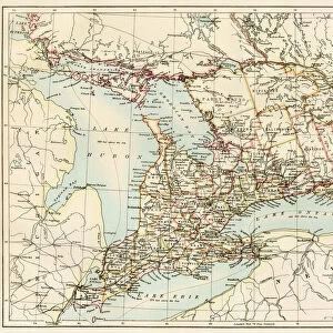
Framed Print : Ontario Cabada map 1884


![]()
Framed Photos from Fine Art Storehouse
Ontario Cabada map 1884
Encyclopedia Britannica 9th Edition New York Charles Scribners and Sonsl 1884 Vol XVII
Unleash your creativity and transform your space into a visual masterpiece!
THEPALMER
Media ID 14756698
© This content is subject to copyright
A2 Premium Frame with A3 Poster
Step back in time with our exquisite Framed Print of the "Ontario Map 1884" by THEPALMER from the Fine Art Storehouse collection. This historic map, originally published in the Encyclopedia Britannica 9th Edition by Charles Scribners and Sons in New York, showcases Ontario's geography during a fascinating era. The intricate details and vintage charm of this beautifully preserved map are sure to make a captivating addition to any home or office decor. Immerse yourself in history and add a touch of timeless elegance to your space with this unique Framed Print from Media Storehouse.
Premium Paradise Wooden Range A2 Premium Poster Frame (62x45cm) with A3 Poster (42x30cm) and mounted behind a white matt board to make your photo really stand out. FSC Certified and Rainforest Alliance Certified for environmental, social, and economic sustainably. High transparency tempered glass window with a smooth finished frame. Great for filling empty walls, decorating blank spaces, or creating eye-catching gallery walls. Frames arrive ready to hang. Sent with secure, protective packaging. Smooth wooden veneer mimics the real wood look and feel with ultra-durable scratch resistance tempered glass.
Contemporary Framed and Mounted Prints - Professionally Made and Ready to Hang
Estimated Image Size (if not cropped) is 40.4cm x 40.4cm (15.9" x 15.9")
Estimated Product Size is 62cm x 44.6cm (24.4" x 17.6")
These are individually made so all sizes are approximate
Artwork printed orientated as per the preview above, with landscape (horizontal) or portrait (vertical) orientation to match the source image.
FEATURES IN THESE COLLECTIONS
> Fine Art Storehouse
> Map
> Historical Maps
EDITORS COMMENTS
This print showcases a historical gem, the "Ontario Canada map 1884" sourced from the esteemed Encyclopedia Britannica 9th Edition. Published in New York by Charles Scribners and Sons in 1884, this remarkable piece of cartographic art is featured in Volume XVII. Crafted with meticulous detail and precision, it offers a fascinating glimpse into Ontario's past. The map itself is an intricate tapestry of lines, colors, and symbols that beautifully depict the sprawling province of Ontario during the late 19th century. From its vast forests to its meandering rivers and picturesque lakeshores, every corner of this Canadian region is meticulously illustrated on this vintage masterpiece. Expertly captured by THEPALMER and brought to life through Fine Art Storehouse's impeccable printing techniques, this print exudes an air of nostalgia while simultaneously serving as a testament to human curiosity and exploration. It invites viewers to embark on a visual journey back in time when maps were cherished artifacts that unfolded stories about lands yet undiscovered. Whether you are an avid history enthusiast or simply appreciate fine artistry, this Ontario Canada map from 1884 will undoubtedly captivate your imagination. Hang it proudly on your wall or gift it to someone who shares your passion for heritage; either way, let it transport you to an era long gone but forever preserved within these delicate contours and vibrant hues.
MADE IN AUSTRALIA
Safe Shipping with 30 Day Money Back Guarantee
FREE PERSONALISATION*
We are proud to offer a range of customisation features including Personalised Captions, Color Filters and Picture Zoom Tools
SECURE PAYMENTS
We happily accept a wide range of payment options so you can pay for the things you need in the way that is most convenient for you
* Options may vary by product and licensing agreement. Zoomed Pictures can be adjusted in the Cart.