Framed Print > North America > United States of America > New York > New York > Maps
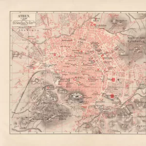
Framed Print : South America map of 1869


![]()
Framed Photos from Fine Art Storehouse
South America map of 1869
Cornells Grammar School Geography By S.S. Cornell - New York 1869
Unleash your creativity and transform your space into a visual masterpiece!
THEPALMER
Media ID 18106815
© 2014 Roberto Adrian Photography
13.5"x11.5" (34x29cm) Premium Frame
Step back in time with our exquisite framed print of the South America map from the Cornells Grammar School Geography textbook published in New York in 1869. This beautiful piece, sourced from THEPALMER's Fine Art Storehouse, showcases intricate detail and historical accuracy. The map provides a fascinating glimpse into the geographical knowledge of the past, making it a captivating addition to any home or office space. Bring history to life with this unique and authentic framed print.
Framed and mounted 9x7 print. Professionally handmade full timber moulded frames are finished off with framers tape and come with a hanging solution on the back. Outer dimensions are 13.5x11.5 inches (34x29cm). Quality timber frame frame moulding (20mm wide and 30mm deep) with frame colours in your choice of black, white, or raw oak and a choice of black or white card mounts. Frames have a perspex front providing a virtually unbreakable glass-like finish which is easily cleaned with a damp cloth.
Contemporary Framed and Mounted Prints - Professionally Made and Ready to Hang
Estimated Image Size (if not cropped) is 21.4cm x 21.4cm (8.4" x 8.4")
Estimated Product Size is 29.2cm x 34cm (11.5" x 13.4")
These are individually made so all sizes are approximate
Artwork printed orientated as per the preview above, with landscape (horizontal) or portrait (vertical) orientation to match the source image.
FEATURES IN THESE COLLECTIONS
> Fine Art Storehouse
> Map
> Historical Maps
> Maps and Charts
> Related Images
> North America
> United States of America
> New York
> New York
> Maps
> North America
> United States of America
> New York
> Related Images
> South America
> Related Images
EDITORS COMMENTS
This print takes us back in time to the year 1869, showcasing a meticulously detailed map of South America. A relic from the past, this piece is extracted from "Cornells Grammar School Geography" by S. S. Cornell, published in New York during that era. The map itself serves as a testament to the artistry and precision of cartographers of yesteryears. The intricate lines and delicate shading on this vintage map effortlessly transport us to a time when exploration and discovery were at their peak. Every contour of the continent is carefully etched onto paper, revealing an array of geographical features - majestic mountain ranges, winding rivers, dense forests, and vast plains. As we immerse ourselves in this historical artifact captured by THEPALMER for Fine Art Storehouse, we can't help but marvel at how much South America has transformed over the centuries. This snapshot provides not only a glimpse into its physical landscape but also offers insight into how our understanding of geography has evolved. Whether you are an avid history enthusiast or simply captivated by the beauty found within maps themselves, this print allows you to own a piece of history while igniting your imagination with tales from times long gone. Let it serve as a reminder that even though borders may shift and civilizations rise and fall, there will always be something timeless about exploring our world through artful cartography.
MADE IN AUSTRALIA
Safe Shipping with 30 Day Money Back Guarantee
FREE PERSONALISATION*
We are proud to offer a range of customisation features including Personalised Captions, Color Filters and Picture Zoom Tools
SECURE PAYMENTS
We happily accept a wide range of payment options so you can pay for the things you need in the way that is most convenient for you
* Options may vary by product and licensing agreement. Zoomed Pictures can be adjusted in the Cart.