Framed Print > Maps and Charts > Americas
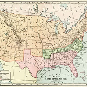
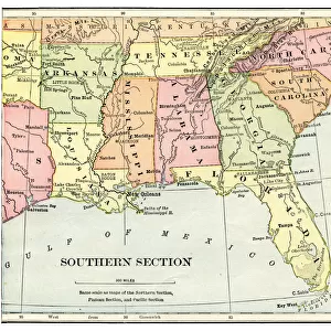
Framed Print : Southern Confederacy Map 1895


![]()
Framed Photos from Fine Art Storehouse
Southern Confederacy Map 1895
Map from " A History of the United States for America. The Confederate States of America, commonly referred to as the Confederacy, was an unrecognized republic in North America that existed from 1861 to 1865
Unleash your creativity and transform your space into a visual masterpiece!
THEPALMER
Media ID 19916133
© A 2014 Roberto Adrian Photography
A2 Premium Frame with A3 Poster
Step back in time with our exquisite Framed Print of the Southern Confederacy Map 1895 from THEPALMER's collection at Media Storehouse. This captivating piece, originally from "A History of the United States for America. The Confederate States of America," adds a rich historical touch to any room. The intricate details of the map, showcasing the territories of the Confederate States, are beautifully preserved in this high-quality print. The frame, with its elegant design, complements the map perfectly and enhances its timeless appeal. Bring a piece of American history into your home or office with this striking Framed Print from Fine Art Storehouse.
Premium Paradise Wooden Range A2 Premium Poster Frame (62x45cm) with A3 Poster (42x30cm) and mounted behind a white matt board to make your photo really stand out. FSC Certified and Rainforest Alliance Certified for environmental, social, and economic sustainably. High transparency tempered glass window with a smooth finished frame. Great for filling empty walls, decorating blank spaces, or creating eye-catching gallery walls. Frames arrive ready to hang. Sent with secure, protective packaging. Smooth wooden veneer mimics the real wood look and feel with ultra-durable scratch resistance tempered glass.
Contemporary Framed and Mounted Prints - Professionally Made and Ready to Hang
Estimated Image Size (if not cropped) is 40.4cm x 40.4cm (15.9" x 15.9")
Estimated Product Size is 62cm x 44.6cm (24.4" x 17.6")
These are individually made so all sizes are approximate
Artwork printed orientated as per the preview above, with landscape (horizontal) or portrait (vertical) orientation to match the source image.
FEATURES IN THESE COLLECTIONS
> Fine Art Storehouse
> Map
> Historical Maps
> Maps and Charts
> Related Images
> North America
> Related Images
EDITORS COMMENTS
This print showcases the Southern Confederacy Map from 1895, sourced from "A History of the United States for America". The map itself is a historical gem, representing an era that shaped North American history. The Confederate States of America, known as the Confederacy, emerged as an unrecognized republic between 1861 and 1865. The map's intricate details transport us back to a time when borders were redrawn and ideologies clashed. It serves as a visual testament to the turbulent period in which it was created. Every contour line and boundary on this map tells a story of struggle and division. "The Southern Confederacy Map" offers viewers a glimpse into the geographical landscape that defined this short-lived nation. With its delicate hues and precise cartographic markings, it invites exploration into the heartland of Confederate territory during those tumultuous years. As we gaze upon this remarkable piece by THEPALMER from Fine Art Storehouse, we are reminded of how art can encapsulate history within its very brushstrokes or ink lines. This photograph print preserves not only an important historical artifact but also captures our curiosity about past events that continue to shape our present world.
MADE IN AUSTRALIA
Safe Shipping with 30 Day Money Back Guarantee
FREE PERSONALISATION*
We are proud to offer a range of customisation features including Personalised Captions, Color Filters and Picture Zoom Tools
SECURE PAYMENTS
We happily accept a wide range of payment options so you can pay for the things you need in the way that is most convenient for you
* Options may vary by product and licensing agreement. Zoomed Pictures can be adjusted in the Cart.