Framed Print > North America > United States of America > New York > New York > Maps
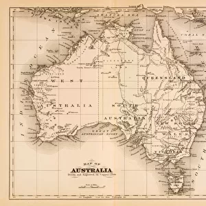
Framed Print : Western Australia map 1885


![]()
Framed Photos from Fine Art Storehouse
Western Australia map 1885
Encyclopedia Britannica 9th Edition New York Charles Scribners and Sons 1885 Vol XXIV
Unleash your creativity and transform your space into a visual masterpiece!
THEPALMER
Media ID 14756600
© This content is subject to copyright
21.5"x17.5" (55x44cm) Premium Frame
Introducing the exquisite "Western Australia Map 1885" framed print from Media Storehouse's Fine Art Storehouse collection. This stunning piece is a reproduction of an original map taken from the Encyclopedia Britannica 9th Edition, published by Charles Scribner's Sons in New York in 1885. The map, titled "Western Australia," is a captivating glimpse into the historical cartography of the region. The intricate details of the map are brought to life in this framed print, making it a beautiful addition to any home or office. The high-quality print is carefully framed in a sleek, modern design, ensuring that it stands out as a conversation starter and a source of intrigue. Travel back in time and explore the history of Western Australia with this stunning framed print.
Framed and mounted 17x12 print. Professionally handmade full timber moulded frames are finished off with framers tape and come with a hanging solution on the back. Outer dimensions are 21.5x17.5 inches (546x444mm). Quality timber frame frame moulding (20mm wide and 30mm deep) with frame colours in your choice of black, white, or raw oak and a choice of black or white card mounts. Frames have a perspex front providing a virtually unbreakable glass-like finish which is easily cleaned with a damp cloth.
Contemporary Framed and Mounted Prints - Professionally Made and Ready to Hang
Estimated Image Size (if not cropped) is 41.8cm x 41.8cm (16.5" x 16.5")
Estimated Product Size is 44.4cm x 54.6cm (17.5" x 21.5")
These are individually made so all sizes are approximate
Artwork printed orientated as per the preview above, with landscape (horizontal) or portrait (vertical) orientation to match the source image.
FEATURES IN THESE COLLECTIONS
> Fine Art Storehouse
> Map
> Historical Maps
> Animals
> Mammals
> Muridae
> Western Mouse
> Maps and Charts
> Related Images
> North America
> United States of America
> New York
> New York
> Maps
> North America
> United States of America
> New York
> Related Images
> Oceania
> Australia
> Related Images
EDITORS COMMENTS
In this print titled "Western Australia map 1885" we are transported back in time to the late 19th century. The image showcases a beautifully detailed map, sourced from the Encyclopedia Britannica's 9th Edition, published by Charles Scribners and Sons in New York in 1885. The map itself is an exquisite representation of Western Australia during that era. Every contour, river, and coastline has been meticulously drawn with precision and care. It serves as both a historical artifact and a work of art, capturing the essence of exploration and discovery prevalent at the time. As we gaze upon this vintage piece, our imagination takes flight. We envision intrepid explorers venturing into uncharted territories, indigenous cultures thriving amidst vast landscapes, and bustling towns emerging along coastal regions. This snapshot from history invites us to delve deeper into Western Australia's rich heritage. "ThePalmer" the talented artist behind this print available through Fine Art Storehouse, has skillfully preserved every intricate detail while infusing it with their own artistic touch. Through their lens or scanner, they have breathed new life into this antique treasure for all to appreciate. Whether you're an avid historian or simply captivated by maps' allure as works of art themselves, "Western Australia map 1885" promises to transport you on a journey through time like no other.
MADE IN AUSTRALIA
Safe Shipping with 30 Day Money Back Guarantee
FREE PERSONALISATION*
We are proud to offer a range of customisation features including Personalised Captions, Color Filters and Picture Zoom Tools
SECURE PAYMENTS
We happily accept a wide range of payment options so you can pay for the things you need in the way that is most convenient for you
* Options may vary by product and licensing agreement. Zoomed Pictures can be adjusted in the Cart.