Framed Print > Arts > Photorealistic artworks > Detailed art pieces > Masterful detailing in art
Framed Print : Michigan Vector Map


![]()
Framed Photos from Fine Art Storehouse
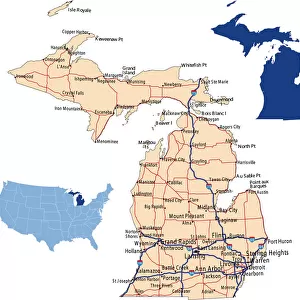
Michigan Vector Map
Highly detailed vector map of Michigan, United States. File was created on November 14, 2012. The colors in the.eps-file are ready for print (CMYK). Included files: EPS (v8) and Hi-Res JPG (5600aa aaa 5600 px)
Unleash your creativity and transform your space into a visual masterpiece!
Media ID 14833441
13.5"x11.5" (34x29cm) Premium Frame
Discover the intricate beauty of Michigan with our Framed Prints from Media Storehouse. Featuring a highly detailed vector map of the Great Lakes State, this unique artwork showcases Michigan's distinct geography in vibrant CMYK colors. Created on November 14, 2012, this fine art piece is not just a map, but a work of art that tells a story. Bring the rich history and culture of Michigan into your home or office with our premium framed prints, expertly crafted to preserve the beauty and detail of this exquisite vector design.
Framed and mounted 9x7 print. Professionally handmade full timber moulded frames are finished off with framers tape and come with a hanging solution on the back. Outer dimensions are 13.5x11.5 inches (34x29cm). Quality timber frame frame moulding (20mm wide and 30mm deep) with frame colours in your choice of black, white, or raw oak and a choice of black or white card mounts. Frames have a perspex front providing a virtually unbreakable glass-like finish which is easily cleaned with a damp cloth.
Contemporary Framed and Mounted Prints - Professionally Made and Ready to Hang
Estimated Image Size (if not cropped) is 21.4cm x 21.4cm (8.4" x 8.4")
Estimated Product Size is 29.2cm x 34cm (11.5" x 13.4")
These are individually made so all sizes are approximate
Artwork printed orientated as per the preview above, with landscape (horizontal) or portrait (vertical) orientation to match the source image.
FEATURES IN THESE COLLECTIONS
> Fine Art Storehouse
> Map
> Map Illustrations
> Arts
> Photorealistic artworks
> Detailed art pieces
> Masterful detailing in art
> Maps and Charts
> Related Images
EDITORS COMMENTS
This stunning print features a highly detailed vector map of Michigan, United States. Created on November 14,2012, this file showcases the state's intricate geographical features with remarkable precision. The colors in the. eps-file are specifically designed for print using CMYK technology, ensuring vibrant and accurate reproduction. The beauty of this artwork lies in its meticulous attention to detail. Every city, town, river, and highway is intricately depicted on this map, making it an invaluable resource for anyone interested in exploring or studying Michigan's geography. Whether you're a resident proud of your home state or a traveler looking to commemorate a memorable trip to the Great Lakes region, this print will undoubtedly captivate your imagination. Included with this purchase are two files: EPS (v8) and Hi-Res JPG (5600 x 5600 px). These formats provide flexibility for various printing needs while maintaining exceptional image quality.
MADE IN AUSTRALIA
Safe Shipping with 30 Day Money Back Guarantee
FREE PERSONALISATION*
We are proud to offer a range of customisation features including Personalised Captions, Color Filters and Picture Zoom Tools
SECURE PAYMENTS
We happily accept a wide range of payment options so you can pay for the things you need in the way that is most convenient for you
* Options may vary by product and licensing agreement. Zoomed Pictures can be adjusted in the Cart.