Framed Print > Africa > Morocco > Maps
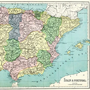
Framed Print : Antique illustration from US navy and army: Spain, Portugal, Morocco and Canary Islands map


![]()
Framed Photos from Fine Art Storehouse
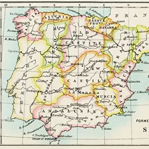
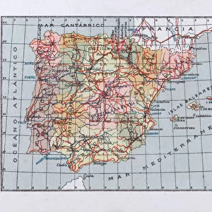
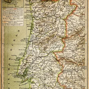
Antique illustration from US navy and army: Spain, Portugal, Morocco and Canary Islands map
Unleash your creativity and transform your space into a visual masterpiece!
ilbusca
Media ID 18298727
13.5"x11.5" (34x29cm) Premium Frame
Step back in time with our exquisite Framed Print featuring an antique illustration of a Spain, Portugal, Morocco, and Canary Islands map from the US Navy and Army archives. This captivating piece, sourced from ilbusca's Fine Art Storehouse collection, beautifully showcases the historical cartography of the Iberian Peninsula, North Africa, and the Canary Islands. Its aged appearance adds a timeless charm to any room, making it a perfect addition to your home or office decor. Embrace history and bring a touch of the past into your space with this stunning framed print.
Framed and mounted 9x7 print. Professionally handmade full timber moulded frames are finished off with framers tape and come with a hanging solution on the back. Outer dimensions are 13.5x11.5 inches (34x29cm). Quality timber frame frame moulding (20mm wide and 30mm deep) with frame colours in your choice of black, white, or raw oak and a choice of black or white card mounts. Frames have a perspex front providing a virtually unbreakable glass-like finish which is easily cleaned with a damp cloth.
Contemporary Framed and Mounted Prints - Professionally Made and Ready to Hang
Estimated Image Size (if not cropped) is 21.4cm x 21.4cm (8.4" x 8.4")
Estimated Product Size is 29.2cm x 34cm (11.5" x 13.4")
These are individually made so all sizes are approximate
Artwork printed orientated as per the preview above, with landscape (horizontal) or portrait (vertical) orientation to match the source image.
FEATURES IN THESE COLLECTIONS
> Fine Art Storehouse
> Map
> Historical Maps
> Fine Art Storehouse
> Travel Imagery
> Travel Destinations
> Morocco, North Africa
> Africa
> Morocco
> Related Images
> Europe
> Portugal
> Related Images
> Europe
> Spain
> Related Images
> Maps and Charts
> Related Images
EDITORS COMMENTS
This print titled "Antique illustration from US navy and army: Spain, Portugal, Morocco and Canary Islands map" takes us on a historical journey through the intricate cartography of yesteryears. With its rich details and exquisite craftsmanship, this piece showcases the expertise of the artists who meticulously crafted maps for the United States Navy and Army. The map itself encompasses an expansive region, spanning across Spain, Portugal, Morocco, and the Canary Islands. Its vintage charm transports us to a time when exploration was at its peak and these lands held great allure for adventurers seeking new horizons. Every line drawn on this antique illustration tells a story of discovery and conquest. It serves as a testament to human curiosity and ambition that drove explorers to brave uncharted territories in search of knowledge and riches. As we gaze upon this remarkable artwork by ilbusca from Fine Art Storehouse, we are reminded of how far we have come in our understanding of geography while appreciating the artistry behind these early navigational tools. This print is not just an aesthetic delight but also a window into history—an invitation to explore our past with fresh eyes. Whether displayed in homes or offices, this print will undoubtedly spark conversations about exploration's golden age while adding a touch of elegance to any space.
MADE IN AUSTRALIA
Safe Shipping with 30 Day Money Back Guarantee
FREE PERSONALISATION*
We are proud to offer a range of customisation features including Personalised Captions, Color Filters and Picture Zoom Tools
FREE COLORIZATION SERVICE
You can choose advanced AI Colorization for this picture at no extra charge!
SECURE PAYMENTS
We happily accept a wide range of payment options so you can pay for the things you need in the way that is most convenient for you
* Options may vary by product and licensing agreement. Zoomed Pictures can be adjusted in the Cart.