Framed Print > Arts > Landscape paintings > Waterfall and river artworks > River artworks
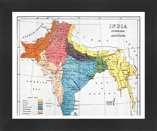
Framed Print : INDIA: MAP, 19th CENTURY. Map of India depicting the seven ethnological classifications developed by Sir Herbert Hope


![]()
Framed Photos from Granger
INDIA: MAP, 19th CENTURY. Map of India depicting the seven ethnological classifications developed by Sir Herbert Hope
INDIA: MAP, 19th CENTURY. Map of India depicting the seven ethnological classifications developed by Sir Herbert Hope Risley (1851-1911)
Granger holds millions of images spanning more than 25,000 years of world history, from before the Stone Age to the dawn of the Space Age
Media ID 6622349
Asian British Empire British Raj Colonialism Colony Herbert Hope India Ethnology
13.5"x11.5" (34x29cm) Premium Frame
Discover the rich history and diversity of India with our stunning Framed Print of the 19th Century Map of India from The Granger Collection. This captivating map, created by Sir Herbert Hope Risley, showcases India's ethnographic divisions during that era, offering a unique insight into the cultural classifications of the time. Add this exquisite piece to your decor and transport yourself on a journey through history. Order now from Media Storehouse's Art on Demand and bring a piece of the past into your home or office.
Framed and mounted 9x7 print. Professionally handmade full timber moulded frames are finished off with framers tape and come with a hanging solution on the back. Outer dimensions are 13.5x11.5 inches (34x29cm). Quality timber frame frame moulding (20mm wide and 30mm deep) with frame colours in your choice of black, white, or raw oak and a choice of black or white card mounts. Frames have a perspex front providing a virtually unbreakable glass-like finish which is easily cleaned with a damp cloth.
Contemporary Framed and Mounted Prints - Professionally Made and Ready to Hang
Estimated Image Size (if not cropped) is 21.4cm x 21.4cm (8.4" x 8.4")
Estimated Product Size is 34cm x 29.2cm (13.4" x 11.5")
These are individually made so all sizes are approximate
Artwork printed orientated as per the preview above, with landscape (horizontal) or portrait (vertical) orientation to match the source image.
FEATURES IN THESE COLLECTIONS
> Arts
> Landscape paintings
> Waterfall and river artworks
> River artworks
> Asia
> India
> Related Images
> Asia
> Related Images
> Maps and Charts
> British Empire Maps
> Maps and Charts
> India
> Maps and Charts
> Related Images
> Granger Art on Demand
> Maps
EDITORS COMMENTS
INDIA: MAP, 19th CENTURY. A fascinating glimpse into India's diverse tapestry of cultures and identities is captured in this vintage map print. Created by Sir Herbert Hope Risley, a prominent ethnologist of the time, it showcases his pioneering work in classifying the Indian population into seven distinct categories. As colonialism swept across the subcontinent, this map serves as a reminder of the British Empire's influence on India during the 19th century. The English presence is evident not only through their territorial control but also in their efforts to understand and categorize the indigenous people. The intricate details of rivers and geographical features provide a visual backdrop to Risley's ethnological classifications. This map becomes an invaluable resource for historians and scholars studying India's complex social fabric during that era. Beyond its historical significance, this print invites us to reflect on how colonial rule shaped India's identity and cultural landscape. It prompts us to question notions of power dynamics between colonizers and colonized while acknowledging the resilience and diversity that define Indian society even today. Displayed proudly on any wall or study space, this Granger Collection artwork sparks conversations about imperialism, ethnicity, and national identity. It stands as a testament to both Sir Herbert Hope Risley's groundbreaking research as well as India's enduring spirit.
MADE IN AUSTRALIA
Safe Shipping with 30 Day Money Back Guarantee
FREE PERSONALISATION*
We are proud to offer a range of customisation features including Personalised Captions, Color Filters and Picture Zoom Tools
SECURE PAYMENTS
We happily accept a wide range of payment options so you can pay for the things you need in the way that is most convenient for you
* Options may vary by product and licensing agreement. Zoomed Pictures can be adjusted in the Cart.