Framed Print > Arts > Artists > M > Juan Martinez
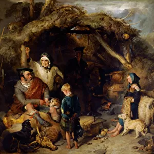
Framed Print : MAP: AMERICA, 1582. Map of South America by Juan Martinez, 1582


![]()
Framed Photos from Granger
MAP: AMERICA, 1582. Map of South America by Juan Martinez, 1582
MAP: AMERICA, 1582.
Map of South America by Juan Martinez, 1582
Granger holds millions of images spanning more than 25,000 years of world history, from before the Stone Age to the dawn of the Space Age
Media ID 12321390
1582 Chart Colonial Juan Martinez South America Spanish Symbol
A2 Premium Frame with A3 Poster
Discover the rich history of cartography with our exquisite Framed Prints from Granger, NYC's The Granger Collection. This captivating piece showcases a rare map of South America, originally created by Juan Martinez in 1582. The intricate details of this map transport you back in time, providing a unique glimpse into the early exploration of the New World. Our Framed Prints are meticulously crafted, ensuring the highest quality and authenticity. Add this beautiful and historically significant artwork to your home or office, and let the story of America's past unfold before your eyes.
Premium Paradise Wooden Range A2 Premium Poster Frame (62x45cm) with A3 Poster (42x30cm) and mounted behind a white matt board to make your photo really stand out. FSC Certified and Rainforest Alliance Certified for environmental, social, and economic sustainably. High transparency tempered glass window with a smooth finished frame. Great for filling empty walls, decorating blank spaces, or creating eye-catching gallery walls. Frames arrive ready to hang. Sent with secure, protective packaging. Smooth wooden veneer mimics the real wood look and feel with ultra-durable scratch resistance tempered glass.
Contemporary Framed and Mounted Prints - Professionally Made and Ready to Hang
Estimated Image Size (if not cropped) is 40.4cm x 40.4cm (15.9" x 15.9")
Estimated Product Size is 62cm x 44.6cm (24.4" x 17.6")
These are individually made so all sizes are approximate
Artwork printed orientated as per the preview above, with landscape (horizontal) or portrait (vertical) orientation to match the source image.
FEATURES IN THESE COLLECTIONS
> Arts
> Artists
> M
> Juan Martinez
> Historic
> Colonial America illustrations
> Colonial America
> Maps and Charts
> Related Images
> Maps and Charts
> Spain
> South America
> Related Images
> Granger Art on Demand
> Maps
EDITORS COMMENTS
This print showcases a remarkable piece of history, the "MAP: AMERICA, 1582". Created by Juan Martinez in the late 16th century, this map offers a fascinating glimpse into South America during colonial times. With intricate details and exquisite craftsmanship, Martinez's map takes us on a journey through time. Every stroke of his pen tells a story of exploration and conquest as Spanish influence spreads across the continent. The map serves as both an educational tool and a symbol of cultural exchange between Europe and the New World. As we study this ancient cartographic gem, we are transported to an era where boundaries were being redrawn and new frontiers discovered. The names of cities long forgotten come alive once more, reminding us of their significance in shaping our modern world. The Granger Collection has beautifully captured this historical artifact with stunning clarity and precision. Through their lens, every line becomes more pronounced; every text reveals its hidden meaning. This print allows us to appreciate not only the artistry behind Martinez's work but also its historical importance. Whether you are an avid historian or simply intrigued by the wonders of our past, this print is sure to captivate your imagination. It serves as a testament to human curiosity and reminds us that even centuries later, these maps continue to hold immense value in understanding our shared heritage.
MADE IN AUSTRALIA
Safe Shipping with 30 Day Money Back Guarantee
FREE PERSONALISATION*
We are proud to offer a range of customisation features including Personalised Captions, Color Filters and Picture Zoom Tools
SECURE PAYMENTS
We happily accept a wide range of payment options so you can pay for the things you need in the way that is most convenient for you
* Options may vary by product and licensing agreement. Zoomed Pictures can be adjusted in the Cart.