Framed Print > North America > United States of America > New York > New York > Sights > Wall Street
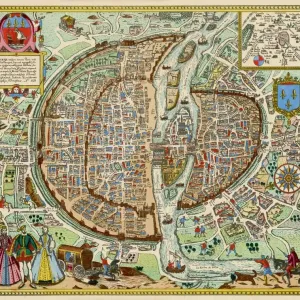
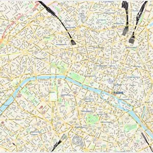
Framed Print : PARIS MAP, 1581. Map of Paris, France, by Georg Braun from Civitates Orbis Terarum, 1581


![]()
Framed Photos from Granger
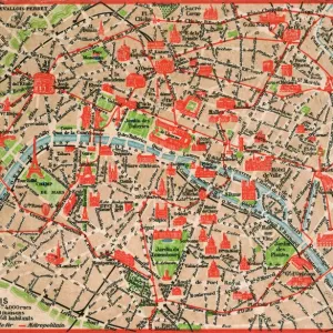
PARIS MAP, 1581. Map of Paris, France, by Georg Braun from Civitates Orbis Terarum, 1581
PARIS MAP, 1581.
Map of Paris, France, by Georg Braun from Civitates Orbis Terarum, 1581
Granger holds millions of images spanning more than 25,000 years of world history, from before the Stone Age to the dawn of the Space Age
Media ID 6263237
1581 Braun Civitates Orbis Terrarum Georg Moat Seine Wall
A2 Premium Frame with A3 Poster
Step back in time with our exquisite Framed Prints featuring the 1581 Map of Paris by Georg Braun from Civitates Orbis Terarum. This vintage map transports you to the streets of Paris during the Renaissance era. The intricate details of the city's architecture and geography are brought to life in this beautifully preserved piece of history. Display this unique and captivating work of art in your home or office to add an air of sophistication and historical charm.
Premium Paradise Wooden Range A2 Premium Poster Frame (62x45cm) with A3 Poster (42x30cm) and mounted behind a white matt board to make your photo really stand out. FSC Certified and Rainforest Alliance Certified for environmental, social, and economic sustainably. High transparency tempered glass window with a smooth finished frame. Great for filling empty walls, decorating blank spaces, or creating eye-catching gallery walls. Frames arrive ready to hang. Sent with secure, protective packaging. Smooth wooden veneer mimics the real wood look and feel with ultra-durable scratch resistance tempered glass.
Contemporary Framed and Mounted Prints - Professionally Made and Ready to Hang
Estimated Image Size (if not cropped) is 40.4cm x 40.4cm (15.9" x 15.9")
Estimated Product Size is 62cm x 44.6cm (24.4" x 17.6")
These are individually made so all sizes are approximate
Artwork printed orientated as per the preview above, with landscape (horizontal) or portrait (vertical) orientation to match the source image.
FEATURES IN THESE COLLECTIONS
> Europe
> France
> Paris
> Maps
> Europe
> France
> Paris
> River Seine
> Maps and Charts
> Related Images
> North America
> United States of America
> New York
> New York
> Sights
> Wall Street
> Granger Art on Demand
> Maps
EDITORS COMMENTS
This print showcases a remarkable piece of history - the "PARIS MAP, 1581". Created by Georg Braun for Civitates Orbis Terarum in the late 16th century, this map offers a fascinating glimpse into the city of Paris during that era. The intricately detailed engraving depicts the bustling streets and winding alleys of Paris, with its iconic River Seine flowing gracefully through its heart. The map also highlights significant landmarks such as walls, moats, and even a carousel collection - providing an invaluable snapshot of French culture at the time. As we observe this historical artifact closely, we can't help but be drawn to the people depicted within it. A woman and man caught in conversation near one corner remind us that life has always thrived on these very streets. Their presence adds depth to our understanding of how society functioned centuries ago. This print from Granger Art on Demand allows us to appreciate not only the artistry involved in creating such a detailed map but also serves as a reminder of how cities evolve over time. It is an excellent addition for any history enthusiast or lover of all things Parisian who wishes to immerse themselves in France's rich past.
MADE IN AUSTRALIA
Safe Shipping with 30 Day Money Back Guarantee
FREE PERSONALISATION*
We are proud to offer a range of customisation features including Personalised Captions, Color Filters and Picture Zoom Tools
SECURE PAYMENTS
We happily accept a wide range of payment options so you can pay for the things you need in the way that is most convenient for you
* Options may vary by product and licensing agreement. Zoomed Pictures can be adjusted in the Cart.