Framed Print > Arts > Artists > C > William Caxton
Framed Print : Map To Illustrate The Campaign in Palestine, 1919. Creator: London Geographical Institute


![]()
Framed Photos from Heritage Images
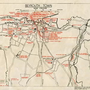
Map To Illustrate The Campaign in Palestine, 1919. Creator: London Geographical Institute
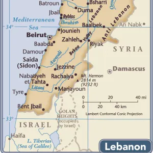
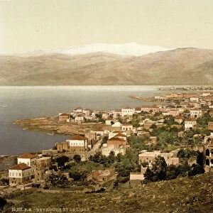
Map To Illustrate The Campaign in Palestine, 1919. Map of the Eastern Mediterrean and the Middle East, showing Cyprus, Port Said in Egypt, parts of Turkey and what are now Syria, the Lebanon, Israel and the Occupied Territories including Gaza. From " The History of the Great European War: its causes and effects", Vol. IX, by W. Stanley Macbean Knight. [Caxton Pulishing Company, Limited, London, 1919]
Heritage Images features heritage image collections
Media ID 19047561
© The Print Collector/Heritage Images
Beirut Bur Said Campaign Caxton Publishing Company Caxton Pulishing Company Caxton Pulishing Company Lim Caxton Pulishing Company Limited Caxton Pulishing Company Ltd Cyprus Israel Knight Lebanon Limited London Geographical Institute Mediterranean Palestine Port Said Stanley Macbean Stanley Macbean Knight Syria Turkey W Stanley Macbean W Stanley Macbean Knight William Stanley Macbean William Stanley Macbean Knight Gaza
A2 Premium Frame with A3 Poster
Step back in time with our vintage Framed Print from Media Storehouse, featuring the "Map To Illustrate The Campaign in Palestine, 1919" from Heritage Images. This intricately detailed map, created by the London Geographical Institute, offers a captivating glimpse into history. The map illustrates the Eastern Mediterranean and the Middle East, highlighting key locations such as Cyprus, Port Said in Egypt, and parts of Syria and the Lebanon. A must-have for history enthusiasts and collectors, this framed print adds an air of elegance and sophistication to any room while showcasing an important piece of historical cartography.
Premium Paradise Wooden Range A2 Premium Poster Frame (62x45cm) with A3 Poster (42x30cm) and mounted behind a white matt board to make your photo really stand out. FSC Certified and Rainforest Alliance Certified for environmental, social, and economic sustainably. High transparency tempered glass window with a smooth finished frame. Great for filling empty walls, decorating blank spaces, or creating eye-catching gallery walls. Frames arrive ready to hang. Sent with secure, protective packaging. Smooth wooden veneer mimics the real wood look and feel with ultra-durable scratch resistance tempered glass.
Contemporary Framed and Mounted Prints - Professionally Made and Ready to Hang
Estimated Image Size (if not cropped) is 40.4cm x 40.4cm (15.9" x 15.9")
Estimated Product Size is 44.6cm x 62cm (17.6" x 24.4")
These are individually made so all sizes are approximate
Artwork printed orientated as per the preview above, with landscape (horizontal) or portrait (vertical) orientation to match the source image.
FEATURES IN THESE COLLECTIONS
> Africa
> Egypt
> Related Images
> Arts
> Artists
> C
> William Caxton
> Arts
> Artists
> S
> Syrian Syrian
> Asia
> Cyprus
> Related Images
> Asia
> Israel
> Related Images
EDITORS COMMENTS
This print showcases a historic map titled "Map To Illustrate The Campaign in Palestine, 1919". Created by the esteemed London Geographical Institute, this detailed map takes us back to the early 20th century during World War I. It depicts the Eastern Mediterranean and Middle East regions, featuring significant locations such as Cyprus, Port Said in Egypt, parts of Turkey, Syria, Lebanon, Israel, and the Occupied Territories including Gaza. Originally published in "The History of the Great European War: its causes and effects". Volume IX by W. Stanley Macbean Knight in 1919 under Caxton Publishing Company Limited in London. This remarkable piece offers valuable insights into the geographical features and strategic importance of these areas during that time. With vibrant colors highlighting coastlines and urban centers like Beirut in Lebanon and Bur Said in Egypt along with sea routes connecting various territories across the Mediterranean Sea, this map serves as a visual representation of an era marked by conflict and transformation. As we delve into this historical artifact captured by The Print Collector from Heritage Images collection, we are transported to a pivotal moment where world powers were vying for control over these lands amidst the chaos of war. It stands as a testament to human endeavors to understand our surroundings while shedding light on how past events have shaped our present reality.
MADE IN AUSTRALIA
Safe Shipping with 30 Day Money Back Guarantee
FREE PERSONALISATION*
We are proud to offer a range of customisation features including Personalised Captions, Color Filters and Picture Zoom Tools
SECURE PAYMENTS
We happily accept a wide range of payment options so you can pay for the things you need in the way that is most convenient for you
* Options may vary by product and licensing agreement. Zoomed Pictures can be adjusted in the Cart.