


Framed Prints From Heritage Images
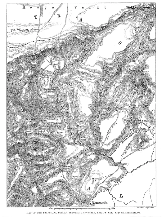
Framed Print of Map of the Transvaal border between Newcastle, Laing's Nek and Wakkerstroom, 1881
Map of the Transvaal border between Newcastle, Laing's Nek and Wakkerstroom, 1881. A portion of the rugged highlands on the borders of Natal and the Transvaal country, where the British forces under Sir George Colley and Sir Evelyn Wood have to encounter the opposing Boers, under Commandant Franz Joubert, in the renewed advance this week, is delineated in our Map. The starting-point of their advance is the town of Newcastle, in Natal, the British headquarters for this campaign; and the immediate object is to force a passage to the Hooge Veldt or high open plain of the Transvaal, a sort of table-land, which is indicated at the top of the Map. The situation of Newcastle, about thirty miles distant in a straight line, as the crow flies, is seen at the bottom...On the 8th Feb. Colley was attacked on both flanks, and in his front, by...combined parties of the Boers, while on his road to reopen the communications between his camp and Newcastle. This conflict took place on the elongated hill, clearly shown... one extremity of which is called Schain's Hooghte, and which extends between the Imbazane and Ingogo rivers...over the hills to Wakkerstroom...is the second or alternative route to get up to the Hooge Veldt or elevated open plain'. From "Illustrated London News", 1881. Heritage Images features heritage image collections. © The Print Collector/Heritage Images
Artwork supplied by Heritage Images
Your chosen combination is quickly and professionally made to order, our shipping page has more details
If you are not entirely happy with your items, simply return them to us within 30 days for a replacement or full refund. Please read our full returns policy.
Media ID 47268030
Illustrated London News Prints , Wood Engraving Art History
Editors Comments
a piece of history from our range. This framed print, "Map of the Transvaal border between Newcastle, Laing's Nek and Wakkerstroom, 1881" by Stanford's Geographical Establishment from Heritage Images, is a representation of the past. Bring a touch of nostalgia and sophistication to any room with this piece that shows the rich heritage of South Africa's history.
This artwork is also available as...
Photo Prints - Discover the beauty of Photo Prints featuring 'Map of the Transvaal border between Newcastle, Laing's Nek and Wakkerstroom, 1881' by Stanford's Geographical Establishment from Heritage Images. Our Photo Prints are perfect for home decor, office spaces or as a gift. Order now and bring historical maps to life with our premium prints.
Greetings Cards - Greetings Cards featuring historical maps, such as the Map of the Transvaal border between Newcastle, Laing's Nek and Wakkerstroom, 1881 by Stanford's Geographical Establishment from Heritage Images. Perfect for history buffs and those looking for thoughtful gifts, our Greetings Cards combine nostalgia with personal touch. Ideal for birthdays, anniversaries or get well wishes.
Photo Mugs - Personalize your home with Photo Mugs featuring historical maps like the Map of the Transvaal border between Newcastle, Laing's Nek and Wakkerstroom, 1881 from Stanford's Geographical Establishment. Perfect for history enthusiasts and map lovers, our Photo Mugs make thoughtful gifts or decorations for any room in your house.
Poster Prints - Discover the rich history of South Africa with our Poster Prints featuring 'Map of the Transvaal border between Newcastle, Laing's Nek and Wakkerstroom, 1881' by Stanford's Geographical Establishment from Heritage Images. Perfect for home decor or office space, our vintage map prints are an addition to any room.
Metal Prints - Metal Prints, a modern and durable way to showcase images like the vintage Map of the Transvaal border between Newcastle, Laing's Nek and Wakkerstroom, 1881 from Stanford's Geographical Establishment. Perfect for art lovers and history enthusiasts alike, Metal Prints offer colors and long-lasting quality.
Canvas Prints - Bring history to life with our Canvas Prints, featuring vintage maps like the 1881 Map of the Transvaal border between Newcastle, Laing's Nek and Wakkerstroom from Stanford's Geographical Establishment. Perfect for home decor or office spaces, our Canvas Prints are durable and long-lasting art pieces ideal for interior design enthusiasts.
Cushions - Cushions featuring vintage maps, such as the 1881 Map of the Transvaal border between Newcastle, Laing's Nek and Wakkerstroom from Stanford's Geographical Establishment. Perfect for history buffs and travel enthusiasts, these decorative Cushions add a touch of nostalgia to any room while showcasing fascinating geographical designs.
Mouse Mats - Mouse Mats featuring historical maps, such as the Map of the Transvaal border between Newcastle, Laing's Nek and Wakkerstroom, 1881 from Stanford's Geographical Establishment. Perfect for history buffs and office decor enthusiasts, these educational Mouse Mats combine functionality with fascinating geography and design elements.
Premium Frame A1 (A2 Poster)
Ready to Hang Contemporary Framed Prints adds style, protection, and a polished touch to your space - effortlessly.
Your artwork will be printed as shown in the preview. To adjust please select Edit Printed Image under the Buy button
Premium Paradise Wooden Range A1 Premium Poster Frame (86x62cm) with A2 Poster (59x42cm) and mounted behind a white matt board to make your photo really stand out. FSC Certified and Rainforest Alliance Certified for environmental, social, and economic sustainably. High transparency tempered glass window with a smooth finished frame. Great for filling empty walls, decorating blank spaces, or creating eye-catching gallery walls. Frames arrive ready to hang. Sent with secure, protective packaging. Smooth wooden veneer mimics the real wood look and feel with ultra-durable scratch resistance tempered glass. Note: measurements provided are estimated outer dimensions, which include both the image and the frame. While we aim to keep sizing consistent, exact dimensions may vary slightly due to differences in print size or production requirements, which may result in a variation in the overall size (up to approximately 2.5cm (1"))
These are individually made so all sizes are approximate
Estimated Image Size (if not cropped) is 41.4cm x 58.8cm (16.3" x 23.1")
Estimated Product Size is 62cm x 86.6cm (24.4" x 34.1")
Features In These Collections
> Africa > South Africa > Maps