Framed Print > Europe > France > Maps
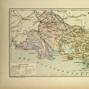
Framed Print : Map of Arles and Cette, France


![]()
Framed Photos from Liszt Collection
Map of Arles and Cette, France
Liszt Collection of nineteenth-century engravings and images to browse and enjoy
Media ID 12974979
© Quint Lox Limited
A2 Premium Frame with A3 Poster
Discover the timeless beauty of France with our exquisite Framed Print of "Map of Arles and Cette, France" from the Liszt Collection. This stunning piece, featuring the intricate and detailed map of the regions of Arles and Cette, is a must-have for any space that seeks to evoke the essence of French history and culture. The high-quality print is expertly framed, ensuring a polished and sophisticated look that will add character to your home or office. Travel in time and place with this beautiful and captivating Framed Print from Media Storehouse.
Premium Paradise Wooden Range A2 Premium Poster Frame (62x45cm) with A3 Poster (42x30cm) and mounted behind a white matt board to make your photo really stand out. FSC Certified and Rainforest Alliance Certified for environmental, social, and economic sustainably. High transparency tempered glass window with a smooth finished frame. Great for filling empty walls, decorating blank spaces, or creating eye-catching gallery walls. Frames arrive ready to hang. Sent with secure, protective packaging. Smooth wooden veneer mimics the real wood look and feel with ultra-durable scratch resistance tempered glass.
Contemporary Framed and Mounted Prints - Professionally Made and Ready to Hang
Estimated Image Size (if not cropped) is 40.4cm x 40.4cm (15.9" x 15.9")
Estimated Product Size is 62cm x 44.6cm (24.4" x 17.6")
These are individually made so all sizes are approximate
Artwork printed orientated as per the preview above, with landscape (horizontal) or portrait (vertical) orientation to match the source image.
FEATURES IN THESE COLLECTIONS
> Maps and Charts
> Related Images
> Liszt Collection
> Engravings
> France
EDITORS COMMENTS
This vintage print titled "Map of Arles and Cette, France" takes us on a journey back in time to the enchanting nineteenth century. The intricate engravement technique used to create this piece showcases the remarkable illustrative skills of that era. With its retro-styled appeal, it effortlessly transports us to a bygone era filled with rich history and cultural significance. The map itself is a fascinating depiction of two iconic French cities - Arles and Cette. Every detail has been meticulously etched onto the paper, allowing us to explore these towns as they were centuries ago. From the winding streets and charming architecture to the bustling ports and majestic landmarks, this map offers an immersive experience into the past. As we gaze upon this artwork, we can't help but appreciate how it encapsulates both artistry and historical documentation. Its Victorian aesthetic adds an extra layer of charm, making it a perfect addition for any lover of arts or culture. Whether you're an avid collector or simply someone who appreciates nostalgia, this print from Liszt Collection captures the essence of a forgotten time in French history. It serves as a reminder that even in our fast-paced modern world, there's always room for reflection on our roots and appreciation for traditional craftsmanship.
MADE IN AUSTRALIA
Safe Shipping with 30 Day Money Back Guarantee
FREE PERSONALISATION*
We are proud to offer a range of customisation features including Personalised Captions, Color Filters and Picture Zoom Tools
SECURE PAYMENTS
We happily accept a wide range of payment options so you can pay for the things you need in the way that is most convenient for you
* Options may vary by product and licensing agreement. Zoomed Pictures can be adjusted in the Cart.