Framed Print > Europe > United Kingdom > Scotland > Highlands > Wick
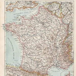
Framed Print : Map La carte nouvelle de la France ses conquetes


![]()
Framed Photos From Liszt Collection
Map La carte nouvelle de la France ses conquetes
Map, La carte nouvelle de la France, ses conquetes, ses acquisitions, et ses bornes. Par la paix de Ris-wick =, Nicolas de Fer (1646-1720), Copperplate print
Liszt Collection of nineteenth-century engravings and images to browse and enjoy
Media ID 19586277
© Artokoloro
13.5"x11.5" (34x29cm) Premium Frame
Discover the rich history of France with our stunning Framed Print from the Media Storehouse Liszt Collection. This exquisite Copperplate print, titled "Map La carte nouvelle de la France, ses conquetes, ses acquisitions, et ses bornes," showcases the expansive territories and significant acquisitions of France during the Peace of Ryswick. Created by renowned cartographer Nicolas de Fer in 1693, this intricately detailed map is a captivating piece of historical art. Elevate your home or office decor with this beautiful, framed print and transport yourself back in time to an era of exploration and conquest.
Framed and mounted 9x7 print. Professionally handmade full timber moulded frames are finished off with framers tape and come with a hanging solution on the back. Outer dimensions are 13.5x11.5 inches (34x29cm). Quality timber frame frame moulding (20mm wide and 30mm deep) with frame colours in your choice of black, white, or raw oak and a choice of black or white card mounts. Frames have a perspex front providing a virtually unbreakable glass-like finish which is easily cleaned with a damp cloth.
Contemporary Framed and Mounted Prints - Professionally Made and Ready to Hang
Estimated Image Size (if not cropped) is 21.4cm x 21.4cm (8.4" x 8.4")
Estimated Product Size is 34cm x 29.2cm (13.4" x 11.5")
These are individually made so all sizes are approximate
Artwork printed orientated as per the preview above, with landscape (horizontal) or portrait (vertical) orientation to match the source image.
FEATURES IN THESE COLLECTIONS
> Arts
> Artists
> D
> Nicolas de Fer
> Europe
> United Kingdom
> Scotland
> Highlands
> Wick
> Maps and Charts
> Related Images
EDITORS COMMENTS
This print showcases the historical map titled "La carte nouvelle de la France, ses conquêtes, ses acquisitions, et ses bornes. Par la paix de Ris-wick" by Nicolas de Fer. Created during the years 1646-1720 using copperplate print technique, this exquisite piece of art offers a glimpse into the cartographic mastery of its creator. The map depicts France and its territorial expansions with intricate detail and precision. It highlights the conquests, acquisitions, and boundaries of France as determined by the Peace Treaty of Ryswick. The viewer is transported back in time to an era where cartography played a crucial role in shaping political landscapes. Nicolas de Fer's expertise shines through in this remarkable work as he skillfully captures every geographical feature and boundary line with meticulous accuracy. The rich colors used in this copperplate print add depth and vibrancy to each region depicted on the map. As we admire this print from Liszt Collection, we are reminded of how maps have not only served practical purposes but also acted as visual representations of power dynamics throughout history. This particular artwork serves as a testament to both De Fer's talent as a cartographer and his contribution to documenting France's ever-changing borders during that period
MADE IN AUSTRALIA
Safe Shipping with 30 Day Money Back Guarantee
FREE PERSONALISATION*
We are proud to offer a range of customisation features including Personalised Captions, Color Filters and Picture Zoom Tools
SECURE PAYMENTS
We happily accept a wide range of payment options so you can pay for the things you need in the way that is most convenient for you
* Options may vary by product and licensing agreement. Zoomed Pictures can be adjusted in the Basket.