Framed Print > Arts > Photorealistic artworks > Detailed art pieces > Masterful detailing in art
Framed Print : Old Map of Africa 1852 by Henry George Collins


![]()
Framed Photos from MapSeeker
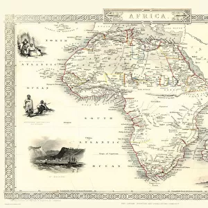
Old Map of Africa 1852 by Henry George Collins
This is a finely detailed map of Africa remastered from a rare Atlas of the World published in 1852 by Henry George Collins. Although these Henry Collins produced maps of the highest quality in his time unfortunately not the same could be said in terms of his business success. His maps were later obtained by the famous Stanford Map Company and used in their publications
Welcome to the Mapseeker Image library and enter an historic gateway to one of the largest on-line collections of Historic Maps, Nostalgic Views, Vista's and Panorama's from a World gone by.
Media ID 20347080
© Mapseeker Publishing Ltd
Collins Collins Atlas Collins Map Continental Map Old Continental Map
A2 Premium Frame with A3 Poster
Discover the rich history of Africa with our exquisite Framed Print of the Old Map of Africa 1852 by Henry George Collins. Meticulously remastered from the rare Atlas of the World published by Henry George Collins, this stunning print showcases intricate details and accurate representations of African geography during that era. Bring a piece of historical cartography into your home or office and transport yourself back in time with every intricately drawn line and vibrant color. A perfect addition to any space, this Framed Print makes for an impressive conversation starter and a cherished collector's item.
Premium Paradise Wooden Range A2 Premium Poster Frame (62x45cm) with A3 Poster (42x30cm) and mounted behind a white matt board to make your photo really stand out. FSC Certified and Rainforest Alliance Certified for environmental, social, and economic sustainably. High transparency tempered glass window with a smooth finished frame. Great for filling empty walls, decorating blank spaces, or creating eye-catching gallery walls. Frames arrive ready to hang. Sent with secure, protective packaging. Smooth wooden veneer mimics the real wood look and feel with ultra-durable scratch resistance tempered glass.
Contemporary Framed and Mounted Prints - Professionally Made and Ready to Hang
Estimated Image Size (if not cropped) is 40.4cm x 40.4cm (15.9" x 15.9")
Estimated Product Size is 62cm x 44.6cm (24.4" x 17.6")
These are individually made so all sizes are approximate
Artwork printed orientated as per the preview above, with landscape (horizontal) or portrait (vertical) orientation to match the source image.
FEATURES IN THESE COLLECTIONS
> Arts
> Photorealistic artworks
> Detailed art pieces
> Masterful detailing in art
> Maps and Charts
> Related Images
> Maps and Charts
> World
> MapSeeker
> Maps of Africa and Oceana
> Old Maps Showing the Continent of
EDITORS COMMENTS
This beautifully preserved print showcases an exquisite piece of cartographic history - the "Old Map of Africa 1852" by Henry George Collins. Remastered from a rare Atlas of the World published in 1852, this map offers a glimpse into the intricate details and craftsmanship that defined Collins' work during his time. Although Henry Collins was renowned for producing maps of unparalleled quality, his business ventures unfortunately did not meet with the same success. However, fate had other plans for these remarkable maps as they were later acquired by none other than the prestigious Stanford Map Company. Recognizing their value and significance, these maps found new life within the pages of their esteemed publications. As we explore this old African map, we are transported back to a time when our understanding of this vast continent was still evolving. Every contour line and geographic feature meticulously depicted on this vintage treasure tells a story of exploration and discovery. From its northern deserts to its southern savannahs, every corner of Africa is brought to life through Collins' artistry. This old continental map serves as a testament to both his skill as a cartographer and our enduring fascination with Africa's rich tapestry of cultures and landscapes. Whether you are an avid historian or simply captivated by the beauty of antique maps, this print is sure to ignite your imagination and transport you on an extraordinary journey through time.
MADE IN AUSTRALIA
Safe Shipping with 30 Day Money Back Guarantee
FREE PERSONALISATION*
We are proud to offer a range of customisation features including Personalised Captions, Color Filters and Picture Zoom Tools
SECURE PAYMENTS
We happily accept a wide range of payment options so you can pay for the things you need in the way that is most convenient for you
* Options may vary by product and licensing agreement. Zoomed Pictures can be adjusted in the Cart.