Framed Print > Maps and Charts > Related Images
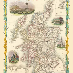
Framed Print : Old Map of the Western Isles from the Philips Handy Atlas of 1882


![]()
Framed Photos from MapSeeker
Old Map of the Western Isles from the Philips Handy Atlas of 1882
PHA031
Welcome to the Mapseeker Image library and enter an historic gateway to one of the largest on-line collections of Historic Maps, Nostalgic Views, Vista's and Panorama's from a World gone by.
Media ID 20348181
13.5"x11.5" (34x29cm) Premium Frame
Step back in time with our captivating Framed Print from Media Storehouse, featuring an Old Map of the Western Isles taken from the Philips Handy Atlas of 1882. This vintage map, sourced from MapSeeker, adds an air of history and charm to any room. The intricate details of the map are beautifully preserved in this high-quality print, which comes already framed and ready to hang. Transport yourself back to a bygone era with this unique and intriguing addition to your decor.
Framed and mounted 9x7 print. Professionally handmade full timber moulded frames are finished off with framers tape and come with a hanging solution on the back. Outer dimensions are 13.5x11.5 inches (34x29cm). Quality timber frame frame moulding (20mm wide and 30mm deep) with frame colours in your choice of black, white, or raw oak and a choice of black or white card mounts. Frames have a perspex front providing a virtually unbreakable glass-like finish which is easily cleaned with a damp cloth.
Contemporary Framed and Mounted Prints - Professionally Made and Ready to Hang
Estimated Image Size (if not cropped) is 21.4cm x 21.4cm (8.4" x 8.4")
Estimated Product Size is 29.2cm x 34cm (11.5" x 13.4")
These are individually made so all sizes are approximate
Artwork printed orientated as per the preview above, with landscape (horizontal) or portrait (vertical) orientation to match the source image.
FEATURES IN THESE COLLECTIONS
> Europe
> United Kingdom
> Scotland
> Western Isles
> Related Images
> Maps and Charts
> Related Images
> MapSeeker
> Maps from the British Isles
> Scotland and Counties PORTFOLIO
EDITORS COMMENTS
This print showcases an exquisite piece of cartographic history, the "Old Map of the Western Isles from the Philips Handy Atlas of 1882". Steeped in nostalgia and intricate details, this vintage map takes us on a journey back to a bygone era. The Western Isles, also known as the Outer Hebrides, are beautifully depicted with remarkable precision and artistry. Every contour line and coastal feature is meticulously etched onto this time-worn parchment. The delicate shading brings to life the rugged landscapes, while tiny symbols denote towns, villages, and landmarks scattered across these remote Scottish islands. As we gaze upon this ancient treasure trove of geographical knowledge, it transports us to a world where exploration was still unfolding. It evokes images of intrepid sailors navigating treacherous waters in search of new lands or merchants plotting their trade routes amidst turbulent seas. Beyond its historical significance lies an aesthetic appeal that captivates our senses. The sepia tones lend an air of antiquity to this mesmerizing artwork; each crease and faded ink stroke tells a tale untold. This photograph preserves not only the map itself but also the essence of adventure encapsulated within its borders. Whether you are an avid collector or simply appreciate glimpses into our past, this print offers a window into forgotten times—a tangible connection between generations separated by centuries yet united through curiosity and discovery.
MADE IN AUSTRALIA
Safe Shipping with 30 Day Money Back Guarantee
FREE PERSONALISATION*
We are proud to offer a range of customisation features including Personalised Captions, Color Filters and Picture Zoom Tools
SECURE PAYMENTS
We happily accept a wide range of payment options so you can pay for the things you need in the way that is most convenient for you
* Options may vary by product and licensing agreement. Zoomed Pictures can be adjusted in the Cart.