Framed Print > Europe > Austria > Maps
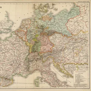
Framed Print : Map of Central Europe, World War One


![]()
Framed Photos from Mary Evans Picture Library
Map of Central Europe, World War One
Map of Central Europe in World War One, showing the Principal Theatre of War. Date: World War One
Mary Evans Picture Library makes available wonderful images created for people to enjoy over the centuries
Media ID 14125848
© Mary Evans Picture Library/PHILIP TALMAGE
Austria Countries Denmark Holland Hungary Maps
21.5"x17.5" (55x44cm) Premium Frame
Step back in time with our stunning Framed Prints from the Media Storehouse collection, featuring this captivating Map of Central Europe during World War One. Meticulously sourced from Mary Evans Prints Online, this rights-managed image provides an intriguing glimpse into the Principal Theatre of War during this pivotal historical period. This beautifully framed print makes for an exceptional addition to any office, library, or history enthusiast's home, transporting you back to the events of World War One with every glance.
Framed and mounted 17x12 print. Professionally handmade full timber moulded frames are finished off with framers tape and come with a hanging solution on the back. Outer dimensions are 21.5x17.5 inches (546x444mm). Quality timber frame frame moulding (20mm wide and 30mm deep) with frame colours in your choice of black, white, or raw oak and a choice of black or white card mounts. Frames have a perspex front providing a virtually unbreakable glass-like finish which is easily cleaned with a damp cloth.
Contemporary Framed and Mounted Prints - Professionally Made and Ready to Hang
Estimated Image Size (if not cropped) is 41.8cm x 41.8cm (16.5" x 16.5")
Estimated Product Size is 54.6cm x 44.4cm (21.5" x 17.5")
These are individually made so all sizes are approximate
Artwork printed orientated as per the preview above, with landscape (horizontal) or portrait (vertical) orientation to match the source image.
FEATURES IN THESE COLLECTIONS
> Europe
> Austria
> Related Images
> Europe
> Belgium
> Related Images
> Europe
> Denmark
> Related Images
EDITORS COMMENTS
This map print depicts Central Europe during the tumultuous period of World War One, from 1914 to 1918. The intricate details of the map reveal the principal theatre of war, with Germany, Austria-Hungary, and their allies occupying the eastern and central parts, while France, Belgium, Holland, and their allies hold the western front. Denmark, situated to the north, remained neutral throughout the conflict. The map serves as a poignant reminder of the complex geopolitical landscape of the time, as well as the devastating impact of the war on European countries. The intricate borders and territorial claims that once defined this region were redrawn, leading to significant political and social upheaval. The map's title, "Map of Central Europe in World War One," is inscribed in elegant script at the top, while the date range, "1914-1918," is displayed prominently at the bottom. The map's historical significance is further emphasized by the use of shading to highlight the various theatres of war and the inclusion of an inset map of the Eastern Front. As we study this map, we are transported back in time to an era of profound change and upheaval. The map serves as a visual testament to the sacrifices made by millions of people during the war, and a reminder of the enduring importance of peace and diplomacy in resolving international conflicts.
MADE IN AUSTRALIA
Safe Shipping with 30 Day Money Back Guarantee
FREE PERSONALISATION*
We are proud to offer a range of customisation features including Personalised Captions, Color Filters and Picture Zoom Tools
SECURE PAYMENTS
We happily accept a wide range of payment options so you can pay for the things you need in the way that is most convenient for you
* Options may vary by product and licensing agreement. Zoomed Pictures can be adjusted in the Cart.