Framed Print > Historic > Ancient civilizations > Ancient Greece > Greek history
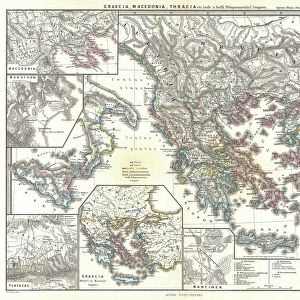
Framed Print : Map of the Macedonian and Thracian Empire


![]()
Framed Photos from Mary Evans Picture Library
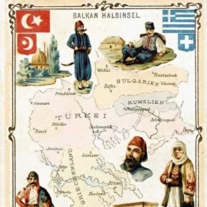
Map of the Macedonian and Thracian Empire
Map of the Macedonian and Thracian Empire. Date: 1808
Mary Evans Picture Library makes available wonderful images created for people to enjoy over the centuries
Media ID 11575337
© Mary Evans / Grenville Collins Postcard Collection
1808 Aegean Balkan Balkans Byzantium Chart Dacia Epirus Illyria Ionian Macedonia Macedonian Maps Thracian
13.5"x11.5" (34x29cm) Premium Frame
Discover the rich history of the ancient Macedonian and Thracian Empire with our stunning Framed Prints from Media Storehouse. This exquisite map, dated 1808, is sourced from Mary Evans Prints Online and showcases the vast territories ruled by legendary leaders like Alexander the Great. Each print is meticulously framed in a contemporary style, enhancing the intricate details of the map and adding a touch of sophistication to any room. Bring history to life in your home or office with this impressive and educational piece.
Framed and mounted 9x7 print. Professionally handmade full timber moulded frames are finished off with framers tape and come with a hanging solution on the back. Outer dimensions are 13.5x11.5 inches (34x29cm). Quality timber frame frame moulding (20mm wide and 30mm deep) with frame colours in your choice of black, white, or raw oak and a choice of black or white card mounts. Frames have a perspex front providing a virtually unbreakable glass-like finish which is easily cleaned with a damp cloth.
Contemporary Framed and Mounted Prints - Professionally Made and Ready to Hang
Estimated Image Size (if not cropped) is 21.4cm x 21.4cm (8.4" x 8.4")
Estimated Product Size is 34cm x 29.2cm (13.4" x 11.5")
These are individually made so all sizes are approximate
Artwork printed orientated as per the preview above, with landscape (horizontal) or portrait (vertical) orientation to match the source image.
FEATURES IN THESE COLLECTIONS
> Europe
> Greece
> Related Images
> Europe
> Macedonia
> Posters
> Europe
> Macedonia
> Related Images
> Europe
> Related Images
> Historic
> Ancient civilizations
> Ancient Greece
> Greek history
> Maps and Charts
> Early Maps
EDITORS COMMENTS
This map print, dated 1808, offers a glimpse into the rich historical tapestry of the Macedonian and Thracian Empire, a vast territory that once stretched across Central Europe and the Balkan Peninsula. The map meticulously delineates the borders of ancient civilizations, including Macedonia, Thrace, Epirus, Thessalia, Illyrium, Dacia, and more. Macedonia, located in the northern part of the map, was a significant ancient kingdom that flourished from the 8th to the 14th centuries BC. It was renowned for its powerful rulers, such as Alexander the Great, who expanded the Macedonian Empire to include much of the ancient world. Thrace, situated to the east, was a diverse region inhabited by various tribes, including the Thracians, who were known for their warrior culture and gold mining. Thessalia, to the west, was a fertile plain that was a center of Greek civilization. Illyrium, to the south, was a region inhabited by the Illyrians, who were known for their resistance to Roman rule. Dacia, located north of the Danube River, was a powerful and prosperous kingdom that was annexed by the Romans in AD 106. The map also highlights key geographical features, such as the Aegean Sea, the Ionian Sea, and the Byzantium Straits. These bodies of water played crucial roles in the economic and cultural exchange between the various civilizations of the region. This map is an invaluable resource for anyone interested in ancient history, particularly the history of Central Europe and the Balkans. It provides a fascinating glimpse into the complex and interconnected world of ancient civilizations and offers a reminder of the rich cultural heritage that continues to shape our world today.
MADE IN AUSTRALIA
Safe Shipping with 30 Day Money Back Guarantee
FREE PERSONALISATION*
We are proud to offer a range of customisation features including Personalised Captions, Color Filters and Picture Zoom Tools
SECURE PAYMENTS
We happily accept a wide range of payment options so you can pay for the things you need in the way that is most convenient for you
* Options may vary by product and licensing agreement. Zoomed Pictures can be adjusted in the Cart.