Framed Print > Europe > Netherlands > Maps
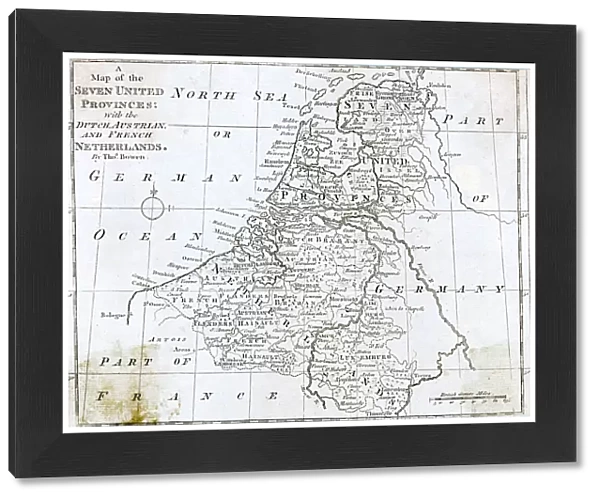
Framed Print : MAP / NETHERLANDS 1788
![]()

Framed Photos from Mary Evans Picture Library
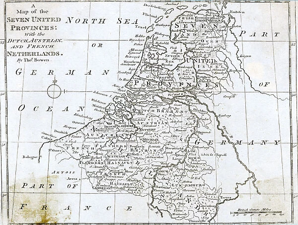
MAP / NETHERLANDS 1788
Map of the Seven United Provinces, with the Dutch, Austrian and French Netherlands Date: 1788
Mary Evans Picture Library makes available wonderful images created for people to enjoy over the centuries
Media ID 20153869
© Bubblepunk
1788 Austrian Maps Netherlands Provinces
21.5"x17.5" (55x44cm) Premium Frame
Discover the rich history of the Netherlands with our exquisite Framed Prints from Media Storehouse, featuring the detailed and captivating "MAP / NETHERLANDS 1788" from Mary Evans Prints Online. This antique map, dated 1788, showcases the Seven United Provinces, highlighting the Dutch, Austrian, and French Netherlands. Bring a piece of historical cartography into your home or office with this beautifully framed and preserved print, adding an air of sophistication and intrigue to any space. Order now and travel back in time with every glance.
Framed and mounted 17x12 print. Professionally handmade full timber moulded frames are finished off with framers tape and come with a hanging solution on the back. Outer dimensions are 21.5x17.5 inches (546x444mm). Quality timber frame frame moulding (20mm wide and 30mm deep) with frame colours in your choice of black, white, or raw oak and a choice of black or white card mounts. Frames have a perspex front providing a virtually unbreakable glass-like finish which is easily cleaned with a damp cloth.
Contemporary Framed and Mounted Prints - Professionally Made and Ready to Hang
Estimated Image Size (if not cropped) is 41.8cm x 41.8cm (16.5" x 16.5")
Estimated Product Size is 54.6cm x 44.4cm (21.5" x 17.5")
These are individually made so all sizes are approximate
Artwork printed orientated as per the preview above, with landscape (horizontal) or portrait (vertical) orientation to match the source image.
FEATURES IN THESE COLLECTIONS
> Europe
> Austria
> Related Images
> Europe
> Netherlands
> Maps
> Europe
> Netherlands
> Posters
> Europe
> Netherlands
> Related Images
> Europe
> Related Images
> Mary Evans Prints Online
> New Images July 2020
EDITORS COMMENTS
This stunning map print, titled "Map of the Seven United Provinces, with the Dutch, Austrian and French Netherlands," dates back to 1788. The map provides a detailed and intricate depiction of Europe during a pivotal moment in its history. The Seven United Provinces, also known as the Dutch Republic, are prominently featured in the map, occupying the central and northern regions of the modern-day Netherlands. The map also highlights the Austrian and French territories, reflecting the complex political landscape of the time. The Austrian Netherlands, ruled by the Habsburg Monarchy, are shown to the south, while the French Netherlands, or the Austrian Netherlands under French control, are depicted to the southeast. The map also includes the Prussian territories, the Rhine River, and the North Sea. The intricate detail of this map is truly remarkable, with cities, towns, and villages marked with precision. The map also includes topographical features, such as mountains, forests, and bodies of water. The cartouche, or decorative border, features an elaborate design of a Dutch windmill, symbolizing the importance of the windmill industry in the Netherlands during this period. This map provides a fascinating glimpse into the political and geographical landscape of Europe during the late 18th century. The intricate detail and beautiful design make it a valuable addition to any collection of historical maps or European studies. The map also serves as a reminder of the complex political alliances and territorial disputes that shaped Europe during this period, as well as the importance of the Netherlands as a major European power.
MADE IN AUSTRALIA
Safe Shipping with 30 Day Money Back Guarantee
FREE PERSONALISATION*
We are proud to offer a range of customisation features including Personalised Captions, Color Filters and Picture Zoom Tools
SECURE PAYMENTS
We happily accept a wide range of payment options so you can pay for the things you need in the way that is most convenient for you
* Options may vary by product and licensing agreement. Zoomed Pictures can be adjusted in the Cart.

