Framed Print : Trench maps belonging to Sergeant Ernest Blaikley


![]()
Framed Photos from Mary Evans Picture Library
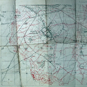
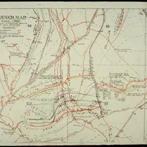
Trench maps belonging to Sergeant Ernest Blaikley
Trench maps belonging to 2903 Sergeant ERNEST BLAIKLEY, 28th Battalion London Regiment (Artists Rifles) (1885-1965). Attached S.O. & S. School (Sniping, Observation and Scouting School) at Linghem, Hesdin and Senlis.1. Trench map of France, Sheet 51C, 1/40, 000, First Edition (Arras/Albert). 2. Trench maps, 36 NE and 36a SW. 3. Trench map - 1/10, 000 dated January 1917 (Auchy-la-Bass饬 Hulluch). 4. Plan de la ville, Arras. Collection
Mary Evans Picture Library makes available wonderful images created for people to enjoy over the centuries
Media ID 14150641
© David Cohen Fine Art/Mary Evans Picture Library
10000 1885 1965 28th 2903 40000 Arras Attached Auchy Bass Bassae Battalion Belonging Dated Edition Ernest First Hesdin Hulluch Maps Observation Plan Regiment Rifles Sergeant Sheet Sniping Trench Ville Albert Blaikley January Scouting
13.5"x11.5" (34x29cm) Premium Frame
Introducing the limited-edition Framed Prints from Media Storehouse, featuring an intriguing historical image of "Trench Maps Belonging to Sergeant Ernest Blaikley." This captivating piece, rights-managed through Mary Evans Prints Online, offers a unique glimpse into the past. Sergeant Ernest Blaikley (1885-1965), a member of the 28th Battalion London Regiment (Artists Rifles), is seen in this image with his collection of trench maps. These maps, meticulously spread on a table, offer a testament to the strategic efforts and dedication of soldiers during wartime. Bring this piece of history into your home or office with our high-quality Framed Prints. Each print is carefully crafted using premium materials to ensure the vibrant colors and intricate details of the image are preserved. Add a touch of historical significance to your space with the Trench Maps Belonging to Sergeant Ernest Blaikley Framed Print. Order yours today and let the story of this brave soldier inspire you every day.
Framed and mounted 9x7 print. Professionally handmade full timber moulded frames are finished off with framers tape and come with a hanging solution on the back. Outer dimensions are 13.5x11.5 inches (34x29cm). Quality timber frame frame moulding (20mm wide and 30mm deep) with frame colours in your choice of black, white, or raw oak and a choice of black or white card mounts. Frames have a perspex front providing a virtually unbreakable glass-like finish which is easily cleaned with a damp cloth.
Contemporary Framed and Mounted Prints - Professionally Made and Ready to Hang
Estimated Image Size (if not cropped) is 21.4cm x 21.4cm (8.4" x 8.4")
Estimated Product Size is 34cm x 29.2cm (13.4" x 11.5")
These are individually made so all sizes are approximate
Artwork printed orientated as per the preview above, with landscape (horizontal) or portrait (vertical) orientation to match the source image.
EDITORS COMMENTS
This collection of trench maps belonged to 2903 Sergeant Ernest Blaikley of the 28th Battalion London Regiment (Artists Rifles). Ernest served as an Attached Staff Officer and Instructor at the Sniping, Observation and Scouting School in Linghem, Hesdin, and Senlis during World War I. The maps provide insight into the complex network of trenches and fortifications in the Arras and Albert regions of France. The first map, Sheet 51C, 1/40,000, First Edition, covers the Arras and Albert area, providing a comprehensive overview of the battlefield. The second pair of maps, 36 NE and 36a SW, offer more detailed views of specific areas, likely used for targeted reconnaissance and planning. The final map, 1/10,000, dated January 1917, focuses on the area around Auchy-la-Bassée and Hulluch, providing a precise and up-to-date representation of the battlefield at a critical time in the war. The Plan de la ville, Arras, further illustrates the importance of detailed mapping during this period. These maps would have been essential tools for Ernest and his students as they honed their skills in sniping, observation, and scouting, contributing to the Allied war effort in the trenches of France.
MADE IN AUSTRALIA
Safe Shipping with 30 Day Money Back Guarantee
FREE PERSONALISATION*
We are proud to offer a range of customisation features including Personalised Captions, Color Filters and Picture Zoom Tools
SECURE PAYMENTS
We happily accept a wide range of payment options so you can pay for the things you need in the way that is most convenient for you
* Options may vary by product and licensing agreement. Zoomed Pictures can be adjusted in the Cart.