Framed Print > North America > United States of America > Virginia > Alexandria
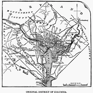
Framed Print : Washington DC during the Civil War


![]()
Framed Photos from North Wind
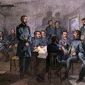
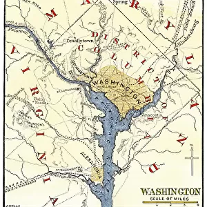
Washington DC during the Civil War
Map of the Washington DC vicinity at the outset of the Civil War.
Hand-colored woodcut of a 19th century-illustration
North Wind Picture Archives brings history to life with stock images and hand-colored illustrations
Media ID 5879756
© North Wind Picture Archives
1860s Alexandria America Potomac River Virginia Washington Dc
13.5"x11.5" (34x29cm) Premium Frame
Step back in time with our stunning Framed Print from Media Storehouse, featuring a captivating image of Washington DC during the Civil War. This beautiful hand-colored woodcut, sourced from North Wind Picture Archives, transports you to the 19th century with intricate detail and authenticity. The map of the Washington DC vicinity at the outset of the Civil War adds historical context, making this print an essential addition to any home or office. Preserve this piece of history and add character to your space with our high-quality framing options. Order now and rediscover the past.
Framed and mounted 9x7 print. Professionally handmade full timber moulded frames are finished off with framers tape and come with a hanging solution on the back. Outer dimensions are 13.5x11.5 inches (34x29cm). Quality timber frame frame moulding (20mm wide and 30mm deep) with frame colours in your choice of black, white, or raw oak and a choice of black or white card mounts. Frames have a perspex front providing a virtually unbreakable glass-like finish which is easily cleaned with a damp cloth.
Contemporary Framed and Mounted Prints - Professionally Made and Ready to Hang
Estimated Image Size (if not cropped) is 21.4cm x 21.4cm (8.4" x 8.4")
Estimated Product Size is 29.2cm x 34cm (11.5" x 13.4")
These are individually made so all sizes are approximate
Artwork printed orientated as per the preview above, with landscape (horizontal) or portrait (vertical) orientation to match the source image.
FEATURES IN THESE COLLECTIONS
> Arts
> Landscape paintings
> Waterfall and river artworks
> River artworks
> North America
> Related Images
> North America
> United States of America
> Virginia
> Alexandria
> North Wind Picture Archives
> Civil War (US)
> North Wind Picture Archives
> Maps
EDITORS COMMENTS
This print takes us back in time to the tumultuous era of the American Civil War. The hand-colored woodcut, created in the 19th century, showcases a map of Washington DC and its vicinity at the outset of this historic conflict. With its vintage charm and intricate details, this illustration offers a glimpse into the rich heritage and traditional artistry of that era. The map depicts an aerial view of Washington DC, nestled along the banks of the Potomac River. It highlights key landmarks such as Alexandria in Virginia, which played a significant role during this period. As we study this piece closely, we can almost feel ourselves transported to those uncertain times when our nation was divided. Through this image, we are reminded of America's complex history and how it has shaped our present-day society. It serves as a visual testament to the struggles faced by our ancestors and their unwavering determination for freedom and unity. As we admire this remarkable piece from North Wind Picture Archives, let us reflect on how far we have come as a nation since those turbulent days. May it inspire us to cherish our shared values and continue striving towards progress while honoring our past.
MADE IN AUSTRALIA
Safe Shipping with 30 Day Money Back Guarantee
FREE PERSONALISATION*
We are proud to offer a range of customisation features including Personalised Captions, Color Filters and Picture Zoom Tools
SECURE PAYMENTS
We happily accept a wide range of payment options so you can pay for the things you need in the way that is most convenient for you
* Options may vary by product and licensing agreement. Zoomed Pictures can be adjusted in the Cart.