Framed Print : Early map of the Moon, 1772
![]()

Framed Photos from Science Photo Library
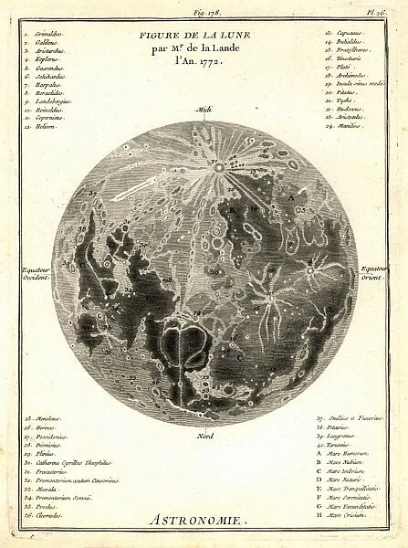
Early map of the Moon, 1772
Map of the Moon, by De La Lande, in 1772. This early French engraving of the Moon charts its geographical features using the system created by Giovanni Riccioli (1598-1671), which has features named after famous scientists and people
Science Photo Library features Science and Medical images including photos and illustrations
Media ID 6431329
© DETLEV VAN RAVENSWAAY/SCIENCE PHOTO LIBRARY
1700s 1772 18th Century Chart Lunar Moon Night Sky Solar System
21.5"x17.5" (55x44cm) Premium Frame
Step back in time with our captivating Framed Prints from the Media Storehouse collection. This early map of the Moon, dating back to 1772, showcases the lunar landscape as depicted in the engraving by De La Lande. Based on the geographical system created by Giovanni Riccioli, this fascinating piece offers a unique glimpse into the history of lunar exploration. Add an element of historical charm to your space with this intricately detailed and beautifully framed print.
Framed and mounted 17x12 print. Professionally handmade full timber moulded frames are finished off with framers tape and come with a hanging solution on the back. Outer dimensions are 21.5x17.5 inches (546x444mm). Quality timber frame frame moulding (20mm wide and 30mm deep) with frame colours in your choice of black, white, or raw oak and a choice of black or white card mounts. Frames have a perspex front providing a virtually unbreakable glass-like finish which is easily cleaned with a damp cloth.
Contemporary Framed and Mounted Prints - Professionally Made and Ready to Hang
Estimated Image Size (if not cropped) is 41.8cm x 41.8cm (16.5" x 16.5")
Estimated Product Size is 44.4cm x 54.6cm (17.5" x 21.5")
These are individually made so all sizes are approximate
Artwork printed orientated as per the preview above, with landscape (horizontal) or portrait (vertical) orientation to match the source image.
EDITORS COMMENTS
This print showcases an early map of the Moon, dating back to 1772. Created by De La Lande, a French engraver, this exquisite piece of art depicts the lunar surface and its geographical features using the innovative system developed by Giovanni Riccioli in the seventeenth century. Riccioli's system involved naming various lunar formations after renowned scientists and influential figures. The intricate details captured in this historical illustration offer a glimpse into our understanding of astronomy during the eighteenth century. It serves as a testament to humanity's enduring fascination with space exploration and our relentless pursuit to unravel the mysteries of the universe. As we gaze upon this remarkable artwork, we are transported back in time to an era when scientific knowledge was expanding rapidly. The map not only provides valuable insights into how astronomers perceived our celestial neighbor centuries ago but also highlights their dedication to mapping and comprehending distant worlds. With its delicate lines and meticulous craftsmanship, this lunar chart stands as a testament to both artistic skill and scientific curiosity. It reminds us that even before modern technology allowed us to explore space firsthand, humans were already striving to understand and appreciate the wonders that lie beyond our own planet. In preserving this significant piece of history through photography, Science Photo Library allows us all to marvel at mankind's quest for knowledge while honoring those who paved the way for future astronomical discoveries.
MADE IN AUSTRALIA
Safe Shipping with 30 Day Money Back Guarantee
FREE PERSONALISATION*
We are proud to offer a range of customisation features including Personalised Captions, Color Filters and Picture Zoom Tools
SECURE PAYMENTS
We happily accept a wide range of payment options so you can pay for the things you need in the way that is most convenient for you
* Options may vary by product and licensing agreement. Zoomed Pictures can be adjusted in the Cart.


