Framed Print > Africa > Equatorial Guinea > Maps
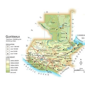
Framed Print : Map of Equatorial Guinea


![]()
Framed Photos from Universal Images Group (UIG)
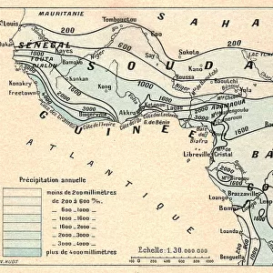
Map of Equatorial Guinea
Universal Images Group (UIG) manages distribution for many leading specialist agencies worldwide
Media ID 9539983
© Dorling Kindersley/UIG
Africa Borders Country Equatorial Guinea West Africa
13.5"x11.5" (34x29cm) Premium Frame
Discover the intricacies of Equatorial Guinea with our exquisitely framed Map of Equatorial Guinea by Dorling Kindersley from Universal Images Group (UIG). This captivating framed print showcases detailed cartography, making it an essential addition to any world exploration-themed room or office space. The high-quality frame enhances the vivid colors and fine lines of the map, ensuring a stunning visual display. Travel the world from the comfort of your home and expand your geographical knowledge with this beautiful and informative piece.
Framed and mounted 9x7 print. Professionally handmade full timber moulded frames are finished off with framers tape and come with a hanging solution on the back. Outer dimensions are 13.5x11.5 inches (34x29cm). Quality timber frame frame moulding (20mm wide and 30mm deep) with frame colours in your choice of black, white, or raw oak and a choice of black or white card mounts. Frames have a perspex front providing a virtually unbreakable glass-like finish which is easily cleaned with a damp cloth.
Contemporary Framed and Mounted Prints - Professionally Made and Ready to Hang
Estimated Image Size (if not cropped) is 21.4cm x 21.4cm (8.4" x 8.4")
Estimated Product Size is 29.2cm x 34cm (11.5" x 13.4")
These are individually made so all sizes are approximate
Artwork printed orientated as per the preview above, with landscape (horizontal) or portrait (vertical) orientation to match the source image.
FEATURES IN THESE COLLECTIONS
> Africa
> Equatorial Guinea
> Maps
> Africa
> Equatorial Guinea
> Related Images
> Africa
> Guinea
> Related Images
> Maps and Charts
> Related Images
> Universal Images Group (UIG)
> Illustrations
> Illustrations 1
EDITORS COMMENTS
This vibrant and detailed print showcases the captivating "Map of Equatorial Guinea" by Dorling Kindersley, a renowned publisher of atlases and travel guides. The image beautifully captures the essence of this West African country, with its rich geography and diverse landscapes. The map itself is a true work of art, meticulously crafted to provide an accurate representation of Equatorial Guinea's borders and topography. Every detail has been carefully rendered in vivid colors, making it visually appealing and engaging for any viewer. Equatorial Guinea, nestled on the western coast of Africa, comes alive through this cartographic masterpiece. From its stunning coastline along the Atlantic Ocean to its lush rainforests teeming with biodiversity, this small nation offers a wealth of natural wonders waiting to be explored. Beyond its geographical features, Equatorial Guinea holds immense cultural significance as well. With multiple ethnic groups coexisting harmoniously within its borders, it boasts a rich tapestry of traditions and customs that contribute to its unique identity. Whether you are an avid traveler or simply fascinated by maps and cartography, this print is sure to captivate your imagination. It serves as both an educational tool for understanding Equatorial Guinea's geography and a beautiful piece of artwork that can enhance any space with its vibrant colors.
MADE IN AUSTRALIA
Safe Shipping with 30 Day Money Back Guarantee
FREE PERSONALISATION*
We are proud to offer a range of customisation features including Personalised Captions, Color Filters and Picture Zoom Tools
SECURE PAYMENTS
We happily accept a wide range of payment options so you can pay for the things you need in the way that is most convenient for you
* Options may vary by product and licensing agreement. Zoomed Pictures can be adjusted in the Cart.