Framed Print > Universal Images Group (UIG) > Universal Images Group > Satellite and Aerial > Planet Observer 4
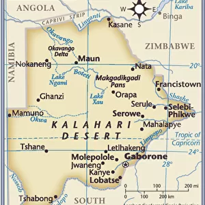
Framed Print : Botswana, Relief Map With Border and Mask


![]()
Framed Photos from Universal Images Group (UIG)
Botswana, Relief Map With Border and Mask
Relief map of Botswana (with border and mask). This image was compiled from data acquired by landsat 5 & 7 satellites combined with elevation data
Universal Images Group (UIG) manages distribution for many leading specialist agencies worldwide
Media ID 9618759
© Planet Observer/UIG
Africa Botswana Desert Relief Map Kalahari Desert Satellite View
A2 Premium Frame with A3 Poster
Discover the beauty and complexity of Botswana with our Framed Prints from Media Storehouse. This stunning relief map, sourced from Universal Images Group (UIG), provides a unique perspective of Botswana's borders and topography. Compiled from satellite data acquired by Landsat 5 & 7 and elevation data, this print offers intricate detail and accuracy. Elevate the look of your space with this captivating and educational addition.
Premium Paradise Wooden Range A2 Premium Poster Frame (62x45cm) with A3 Poster (42x30cm) and mounted behind a white matt board to make your photo really stand out. FSC Certified and Rainforest Alliance Certified for environmental, social, and economic sustainably. High transparency tempered glass window with a smooth finished frame. Great for filling empty walls, decorating blank spaces, or creating eye-catching gallery walls. Frames arrive ready to hang. Sent with secure, protective packaging. Smooth wooden veneer mimics the real wood look and feel with ultra-durable scratch resistance tempered glass.
Contemporary Framed and Mounted Prints - Professionally Made and Ready to Hang
Estimated Image Size (if not cropped) is 40.4cm x 40.4cm (15.9" x 15.9")
Estimated Product Size is 44.6cm x 62cm (17.6" x 24.4")
These are individually made so all sizes are approximate
Artwork printed orientated as per the preview above, with landscape (horizontal) or portrait (vertical) orientation to match the source image.
EDITORS COMMENTS
This print showcases the stunning relief map of Botswana, a landlocked country located in southern Africa. The intricate details and vibrant colors make this image truly mesmerizing. Compiled from data acquired by Landsat 5 & 7 satellites combined with elevation data, it provides an accurate representation of the topography and physical geography of Botswana. The vast expanse of the Kalahari Desert dominates a significant portion of the map, its golden hues contrasting beautifully against other regions. From towering sand dunes to expansive plains, this desert is a prominent feature that shapes Botswana's landscape. Gaborone, the capital city, can be spotted on this relief map as well. Nestled amidst rolling hills and surrounded by lush vegetation, Gaborone stands out as a bustling urban center amidst nature's grandeur. With no people visible in the photograph, one can fully appreciate the untouched beauty and raw wilderness that defines Botswana. This satellite view offers a unique perspective on cartography and serves as an invaluable resource for researchers and enthusiasts alike. Whether you are fascinated by geography or simply captivated by breathtaking landscapes, this print is sure to transport you to the heart of Botswana's natural wonders. It serves as a reminder of our planet's diverse beauty while showcasing Universal Images Group (UIG)'s commitment to capturing extraordinary moments without commercial intent.
MADE IN AUSTRALIA
Safe Shipping with 30 Day Money Back Guarantee
FREE PERSONALISATION*
We are proud to offer a range of customisation features including Personalised Captions, Color Filters and Picture Zoom Tools
SECURE PAYMENTS
We happily accept a wide range of payment options so you can pay for the things you need in the way that is most convenient for you
* Options may vary by product and licensing agreement. Zoomed Pictures can be adjusted in the Cart.