Fraud Blocker Skip to main content

Climatological Collection

"Exploring the Climates of our Planet: From Antarctica to Typhoons" Water vapour maps of Antarctica

Background imageClimatological Collection: Water vapour maps of Antarctica, 2004

Water vapour maps of Antarctica, 2004
Water vapour maps of Antarctica. Satellite images of the increase in water vapour over Antarctica from 13 August to 14 October 2004 (the austral spring)

Background imageClimatological Collection: Northern Corries at dawn

Northern Corries at dawn. View looking west just before sunrise across Coire an t-Sneachda (hollow area) to Coire Lochain. The ridge separating the two hollows is is the Fiacaill Ridge

Background imageClimatological Collection: Orbiting Carbon Observatory, artwork

Orbiting Carbon Observatory, artwork
Orbiting Carbon Observatory (OCO) in Earth orbit, artwork. A NASA mission, the OCO was designed to make global measurements of levels of the greenhouse gas carbon dioxide

Background imageClimatological Collection: Wilkins Ice Shelf, Antarctica

Wilkins Ice Shelf, Antarctica
Wilkins Ice Shelf. Satellite image showing the location of the Wilkins Ice Shelf (just above and right of centre) on the Antarctic Peninsula

Background imageClimatological Collection: Snowball Earth, artwork C018 / 8568

Snowball Earth, artwork C018 / 8568
Snowball Earth, artwork

Background imageClimatological Collection: Earth supercontinents, artwork C015 / 1916

Earth supercontinents, artwork C015 / 1916
Earth supercontinents. Artwork showing three of the supercontinents that have formed during the history of the Earth. From top to bottom, and oldest to youngest

Background imageClimatological Collection: Typhoon Tokage

Typhoon Tokage. Satellite image of Typhoon Tokage (centre) hitting the western coast of Japan (upper left) on 19 October 2004 at 0215 GMT. The typhoon produced winds of 225 kilometres per hour

Background imageClimatological Collection: Eroded statue

Eroded statue. Stone statue that has been damaged by acid rain. Acid rain is caused by the reaction in the atmosphere between water droplets and pollutant gases

Background imageClimatological Collection: Cretaceous-Tertiary extinction event

Cretaceous-Tertiary extinction event. Image 3 of 8. Artwork of an asteroid burning up in a fireball as it passes through the Earths atmosphere. A Quetzalcoatlus pterosaur is seen in the foreground

Background imageClimatological Collection: Sea surface salinity, Aquarius image C017 / 6816

Sea surface salinity, Aquarius image C017 / 6816
Sea surface salinity, Aquarius image. Computer model showing the salinity (dissolved salt-content) of the Atlantic Ocean, based on information recorded by the Aquarius spacecraft from December 2011

Background imageClimatological Collection: Perito Moreno Glacier, Argentina F008 / 3645

Perito Moreno Glacier, Argentina F008 / 3645
Perito Moreno Glacier. View of the Perito Moreno Glacier, Los Glaciares National Park, Santa Cruz Province, Patagonia, Argentina

Background imageClimatological Collection: Perito Moreno Glacier, Argentina F008 / 3643

Perito Moreno Glacier, Argentina F008 / 3643
Perito Moreno Glacier. View of the Perito Moreno Glacier, Los Glaciares National Park, Santa Cruz Province, Patagonia, Argentina

Background imageClimatological Collection: Perito Moreno Glacier, Argentina F008 / 3654

Perito Moreno Glacier, Argentina F008 / 3654
Perito Moreno Glacier. View of the Perito Moreno Glacier, Los Glaciares National Park, Santa Cruz Province, Patagonia, Argentina

Background imageClimatological Collection: Perito Moreno Glacier, Argentina F008 / 3652

Perito Moreno Glacier, Argentina F008 / 3652
Erito Moreno Glacier. View of the Perito Moreno Glacier, Los Glaciares National Park, Santa Cruz Province, Patagonia, Argentina

Background imageClimatological Collection: Perito Moreno Glacier, Argentina F008 / 3612

Perito Moreno Glacier, Argentina F008 / 3612
Perito Moreno Glacier. View of the Perito Moreno Glacier, Los Glaciares National Park, Santa Cruz Province, Patagonia, Argentina

Background imageClimatological Collection: Perito Moreno Glacier, Argentina F008 / 3610

Perito Moreno Glacier, Argentina F008 / 3610
Perito Moreno Glacier. View of the Perito Moreno Glacier, Los Glaciares National Park, Santa Cruz Province, Patagonia, Argentina

Background imageClimatological Collection: Perito Moreno Glacier, Argentina C014 / 1006

Perito Moreno Glacier, Argentina C014 / 1006
Perito Moreno Glacier. View over the surface of the Perito Moreno Glacier, Los Glaciares National Park, Santa Cruz Province, Patagonia, Argentina

Background imageClimatological Collection: Pia Glacier, Chile C014 / 1009

Pia Glacier, Chile C014 / 1009
Pia Glacier. View towards the face of the Pia Glacier (centre) in the Cordillera Darwin mountains, Tierra del Fuego, Patagonia, Chile

Background imageClimatological Collection: Perito Moreno Glacier, Argentina C014 / 1005

Perito Moreno Glacier, Argentina C014 / 1005
Perito Moreno Glacier. View of the Perito Moreno Glacier, Los Glaciares National Park, Santa Cruz Province, Patagonia, Argentina

Background imageClimatological Collection: European glaciation, artwork

European glaciation, artwork
European glaciation. Artwork showing the maximum extent of the ice sheets and glaciers at the peak of the last Ice Age, between 20, 000 and 18, 000 years ago

Background imageClimatological Collection: Arctic ice minimum extent, 2012

Arctic ice minimum extent, 2012
Arctic ice minimum extent. Satellite image showing the Arctic polar ice cap at its annual minimum extent on 16th September 2012

Background imageClimatological Collection: Sea surface salinity, Aquarius image C017 / 6820

Sea surface salinity, Aquarius image C017 / 6820
Sea surface salinity, Aquarius image. Computer model showing the salinity (dissolved salt-content) of the oceans around Africa

Background imageClimatological Collection: Perito Moreno Glacier, Argentina C014 / 1008

Perito Moreno Glacier, Argentina C014 / 1008
Perito Moreno Glacier. View of the face of the Perito Moreno Glacier, Los Glaciares National Park, Santa Cruz Province, Patagonia, Argentina

Background imageClimatological Collection: Perito Moreno Glacier, Argentina C014 / 1007

Perito Moreno Glacier, Argentina C014 / 1007
Perito Moreno Glacier. View over the surface of the Perito Moreno Glacier, Los Glaciares National Park, Santa Cruz Province, Patagonia, Argentina

Background imageClimatological Collection: Columbia Glacier, Alaska, 1989

Columbia Glacier, Alaska, 1989
Columbia Glacier, Alaska. False-colour satellite image of the Columbia Glacier, Alaska, USA, taken in 1989. Columbia Glacier descends from an ice field (top) 3, 050 metres above sea level

Background imageClimatological Collection: Meteosat weather satellite, artwork C017 / 7338

Meteosat weather satellite, artwork C017 / 7338
Meteosat weather satellite. Computer artwork of a Meteosat weather satellite, showing the external structure (top left) and main components (right)

Background imageClimatological Collection: Meteosat weather satellite, artwork C017 / 7339

Meteosat weather satellite, artwork C017 / 7339
Meteosat weather satellite. Computer artwork of a Meteosat weather satellite, showing the external structure (top left) and main components (right)

Background imageClimatological Collection: Arctic ice minimum extent, 2013 C017 / 3623

Arctic ice minimum extent, 2013 C017 / 3623
Arctic ice minimum extent. Satellite image showing the Arctic polar ice cap at its annual minimum extent on 12th September 2013

Background imageClimatological Collection: Perito Moreno Glacier, Argentina C014 / 1004

Perito Moreno Glacier, Argentina C014 / 1004
Perito Moreno Glacier. View of the face of the Perito Moreno Glacier, Los Glaciares National Park, Santa Cruz Province, Patagonia, Argentina

Background imageClimatological Collection: Glaciology at Mont Blanc weather station C016 / 9625

Glaciology at Mont Blanc weather station C016 / 9625
Glaciology at Mont Blanc weather station. Glaciologist obtaining an ice core at the weather station on the col of the Dome du Gouter, a peak that is a shoulder of Mont Blanc

Background imageClimatological Collection: Glaciology at Mont Blanc weather station C016 / 9624

Glaciology at Mont Blanc weather station C016 / 9624
Glaciology at Mont Blanc weather station. Glaciologist checking instrument readings at the weather station on the col of the Dome du Gouter, a peak that is a shoulder of Mont Blanc

Background imageClimatological Collection: Glaciology research, Argentiere Glacier C016 / 9623

Glaciology research, Argentiere Glacier C016 / 9623
Glaciology research. Researcher using a laptop computer to access and study photography of glacier movements. This is the Argentiere Glacier in the French Alps

Background imageClimatological Collection: Glaciology at Mont Blanc weather station C016 / 9626

Glaciology at Mont Blanc weather station C016 / 9626
Glaciology at Mont Blanc weather station. Glaciologist checking instrument readings at the weather station on the col of the Dome du Gouter, a peak that is a shoulder of Mont Blanc

Background imageClimatological Collection: Cloud cover climate change, artwork

Cloud cover climate change, artwork
Cloud cover climate change. Artwork showing climate change in the form of lowered temperatures due to increased cloud formation

Background imageClimatological Collection: Global warming in the Arctic, artwork C016 / 6300

Global warming in the Arctic, artwork C016 / 6300
Global warming. Conceptual artwork of a polar bear (Ursus maritimus) on a disintegrating ice floe, representing an Arctic affected by global warming

Background imageClimatological Collection: Perito Moreno Glacier, Argentina C018 / 0086

Perito Moreno Glacier, Argentina C018 / 0086
Perito Moreno Glacier. View of the face of the Perito Moreno Glacier, Los Glaciares National Park, Santa Cruz Province, Patagonia, Argentina

Background imageClimatological Collection: Perito Moreno Glacier, Argentina C018 / 0087

Perito Moreno Glacier, Argentina C018 / 0087
Perito Moreno Glacier. View of the face of the Perito Moreno Glacier, Los Glaciares National Park, Santa Cruz Province, Patagonia, Argentina

Background imageClimatological Collection: Global temperature changes, artwork C017 / 7233

Global temperature changes, artwork C017 / 7233
Global temperature changes, computer artwork. Colour-coded globes showing a progression of changing global surface temperatures from 1880 to 2005, the warmest year on record

Background imageClimatological Collection: Sea surface salinity, Aquarius image C017 / 6817

Sea surface salinity, Aquarius image C017 / 6817
Sea surface salinity, Aquarius image. Computer model showing the salinity (dissolved salt-content) of the Atlantic and Pacific oceans

Background imageClimatological Collection: Sea surface salinity, Aquarius image C017 / 6819

Sea surface salinity, Aquarius image C017 / 6819
Sea surface salinity, Aquarius image. Computer model showing the salinity (dissolved salt-content) of the Western Pacific Ocean

Background imageClimatological Collection: Arctic ice minimum extent, 2012 C014 / 2330

Arctic ice minimum extent, 2012 C014 / 2330
Arctic ice minimum extent. Diagram showing the Arctic polar ice cap at its annual minimum extent on 16th September 2012. The Arctic sea ice (white) reaches a minimum in September

Background imageClimatological Collection: Spegazzini Glacier, Argentina C014 / 1011

Spegazzini Glacier, Argentina C014 / 1011
Spegazzini Glacier. View of the face of the Spegazzini Glacier, Los Glaciares National Park, Santa Cruz Province, Patagonia, Argentina

Background imageClimatological Collection: Pia Glacier, Chile C014 / 1010

Pia Glacier, Chile C014 / 1010
Pia Glacier. View of the face of the Pia Glacier (centre) in the Cordillera Darwin mountains, Tierra del Fuego, Patagonia, Chile

Background imageClimatological Collection: Spegazzini Glacier, Argentina C014 / 1012

Spegazzini Glacier, Argentina C014 / 1012
Spegazzini Glacier. View of the face of the Spegazzini Glacier, Los Glaciares National Park, Santa Cruz Province, Patagonia, Argentina

Background imageClimatological Collection: 19th Century hygrometer

19th Century hygrometer. 1880 hygrometer in a stand. A hygrometer is a meteorological instrument used for measuring the moisture content in the environment

Background imageClimatological Collection: Artic sea ice coverage, 1980 C014 / 4710

Artic sea ice coverage, 1980 C014 / 4710
Artic sea ice coverage, 1980. Map showing the changes in Arctic sea ice coverage from 1st November 1979 to 31st January 1980

Background imageClimatological Collection: Greenland ice melt, 2012, satellite image

Greenland ice melt, 2012, satellite image
Greenland ice melt, 2012. Composite image based on data from three NASA satellites, showing the extent of surface melt over Greenlands ice sheet on 12th July 2012. North is at top

Background imageClimatological Collection: Glacier National Park, 2009

Glacier National Park, 2009. Image 2 of 2. Glacier National Park is located in Montana, USA. The image, taken in 2009, shows Blackfoot glacier (left) and Jackson glacier (right)


All Professionally Made to Order for Quick Shipping

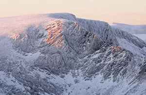
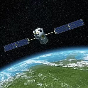
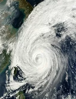
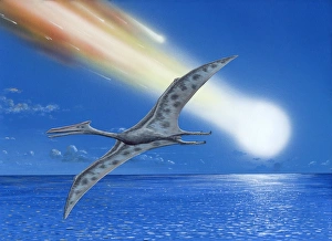
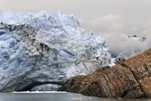
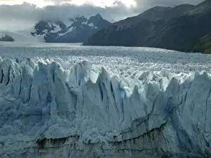
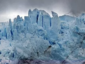
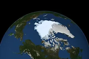
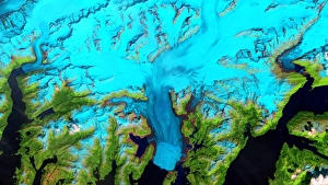
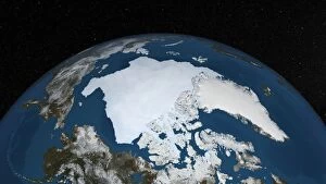
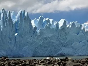
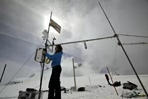
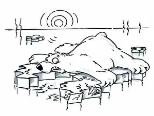
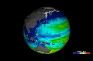
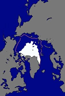
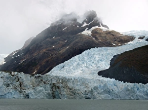
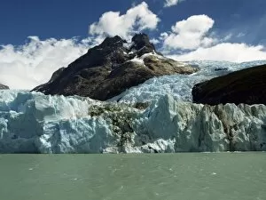
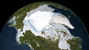
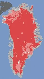
"Exploring the Climates of our Planet: From Antarctica to Typhoons" Water vapour maps of Antarctica, 2004: Unveiling the hidden secrets of Earth's southernmost continent through detailed water vapor mapping. Northern Corries at dawn: Witnessing the breathtaking beauty as the sun rises over the majestic Northern Corries, a glimpse into nature's morning symphony. Orbiting Carbon Observatory, artwork: A captivating artistic representation of a satellite dedicated to monitoring and understanding carbon dioxide levels in our atmosphere. Wilkins Ice Shelf, Antarctica: Marveling at the vast expanse of ice that is both awe-inspiring and indicative of our changing climate. Snowball Earth, artwork C018 / 8568: Imagining an ancient frozen world where glaciers covered every corner - a reminder of Earth's dynamic climatic history. Typhoon Tokage: The raw power and destructive force unleashed by this typhoon serves as a stark reminder of how weather patterns can shape our lives. Cretaceous-Tertiary extinction event: Reflecting on one of Earth's most significant climatic events that forever altered life on our planet millions of years ago. Sea surface salinity, Aquarius image C017 / 6816: Delving into oceanography with this stunning image capturing variations in sea surface salinity - essential for understanding global climate systems. Perito Moreno Glacier, Argentina F008 / 3645/3643/3654/3652 (multiple images): Journeying to Argentina's magnificent glacier where time seems frozen amidst its ever-changing icy landscape - an emblematic symbol for climate change awareness. Intriguing glimpses into various aspects related to climatology offer us opportunities to deepen our understanding and appreciation for Earth’s intricate systems – from remote Antarctic landscapes to powerful typhoons or even ancient cataclysmic events shaping our planet's history.