Home > Science > Space Exploration > Satellite Imagery
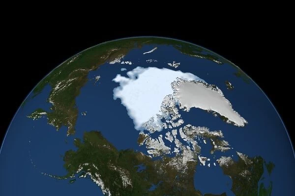
Arctic ice minimum extent, 2012
![]()

Wall Art and Photo Gifts from Science Photo Library
Arctic ice minimum extent, 2012
Arctic ice minimum extent. Satellite image showing the Arctic polar ice cap at its annual minimum extent on 16th September 2012. The Arctic sea ice (white with blue tint) reaches a minimum in September, at the end of the Arctic summer. This minimal ice area is called the perennial ice cover. The perennial ice has been steadily decreasing since satellites began observing it in 1979, at a rate of about 10 percent per decade. This was the lowest recorded minimum, at just over 3.4 million square kilometres. This decrease is attributed to global warming. Data from the Special Sensor Microwave Imager (SSMI) instrument on the US Air Forces Defense Meteorological Satellite Program (DMSP)
Science Photo Library features Science and Medical images including photos and illustrations
Media ID 9273181
© NASA/SCIENCE PHOTO LIBRARY
Annual Arctic Arctic Circle Arctic Ocean Climate Change Climatological Climatology Declining Disappearing Dmsp Earth Observation Environmental From Space Global Warming Losing Melting Passage Province Recede Receding Region Retreat Retreating Satellite Satellite Image Sea Ice Shrinking Smallest Strait Decline Declined Imager Polar Ice Cap Receded Retreated Vanishing
EDITORS COMMENTS
This print from Science Photo Library showcases the Arctic ice minimum extent in 2012. Taken on September 16th, this satellite image depicts the annual minimum extent of the Arctic polar ice cap. The white expanse with a subtle blue tint represents the diminishing Arctic sea ice, reaching its lowest recorded minimum at just over 3.4 million square kilometers. Referred to as the perennial ice cover, this minimal ice area has been steadily decreasing since satellite observations began in 1979. Experts estimate that it is declining at a rate of approximately 10 percent per decade, an alarming trend attributed to global warming and climate change. The data used for this image was collected by the Special Sensor Microwave Imager (SSMI) instrument on the US Air Forces Defense Meteorological Satellite Program (DMSP). It offers valuable insights into Earth's climatological changes and highlights how human activities impact our environment. As we observe this vanishing landscape through space-based technology, it serves as a stark reminder of our planet's vulnerability and emphasizes the urgent need for action to mitigate further melting and loss of sea ice. This visual evidence underscores both the fragility of our natural world and humanity's responsibility to protect it for future generations.
MADE IN AUSTRALIA
Safe Shipping with 30 Day Money Back Guarantee
FREE PERSONALISATION*
We are proud to offer a range of customisation features including Personalised Captions, Color Filters and Picture Zoom Tools
SECURE PAYMENTS
We happily accept a wide range of payment options so you can pay for the things you need in the way that is most convenient for you
* Options may vary by product and licensing agreement. Zoomed Pictures can be adjusted in the Cart.

