
Ecclesfield Collection
Ecclesfield, a historic village in Yorkshire, has witnessed centuries of significant events and developments


All Professionally Made to Order for Quick Shipping
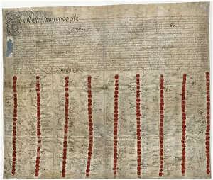
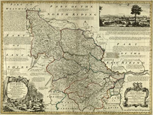
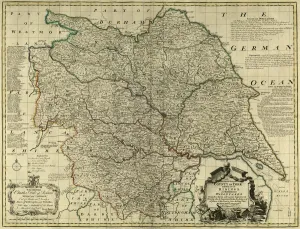
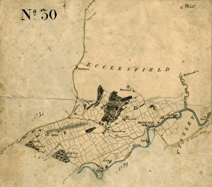
Ecclesfield, a historic village in Yorkshire, has witnessed centuries of significant events and developments. Dating back to the 18th century, the Ecclesfield Nailmakers Agreement of 1733 marked an important milestone in the local economy. This agreement solidified the nailmaking industry's regulations and standards, laying the foundation for its growth. The map of Hesley Farm in Ecclesfield from 1764 provides a glimpse into the agricultural landscape that once dominated this region. It showcases how farming played a vital role in sustaining the community during those times. Moving forward to 1793, we find a plan depicting Duke of Norfolk's Allotments on Grenno Moor. These allotments were crucial for providing land to local residents for cultivation or grazing purposes, ensuring their self-sufficiency. Stocks Hill is another notable location within Ecclesfield that flourished during the early 1900s. The image captures its charm and character as it stood proudly amidst surrounding buildings and greenery. In William Bingley's eye sketch from 1809, Oakes in Bradfield Chapelry reveals picturesque countryside scenery near Ecclesfield parish. This artwork offers us an artistic representation of nature's beauty intertwined with human settlements. Fast forward to Paul Bright's plan from 1842 showcasing freehold land allotted for sale in Bradfield township within Ecclesfield parish. This document sheds light on changing property ownership patterns over time and highlights economic activities such as real estate transactions. County maps dating back to around 1777 provide broader context by illustrating Yorkshire’s vastness while pinpointing specific regions like West Riding where Ecclesfield resides. These maps offer insights into transportation routes, neighboring towns, and geographical features that shaped life in this area. The Feoffees House or Feoffees Hall stands as a testament to social welfare efforts undertaken by Ecclesfield Parish during the early-1700s when it was erected as a workhouse.