Fraud Blocker Skip to main content

Enhanced Thematic Mapper Plus Collection

"Discover the World through Enhanced Thematic Mapper Plus

Background imageEnhanced Thematic Mapper Plus Collection: Dead Sea, 2011 satellite image C014 / 4705

Dead Sea, 2011 satellite image C014 / 4705
Dead Sea. False-colour satellite image of the Dead Sea. North is at top. Deep waters are blue or dark blue, while brighter blues indicate shallow waters or salt ponds (in the south)

Background imageEnhanced Thematic Mapper Plus Collection: London, true-colour satellite image C016 / 3888

London, true-colour satellite image C016 / 3888
London and its surrounds, true-colour satellite image. North is at top. The Thames Estuary is at right. London is the capital city of the UK

Background imageEnhanced Thematic Mapper Plus Collection: London, infrared satellite image C016 / 3890

London, infrared satellite image C016 / 3890
London and its surrounds, infrared satellite image. North is at top. The Thames Estuary is at right. This view is used for geological, agricultural

Background imageEnhanced Thematic Mapper Plus Collection: London, infrared satellite image C016 / 3889

London, infrared satellite image C016 / 3889
London and its surrounds, infrared satellite image. North is at top. The Thames Estuary is at right. This view is used for studies of vegetation

Background imageEnhanced Thematic Mapper Plus Collection: Cyprus, satellite image C016 / 3887

Cyprus, satellite image C016 / 3887
Cyprus, satellite image. North is at top. Vegetation is green, bare ground is brown and tan, built up areas are grey, and water is dark blue

Background imageEnhanced Thematic Mapper Plus Collection: Lambert Glacier, Antarctica

Lambert Glacier, Antarctica

Background imageEnhanced Thematic Mapper Plus Collection: Lena River Delta, Russia

Lena River Delta, Russia

Background imageEnhanced Thematic Mapper Plus Collection: Ganges Delta

Ganges Delta

Background imageEnhanced Thematic Mapper Plus Collection: Sahara Desert, Chad

Sahara Desert, Chad, satellite image. This area of the Sahara Desert is a rocky landscape with cliffs (one running down from upper right) amid the arid landscape (orange)

Background imageEnhanced Thematic Mapper Plus Collection: Lake Carnegie, Australia

Lake Carnegie, Australia, satellite image. Water (blue) is seen flooding this normally arid area in Western Australia. This is the western end of Lake Carnegie

Background imageEnhanced Thematic Mapper Plus Collection: West Fjords, Iceland

West Fjords, Iceland, satellite image. This jagged coastline is found in the West Fjords (Vestfirdir) peninsula in the north-west of Iceland. White snow and ice covers the mountain peaks

Background imageEnhanced Thematic Mapper Plus Collection: New Orleans

New Orleans. True-colour satellite image of the city of New Orleans (lower centre), Louisiana, USA. North is at top. Vegetation is green, water is blue and urban areas are white/grey


All Professionally Made to Order for Quick Shipping

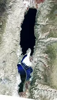
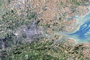
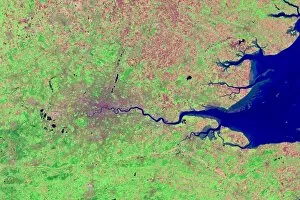
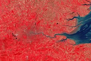
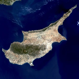
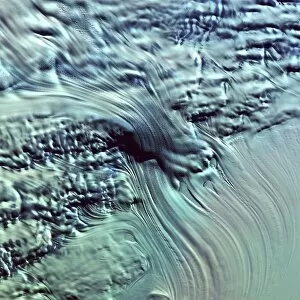
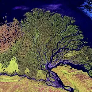
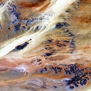
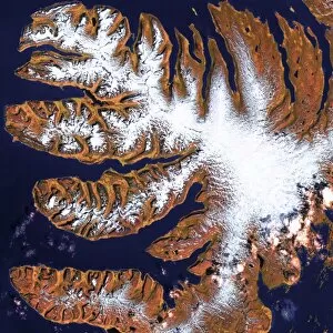
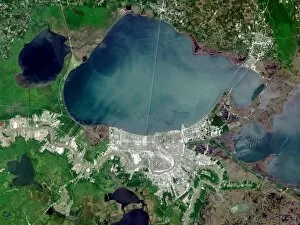
"Discover the World through Enhanced Thematic Mapper Plus: A Journey of Spectacular Satellite Images" Embark on a visual voyage across breathtaking landscapes and iconic landmarks with the remarkable capabilities (ETM+). This advanced satellite imaging technology offers an unprecedented glimpse into our planet's diverse terrains, capturing stunning details that unveil hidden wonders. In 2011, ETM+ captured an awe-inspiring satellite image C014/4705 of the mesmerizing Dead Sea. The vibrant colors and intricate patterns showcase nature's artistry in this unique saltwater lake nestled between Jordan and Israel. Traveling to London, true-color satellite image C016/3888 reveals the bustling metropolis in all its glory. From the majestic River Thames snaking through the city to its iconic landmarks like Big Ben and Tower Bridge, witness London's timeless beauty from a bird's-eye perspective. Delving deeper into London's secrets, infrared satellite images C016/3890 and C016/3889 expose unseen layers beneath its surface. These thermal images uncover heat signatures, highlighting urban development patterns and providing invaluable insights for city planning. Venturing further afield, Cyprus comes alive in satellite image C016/3887. Its captivating coastlines adorned with golden beaches beckon travelers seeking Mediterranean bliss while ancient ruins whisper tales of civilizations past. Journeying southward to Antarctica, Lambert Glacier stands as a testament to Earth's frozen majesty. ETM+ captures this colossal ice stream stretching across vast distances—a sight that leaves us humbled by nature's grandeur. The Lena River Delta in Russia showcases another facet of our planet’s rich tapestry. Satellite imagery unveils intricate networks of waterways weaving their way through lush greenery—an ecosystem teeming with life against a backdrop of serene beauty. Exploring Asia brings us to the Ganges Delta—where one river gives birth to countless channels nourishing fertile lands dotted with vibrant communities.