Home > Science > Space Exploration > Satellite Imagery
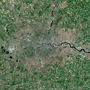
London, infrared satellite image C016 / 3890

![]()
Wall Art and Photo Gifts from Science Photo Library
London, infrared satellite image C016 / 3890
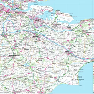
London and its surrounds, infrared satellite image. North is at top. The Thames Estuary is at right. This view is used for geological, agricultural, and wetlands research because it can help discriminate between various rock and mineral types. Bright green spots indicate vegetation and the waters appear dark blue or black. Urban areas appear as gray or pink, while cleared fields appear tan or purple. Image data obtained on 13 September 2002 by the Enhanced Thematic Mapper Plus (bands 7, 4, 2) on NASAs Landsat 7 satellite. For a true-colour and an alternative infrared version of this view, see images C016/3888 and C016/3889
Science Photo Library features Science and Medical images including photos and illustrations
Media ID 9204335
© NASA/ROBERT SIMMON/USGS/SCIENCE PHOTO LIBRARY
2002 Capital Cities City Coast Countryside Earth Observation Enhanced Thematic Mapper Plus Essex Fields From Space Greater London Human Geography Infrared Kent Land Land Cover Land Use Landsat 7 Largest London Region Rivers Rural Satellite Satellite Image Sequence Series Suburban Surrey Thames Thames Estuary Town Towns Urban Built Up Middlesex South East England Surroundings Surrounds
FEATURES IN THESE COLLECTIONS
> Science
> Space Exploration
> Satellite Imagery
EDITORS COMMENTS
This print showcases a stunning infrared satellite image of London and its surrounds. With the North positioned at the top, the Thames Estuary gracefully flows on the right side of the frame. This particular view holds immense value for geological, agricultural, and wetlands research as it aids in distinguishing between different rock and mineral types. The vibrant green spots scattered throughout indicate lush vegetation, while the waters of the Thames appear dark blue or black. Urban areas are depicted in shades of gray or pink, offering a glimpse into London's bustling cityscape. Cleared fields take on hues of tan or purple, adding to the diverse color palette captured by NASA's Enhanced Thematic Mapper Plus. Obtained on September 13th, 2002 by NASAs Landsat 7 satellite using bands 7,4, and 2; this image provides valuable insights into land use patterns within Greater London. From suburban to rural areas encompassing Middlesex, Surrey, Kent, Essex and more; this photograph encapsulates England's capital region with remarkable clarity. A testament to human geography in the early years of the twenty-first century; this awe-inspiring Earth observation from space allows us to appreciate both urban development and natural landscapes harmoniously coexisting. The intricate details revealed through infrared technology enable scientists to delve deeper into understanding our planet's ever-evolving dynamics - an invaluable tool for researchers worldwide.
MADE IN AUSTRALIA
Safe Shipping with 30 Day Money Back Guarantee
FREE PERSONALISATION*
We are proud to offer a range of customisation features including Personalised Captions, Color Filters and Picture Zoom Tools
SECURE PAYMENTS
We happily accept a wide range of payment options so you can pay for the things you need in the way that is most convenient for you
* Options may vary by product and licensing agreement. Zoomed Pictures can be adjusted in the Cart.