Fraud Blocker Skip to main content

Gerardus Collection

Gerardus, a name that resonates with the rich history of cartography and exploration

Background imageGerardus Collection: Atlas of Gerardus Mercator, 1595, map of the Arctic to the North Pole and surrounding

Atlas of Gerardus Mercator, 1595, map of the Arctic to the North Pole and surrounding lands within and outside the Arctic Circle

Background imageGerardus Collection: Septentrionalium Terrarum descriptio, 1595, by Gerardus Merc

Septentrionalium Terrarum descriptio, 1595, by Gerardus Merc
Gerardus Mercator (1512-1594). Flemish cartographer. Septentrionalium Terrarum descriptio. Map of the Arctic with the North Pole and surrounding lands within and outside the Arctic Circle, 1595

Background imageGerardus Collection: 17th century map of Europe

17th century map of Europe

Background imageGerardus Collection: 17th century map of the New World

17th century map of the New World
Western Hemisphere, 17th century Dutch map. This shows the New World that was being discovered by Europeans exploring the Western Hemisphere of the Earth

Background imageGerardus Collection: 16th century map of the British Isles

16th century map of the British Isles
British Isles, 16th century Dutch map. This shows England, Scotland, Wales and Ireland, though Ireland is not yet accurately mapped. Published in 1595, from work by Gerard Mercator

Background imageGerardus Collection: 17th century map of the New World

17th century map of the New World

Background imageGerardus Collection: Atlas of Gerardus Mercator, 1595. World Map

Atlas of Gerardus Mercator, 1595. World Map

Background imageGerardus Collection: 17th century map of South America

17th century map of South America
South America, 17th century Dutch map. This shows the new continent that was being discovered by European explorers. The shape is distorted because it had not yet been accurately mapped

Background imageGerardus Collection: JAPAN: MAP, 1606. Map of Japan engraved by Jodocus Hondius for a 1606 edition of Gerardus

JAPAN: MAP, 1606. Map of Japan engraved by Jodocus Hondius for a 1606 edition of Gerardus Mercators Atlas. Korea is shown as an island

Background imageGerardus Collection: Mercator, (1512-1594), 1830. Creator: Unknown

Mercator, (1512-1594), 1830. Creator: Unknown
Mercator, (1512-1594), 1830. Gerardus Mercator (1512-1594) Belgian geographer, cosmographer and cartographer known for his 1569 world map of sailing courses with rhumb lines

Background imageGerardus Collection: South America (America Meridionalis): from the Atlas of Gerardus Mercator, 1633, (1936)

South America (America Meridionalis): from the Atlas of Gerardus Mercator, 1633, (1936). Artist: Gerardus Mercator
South America (America Meridionalis): from the Atlas of Gerardus Mercator, 1633, (1936). Published at Antwerp by Hondius From The Connoisseur, Vol. 98, edited by H. Granville Fell

Background imageGerardus Collection: Gerrit Janszoon Vos, aka Gerardus Vossius

Gerrit Janszoon Vos, aka Gerardus Vossius
3252936 Gerrit Janszoon Vos, aka Gerardus Vossius by English School, (19th century); (add.info.: Gerrit Janszoon Vos, 1577-1649, aka Gerardus Vossius. Dutch classical scholar and theologian)

Background imageGerardus Collection: Map of the Americas1633 Date: 1633

Map of the Americas1633 Date: 1633

Background imageGerardus Collection: Map of Africa 1633 Date: 1633

Map of Africa 1633 Date: 1633

Background imageGerardus Collection: Map of Asia 1633 Date: 1633

Map of Asia 1633 Date: 1633

Background imageGerardus Collection: Christ Healing the Blindman, ca. 1725-30. Creator: Gerardus Duyckinck

Christ Healing the Blindman, ca. 1725-30. Creator: Gerardus Duyckinck
Christ Healing the Blindman, ca. 1725-30

Background imageGerardus Collection: Northern End of Palisades, Hudson River, c1897. Creator: Unknown

Northern End of Palisades, Hudson River, c1897. Creator: Unknown
Northern End of Palisades, Hudson River, c1897. The Palisades, are a line of steep basalt cliffs along the west side of the lower Hudson River, they appear on the first European map of the New World

Background imageGerardus Collection: Atlas of Gerardus Mercator, 1595, map of the Americas and part of Antarctica

Atlas of Gerardus Mercator, 1595, map of the Americas and part of Antarctica

Background imageGerardus Collection: Map of the World on Mercators Projection, 1902

Map of the World on Mercators Projection, 1902
Map - The World on Mercators Projection, 1902. From The Living Races of Mankind, Vol. I. [Hutchinson & Co, London, 1902]

Background imageGerardus Collection: MERCATOR, Gerhard Kremer, called Gerardus (1512-1594)

MERCATOR, Gerhard Kremer, called Gerardus (1512-1594). Earth Globe by Mercator. Dimensions: 64 x 55 cm. Diameter: 41 cm. BELGIUM. Sint-Nikls. Mercatormuseum

Background imageGerardus Collection: Gerrit Janszoon Vos, 1577 - 1649, aka Gerardus Vossius. Dutch classical scholar and theologian

Gerrit Janszoon Vos, 1577 - 1649, aka Gerardus Vossius. Dutch classical scholar and theologian

Background imageGerardus Collection: Gerardus Mercator, 1512-1594. Flemish Cartographer. The Mercator Projection Is Named After Him

Gerardus Mercator, 1512-1594. Flemish Cartographer. The Mercator Projection Is Named After Him. From Crabbs Historical Dictionary Published 1825

Background imageGerardus Collection: Gerardus Mercator 1512 To 1594 Flemish Cartographer After A 19Th Century Illustration

Gerardus Mercator 1512 To 1594 Flemish Cartographer After A 19Th Century Illustration

Background imageGerardus Collection: Gerard Groot

Gerard Groot
GERARD GROOT (or GERARDUS MAGNUS) Flemish churchman, founder of a monastic establishment, depicted writing from a celestial revelation. Date: 1340 - 1384

Background imageGerardus Collection: MAP OF ARCTIC REGION, 1595. Gerardus Mercators map of the Arctic region

MAP OF ARCTIC REGION, 1595. Gerardus Mercators map of the Arctic region, published 1595 in Dusseldorf, Germany

Background imageGerardus Collection: Gerardus Mercator

Gerardus Mercator
GERARDUS MERCATOR Known also as Gerhard Kremer Flemish cartographer

Background imageGerardus Collection: Gerhard Johannes Vossius - Dutch scholar

Gerhard Johannes Vossius - Dutch scholar
Gerhard Johannes Vossius (1577-1649) - Dutch scholar. Date: circa 1640

Background imageGerardus Collection: Gerardus Mercator (1512-1594). Engraving

Gerardus Mercator (1512-1594). Engraving
Gerardus Mercator (1512-1594). Flemish cartographer. Engraving, 1595

Background imageGerardus Collection: Drawings Prints, Drawing, Cow Lying Landscape, Artist, Pieter, Gerardus, van, Os

Drawings Prints, Drawing, Cow Lying Landscape, Artist, Pieter, Gerardus, van, Os
Drawings and Prints, Drawing, A Cow Lying in a Landscape, Artist, Pieter Gerardus van Os, Dutch, The Hague 1776-1836 The Hague, Os, Pieter Gerardus van, Dutch, 1776, 1836, early 19th century, 1796

Background imageGerardus Collection: Portrait of Gerardus Joannes Vossius, print maker: Theodor Matham, Joachim von Sandrart

Portrait of Gerardus Joannes Vossius, print maker: Theodor Matham, Joachim von Sandrart, 1615 - 1676

Background imageGerardus Collection: Portrait of Gerardus Puppius Hondius, Louis Lucas, G. Lucas, c. 1650 - 1731

Portrait of Gerardus Puppius Hondius, Louis Lucas, G. Lucas, c. 1650 - 1731

Background imageGerardus Collection: Portrait of Gerardus Mercator, print maker: Hendrick Goltzius attributed to, Frans

Portrait of Gerardus Mercator, print maker: Hendrick Goltzius attributed to, Frans Hogenberg, Johannes Vivianus, 1576

Background imageGerardus Collection: Portrait of Gerardus Oorthuys, Robbert Muys, 1782

Portrait of Gerardus Oorthuys, Robbert Muys, 1782

Background imageGerardus Collection: Portrait of Pieter Gerardus van Os. Jacob Ernst Marcus, Hendrik Willem Caspari, 1816

Portrait of Pieter Gerardus van Os. Jacob Ernst Marcus, Hendrik Willem Caspari, 1816

Background imageGerardus Collection: Medal in honor of Gerardus Oorthuys, captain of the frigate Den Briel, Noach van der Meer

Medal in honor of Gerardus Oorthuys, captain of the frigate Den Briel, Noach van der Meer (II), 1781 - 1782

Background imageGerardus Collection: Portrait of Gerardus Oorthuys, Robbert Muys, Jan Krap Az, 1752 - 1825

Portrait of Gerardus Oorthuys, Robbert Muys, Jan Krap Az, 1752 - 1825

Background imageGerardus Collection: The geographers and cartographers Gerardus Mercator

The geographers and cartographers Gerardus Mercator (left) and Jodocus Hondius. Etching. BELGIUM. Sint-Nikls. Mercatormuseum

Background imageGerardus Collection: GERHARDUS MERCATOR (1512-1594). Flemish geographer. Wood engraving, 19th century

GERHARDUS MERCATOR (1512-1594). Flemish geographer. Wood engraving, 19th century

Background imageGerardus Collection: GERARDUS MERCATOR (1512-1594). Flemish geographer. Contemporary copper engraving by Franz Hogenberg

GERARDUS MERCATOR (1512-1594). Flemish geographer. Contemporary copper engraving by Franz Hogenberg

Background imageGerardus Collection: 17th century map of Japan

17th century map of Japan
Japan, 17th century Dutch map. These lands had not yet been accurately mapped by Europeans, and the islands of Japan (centre to centre right) are much distorted


All Professionally Made to Order for Quick Shipping

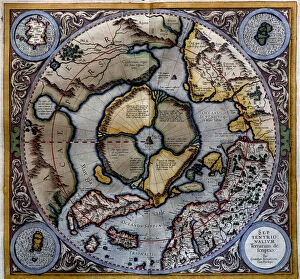
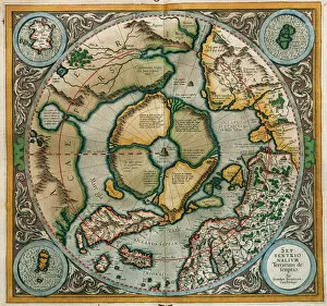
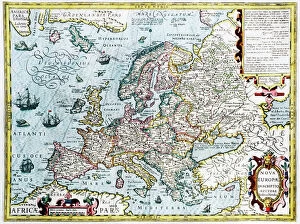
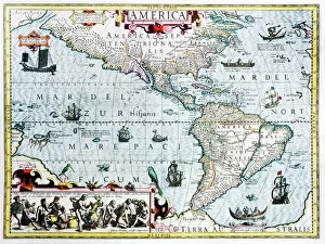
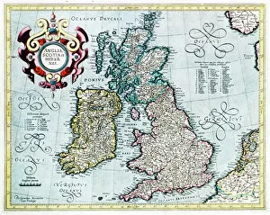
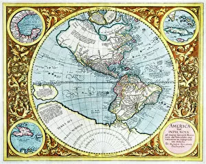
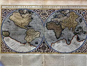
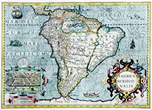
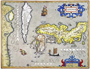
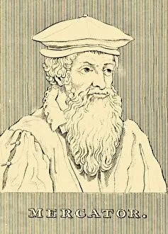
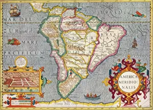
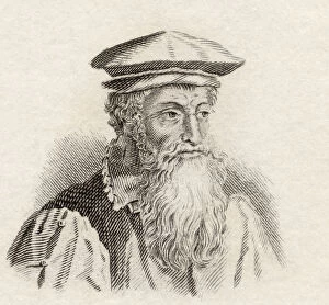
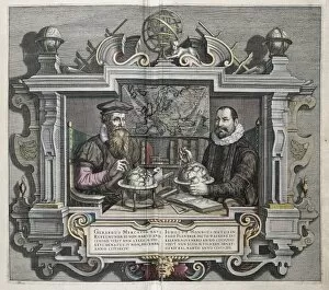
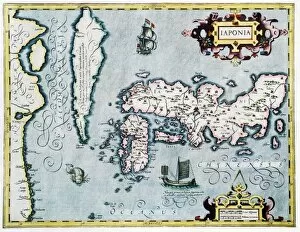
Gerardus, a name that resonates with the rich history of cartography and exploration. In the 17th century, maps were not just mere navigational tools but works of art that captured the imagination of adventurers and scholars alike. One such masterpiece was the "Septentrionalium Terrarum descriptio" by Gerardus Mercator in 1595. This map depicted Europe during a time when boundaries were shifting and empires rising. It showcased Mercator's exceptional skill in portraying geographical details with precision. The New World also found its place on these ancient maps, as seen in the 17th-century depiction. These maps revealed uncharted territories waiting to be discovered by intrepid explorers like Christopher Columbus or Ferdinand Magellan. Moving closer to home, a 16th-century map of the British Isles unveiled an intricate tapestry of islands steeped in history and folklore. It served as a testament to Gerardus' dedication to capturing every nuance of landmasses he encountered. Not limited to terrestrial realms, Gerardus ventured into unexplored frontiers like the Arctic region. His Atlas from 1595 included a map showcasing this icy expanse all the way up to the North Pole—a true testament to his ambition and thirst for knowledge. South America also fell under Gerardus' gaze, as evidenced by another captivating map from his collection. The vibrant colors brought this continent alive, inviting viewers on an imaginary journey through lush rainforests and mighty rivers. But it wasn't only geography that bore witness to Gerardus' influence; even Japan had its moment on his canvas. An intricately engraved map created by Jodocus Hondius for one edition of Mercator's Atlas showcased Japan as an island—an intriguing glimpse into how perceptions can shape our understanding of distant lands. Beyond cartography lies another facet of "Gerardus"—the individuals who carried this name throughout history.