Fraud Blocker Skip to main content

Mediterranean Sea Collection (page 19)

The Mediterranean Sea, a timeless expanse of beauty and history, has witnessed the rise and fall of empires throughout the ages

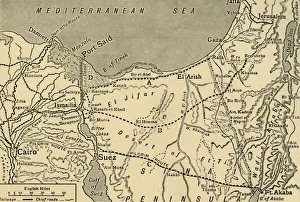
Background imageMediterranean Sea Collection: Map of Egypt and the Sinai Peninsula, 1917. Creator: Unknown

Map of Egypt and the Sinai Peninsula, 1917. Creator: Unknown
Map of Egypt and the Sinai Peninsula, 1917. Fighting began in January 1915, when a German-led Ottoman force invaded the Sinai Peninsula, then part of the British Protectorate of Egypt

Background imageMediterranean Sea Collection: Ottoman and Persian, after 1450 A. D. c1915. Creator: Emery Walker Ltd

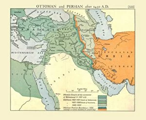
Ottoman and Persian, after 1450 A. D. c1915. Creator: Emery Walker Ltd
Ottoman and Persian, after 1450 A.D. c1915. Map of empires in the Middle East during the 15th-17th centuries: Ottoman Empire at the accession of Mohammed II, 1451 AD, Additions 1481-1683

Background imageMediterranean Sea Collection: Physical Map of the Ottoman Empire, c1915. Creator: Unknown

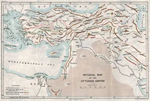
Physical Map of the Ottoman Empire, c1915. Creator: Unknown
Physical Map of the Ottoman Empire, c1915. Map showing the eastern Mediterranean, Cyprus, the Middle East, the rivers Tigris and Euphrates, what is now Turkey, and part of Egypt

Background imageMediterranean Sea Collection: Rome v. Persia (Sassanian), circa 300 A. D. c1915. Creator: Emery Walker Ltd

Rome v. Persia (Sassanian), circa 300 A. D. c1915. Creator: Emery Walker Ltd
Rome v. Persia (Sassanian), circa 300 A.D. c1915. Map of the eastern Mediterranean and Near East, showing the ancient empires of Rome, Persia, and Armenia

Background imageMediterranean Sea Collection: The Abbasid Caliphate v. Byzantine Empire, circa 786 A. D. c1915. Creator: Emery Walker Ltd

The Abbasid Caliphate v. Byzantine Empire, circa 786 A. D. c1915. Creator: Emery Walker Ltd
The Abbasid Caliphate v. Byzantine Empire, circa 786 A.D. c1915. Map of civilisations in the Middle East during the 8th century, and also showing the eastern Mediterranean, Red Sea, Caspian Sea

Background imageMediterranean Sea Collection: The Omayyad Caliphate v. Byzantine Empire, circa 748 A. D. c1915. Creator: Emery Walker Ltd

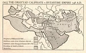
The Omayyad Caliphate v. Byzantine Empire, circa 748 A. D. c1915. Creator: Emery Walker Ltd
The Omayyad Caliphate v. Byzantine Empire, circa 748 A.D. c1915. Map of the Mediterranean and Near East, showing the Kingdom of Mohammed, Additions under the Caliphs

Background imageMediterranean Sea Collection: Map showing the movements of HMS Ark Royal, 1939-1941, (1942). Creator: Unknown

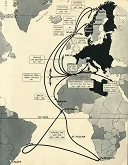
Map showing the movements of HMS Ark Royal, 1939-1941, (1942). Creator: Unknown
Map showing the movements of HMS Ark Royal, 1939-1941, (1942). Map of the Atlantic Ocean, western Europe and Africa, indicating journeys

Background imageMediterranean Sea Collection: Lemon-yellow tree frog (Hyla savignyi) peering around coastal plant. Cyprus. April

Lemon-yellow tree frog (Hyla savignyi) peering around coastal plant. Cyprus. April

Background imageMediterranean Sea Collection: Map of the Turkish attack on the Suez Canal, Egypt, First World War, 1915, (c1920)

Map of the Turkish attack on the Suez Canal, Egypt, First World War, 1915, (c1920). Map showing approximately the direction of the Turkish Attack on the Suez Canal, January 25 - February 3, 1915

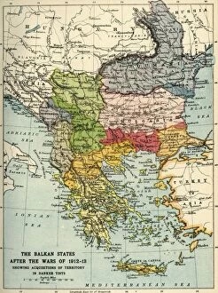
Background imageMediterranean Sea Collection: The Balkan States After the Wars of 1912-13, (c1920). Creator: John Bartholomew & Son

The Balkan States After the Wars of 1912-13, (c1920). Creator: John Bartholomew & Son
The Balkan States After the Wars of 1912-13, (c1920). Showing Acquisitions of Territory in Darker Tints. Map of the Balkans: Bosnia, Montenegro, Servia (Serbia), Albania, Roumania (Romania)

Background imageMediterranean Sea Collection: The Rebellion of Arabi Pasha in Egypt, 1882: The Bombardment of Alexandria... (1901)

The Rebellion of Arabi Pasha in Egypt, 1882: The Bombardment of Alexandria... (1901)
The Rebellion of Arabi Pasha in Egypt, 1882: The Bombardment of Alexandria by the British Fleet, (1901). Episode of the Anglo-Egyptian War

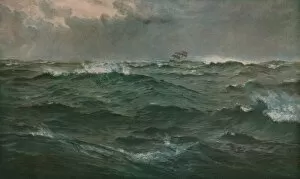
Background imageMediterranean Sea Collection: Rough Weather in the Mediterranean, 1874, (c1930). Creator: Henry Moore

Rough Weather in the Mediterranean, 1874, (c1930). Creator: Henry Moore
Rough Weather in the Mediterranean, 1874, (c1930). A sailing ship struggling in stormy seas. Painting in the Blackburn Museum and Art Gallery, Lancashire

Background imageMediterranean Sea Collection: Striped Dolphin (Stenella coeruleoalba) in the strait of Gibraltar, Spain

Striped Dolphin (Stenella coeruleoalba) in the strait of Gibraltar, Spain

Background imageMediterranean Sea Collection: Spotted catshark (Scyliorhinus canicula) just hatched from egg case that is on Seafan

Spotted catshark (Scyliorhinus canicula) just hatched from egg case that is on Seafan (Paramuricea clavata), Ullastres seamount, Costa Brava, Llafranch, Catalunya, Spain

Background imageMediterranean Sea Collection: North Africa, from a nautical atlas, 1520 (ink on vellum) (detail from 330916)

North Africa, from a nautical atlas, 1520 (ink on vellum) (detail from 330916)
XOT330918 North Africa, from a nautical atlas, 1520 (ink on vellum) (detail from 330916) by Giovanni Xenodocus da Corfu (fl. 16th Century); Museo Correr, Venice, Italy; Greek, out of copyright

Background imageMediterranean Sea Collection: Pearlfish (Carapus acus) outside of host Sea cucumber (Stichopus regalis) at night

Pearlfish (Carapus acus) outside of host Sea cucumber (Stichopus regalis) at night. These species have a commensal relationship, with the fish living in the gut of the sea cucumber. Catalonia, Spain

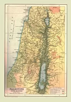
Background imageMediterranean Sea Collection: Map of Palestine, Ancient and Modern, 1902. Creator: Unknown

Map of Palestine, Ancient and Modern, 1902. Creator: Unknown
Map of Palestine, Ancient and Modern, 1902. Showing the Mediterrean coast, Sea of Galilee and the Dead Sea. From The Century Atlas of the World. [John Walker & Co, Ltd. London, 1902]

Background imageMediterranean Sea Collection: Old map showing Rome arround 1st century BC

Old map showing Rome arround 1st century BC
Old map showing Rome circa 1st century bc Original edition from my own archives Source : Illustriertes Konversations Lexikon 1878

Background imageMediterranean Sea Collection: Afternoon sunrays dancing over rocks, in shallow water. Capo Comino, Sardinia, Italy

Afternoon sunrays dancing over rocks, in shallow water. Capo Comino, Sardinia, Italy. Mediterranean Sea

Background imageMediterranean Sea Collection: RF- Small jellyfish (Pelagia noctiluca) swimming beneath surface

RF- Small jellyfish (Pelagia noctiluca) swimming beneath surface. Marine Protected Area of Portofino (Area Marina Protetta, Portofino), Liguria, Italy. Mediterranean Sea

Background imageMediterranean Sea Collection: europe map 1829

europe map 1829
an old map form 1829, showing the whole europe

Background imageMediterranean Sea Collection: St Pauls Bay, Malta

St Pauls Bay, Malta. St Pauls Bay gets its name from the shipweck of St Paul nearby on the Maltese coast

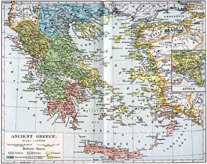
Background imageMediterranean Sea Collection: Map of Ancient Greece, 1902

Map of Ancient Greece, 1902. Illustration from The Worlds History, The Mediterranean Nations, by Dr H F Helmolt, Volume IV, published by William Heinemann, (London, 1902)

Background imageMediterranean Sea Collection: Rocky coast with waterfalls on Euboa, 1893. Creator: Thorvald Niss

Rocky coast with waterfalls on Euboa, 1893. Creator: Thorvald Niss
Rocky coast with waterfalls on Euboa, 1893


All Professionally Made to Order for Quick Shipping

The Mediterranean Sea, a timeless expanse of beauty and history, has witnessed the rise and fall of empires throughout the ages. As we explore its rich tapestry through various maps and lithographs, we are transported to different eras that have shaped our world. Let's begin our journey with a Map of Cyprus from 1880, revealing the island's strategic location in the heart of this ancient sea. It serves as a gateway to Apostle Paul's Missionary Journeys depicted in an 1886 lithograph. These journeys spread Christianity across lands touched by the Mediterranean's gentle waves. Moving forward in time, we encounter a Map of the Byzantine Empire in the 9th Century. This empire once dominated these shores with its grandeur and influence. Further west lies Portugal on another map, reminding us of their maritime prowess during Europe's Age of Exploration. As we delve deeper into history, Medieval Europe at the start of the Crusades comes alive before us. The clash between East and West reverberates across these waters as kingdoms vie for control amidst religious fervor. Sicily unveils itself through a map from 1895 – an island steeped in diverse cultures due to its strategic position within this sea. Ancient Palestine emerges next with maps showcasing kingdoms like Judah and Israel; lands where stories from biblical times unfolded against this breathtaking backdrop. Greece takes center stage as we witness it at the beginning of one of history's most famous conflicts -the Peloponnesian War (431-404 BC). City-states battle for supremacy while leaving an indelible mark on Western civilization. A View of Old Town City Dubrovnik captures our attention next; its medieval walls standing strong against time’s relentless march. This Croatian gem reminds us how coastal cities flourished along these shores since antiquity.