
Satellite Imagery Collection
Satellite Imagery: A Glimpse into Earth's Wonders and Challenges From the vast deserts of the Middle East to the mesmerizing beauty of Australasia

All Professionally Made to Order for Quick Shipping
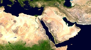
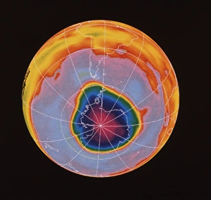
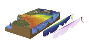
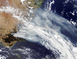
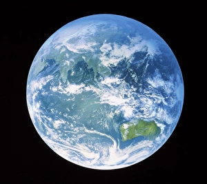
Satellite Imagery: A Glimpse into Earth's Wonders and Challenges From the vast deserts of the Middle East to the mesmerizing beauty of Australasia, satellite imagery unveils a world full of wonders and challenges. High above our planet, satellites capture breathtaking images that provide invaluable insights into various phenomena. They allow us to witness nature's delicate balance, such as the hauntingly beautiful ozone hole over Antarctica – a stark reminder of our responsibility to protect our fragile atmosphere. In the realm of oceanography, satellite data like C016 / 3739 reveals intricate details about the north-western Atlantic. These observations help scientists understand ocean currents, temperature variations, and marine life patterns—essential for preserving this vital ecosystem. Moreover, bathymetry models like C016 / 3738 shed light on underwater landscapes in the same region. With these tools at hand, researchers can unravel hidden mysteries beneath the waves while safeguarding precious marine resources. The Australian bushfires brought devastation beyond imagination; however, satellite imagery captured another dimension—the smoke billowing across vast distances. This visual evidence serves as a call to action against climate change and emphasizes how interconnected our world truly is. By centering Earth on Australasia through satellite imagery lenses, we gain an alternative perspective—a fresh outlook on global dynamics. It reminds us that every corner of this blue planet holds significance and deserves attention in shaping policies for sustainable development. Returning once again to the Middle East—an area rich with history—satellite imagery allows us to explore ancient ruins from above. From majestic pyramids in Egypt to architectural marvels in Jordan or Iraq—these images bridge past civilizations with modern times while igniting curiosity about humanity's journey throughout millennia. Satellite imagery has become an indispensable tool for understanding our planet better than ever before. It enables us not only to appreciate its awe-inspiring beauty but also empowers us with knowledge necessary for informed decision-making towards a sustainable future.