Fraud Blocker Skip to main content

Surveying Collection (page 10)

"Surveying: Unveiling the Past, Charting the Future" Step into a journey of discovery as we delve into the fascinating world of surveying

Background imageSurveying Collection: Dredging New York, 19th century

Dredging New York, 19th century
Dredging New York harbour. The steamboat at left is using an apparatus suspended below it to survey the harbour floor and take soundings to determine which areas need dredging

Background imageSurveying Collection: Naval observation balloon, 19th century

Naval observation balloon, 19th century artwork. The balloon (upper right) is tethered to the ship below, and is being used to survey the movement of enemy ships and forces

Background imageSurveying Collection: Iron distribution map, Barringer Crater

Iron distribution map, Barringer Crater
Iron distribution map for Barringer Crater, Arizona, USA, also known as Meteor Crater. A six-mile (9.65-kilometre) radius circle, centred on the crater

Background imageSurveying Collection: Woodcut of a cosmolabe

Woodcut of a cosmolabe
Cosmolabe. 16th century woodcut illustration showing a cosmolabe. A cosmolabe is an instrument similar to an astrolabe used to measure angles between celestial objects

Background imageSurveying Collection: Pantometer, 16th Century

Pantometer, 16th Century
Pantometer. 16th century engraving showing the design of a pantometer. This is used to determine the bearing and elevation to a given point

Background imageSurveying Collection: Surveyor at work with a theodolite

Surveyor at work with a theodolite
A surveyor at work with a theodolite level

Background imageSurveying Collection: Policemen on a stake-out

Policemen on a stake-out
Non-uniformed police officers and detectives on a stake-out sit in a large unmarked car, watching and waiting

Background imageSurveying Collection: Cavaignac in Paris

Cavaignac in Paris
Cavaignac, in charge of maintaining order in Paris, tours the city with Lamartine, Pierre Napoleon (son of Lucien) and their entourage, surveying the damage

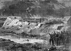
Background imageSurveying Collection: The Civil war in America; aftermath of the battle at Fort Wa

The Civil war in America; aftermath of the battle at Fort Wa
Confederate soldiers surveying the damage after the battle at Fort Wagner, South Carolina. The Black regiment of the 54th Massachusetts lost 40% of their men here on the 18th July 1863. Date: 1863

Background imageSurveying Collection: Zulu war sketches by our special artist. Interior of the old

Zulu war sketches by our special artist. Interior of the old
British soldiers surveying the damage to the old fort at Rorkes Drift, where 137 British soldiers held out against 3, 000 zulus at the beginning of the Zulu wars

Background imageSurveying Collection: Gold at Monte Rosa 2

Gold at Monte Rosa 2
Surveying the valleys

Background imageSurveying Collection: Mathematicians

Mathematicians
Two scholars use a mathematical device, perhaps to help them in some surveying or astronomical calculations

Background imageSurveying Collection: Tierra Del Fuego

Tierra Del Fuego
A surveying party of British sailors from HMS Nassau are attacked by natives of Tierra del Fuego, which is divided between Argentina and Chile

Background imageSurveying Collection: Surveying with a Compass

Surveying with a Compass
Surveying with a mounted compass

Background imageSurveying Collection: A theodolite, used for surveying

A theodolite, used for surveying

Background imageSurveying Collection: Tony Cooper a volunteer bird surveyor for the British Trust for Ornithology

Tony Cooper a volunteer bird surveyor for the British Trust for Ornithology
Ashley Cooper / SpecialistStock

Background imageSurveying Collection: A surveyor working on a construction project in Dubai

A surveyor working on a construction project in Dubai
Ashley Cooper / SpecialistStock

Background imageSurveying Collection: Vultures, Masai Mara National Park

Vultures, Masai Mara National Park, Kenya, East Africa, Africa

Background imageSurveying Collection: Cheetah (Acinonyx jubatus) lying down while surveying an open plain

Cheetah (Acinonyx jubatus) lying down while surveying an open plain, Masai Mara National Reserve, Kenya, East Africa, Africa

Background imageSurveying Collection: Social / Ludgate 1931

Social / Ludgate 1931
A policeman crouches on a stand whilst surveying the traffic at Ludgate Circus, London

Background imageSurveying Collection: Theodolite for Survey

Theodolite for Survey
A dapper surveyor and his fine theodolite

Background imageSurveying Collection: Rail Surveying Canada

Rail Surveying Canada
Surveying for a new railway line through the Canadian Rockies

Background imageSurveying Collection: Surveying Aussie Rail

Surveying Aussie Rail
Surveyors in a camel-drawn carriage reconnoitre the route for the trans-continental railway which will cross central Australia

Background imageSurveying Collection: Surveying Panama Canal

Surveying Panama Canal
Surveying under difficulties : the terrain is rough and densely covered, jungle in some places, swamp in others


All Professionally Made to Order for Quick Shipping

"Surveying: Unveiling the Past, Charting the Future" Step into a journey of discovery as we delve into the fascinating world of surveying. From historic battles to breathtaking landscapes, this captivating practice has shaped our understanding of the world around us. In 1982, during the Falklands War, surveyors played a crucial role in mapping out strategic locations and guiding troops through treacherous terrains. Similarly, in Lord Chelmsford's retreat from Isandhlwana during The Zulu War, surveying knowledge proved vital for navigating challenging landscapes. Travel back to 1872 with Gustave Doré's masterpiece "The New Zealander, " where surveyors meticulously measured and mapped uncharted territories. Their dedication paved the way for exploration and development. Closer to home, Larkswood Lido stands as a testament to meticulous planning by skilled surveyors who ensured every inch was perfectly aligned. Meanwhile, atop Wild Boar Fell in the north Pennines UK stands a trig point—a symbol of precision measurement that aids navigation across vast expanses. Venturing underground reveals surface buildings from Basset Mines in Illogan, Cornwall circa 1906. Surveyors painstakingly documented these structures that once thrived with activity—now preserved as historical landmarks. Alfred Stephenson on Anchorage Island showcases how technology evolved over time. Armed with his trusty theodolite—an instrument used for measuring angles—he captured precise data that contributed to scientific advancements. From ancient times to modern-day practices like PSCI2A-00073, young Washington's career as a surveyor laid foundations for his future leadership role. His experiences honed skills necessary for shaping nations and making history. Beyond measurements lie moments of collaboration; miniature depictions show surveyors sitting in circles during meetings—exchanging ideas and expertise—a tradition carried forward today within this vibrant community. Maps have always been invaluable tools; one such masterpiece is the 1891 color lithograph depicting Africa's treaty boundaries.